


The fact that Michigan went for democrats across the board and yet still have no traction in the state legislature just goes to show how powerful gerrymandering is.
Results 1 to 25 of 70
Hybrid View
-
November-07-18, 10:46 AM #1
 DetroitYES Member
- Join Date
- Apr 2009
- Posts
- 887

-
November-07-18, 02:41 PM #2
DetroitYES Member
- Join Date
- Mar 2009
- Posts
- 1,355
The fact that Democrats have spent the last few decades self-segregating themselves is responsible for much of their disproportionate lack of representation in Lansing. Outside of urban areas and some inner suburbs this state is almost entirely red, and it's nearly impossible to draw up a normal looking congressional map to fairly account for this. That said, I guess we'll soon find out what a "non-gerrymandered"[[As if such a thing exists) map actually looks like. Originally Posted by drjeff

Last edited by Johnnny5; November-07-18 at 02:44 PM.
-
November-07-18, 03:08 PM #3
DetroitYES Member
- Join Date
- Sep 2011
- Posts
- 772
Land doesn't vote. People do. One person, one vote. It shouldn't matter where they live. The state looks "almost entirely red" on a map specifically because of Republican gerrymandering. But even then, you'll still see lots of red on the map because there are massive swathes of this state where very few people live. An electoral map can look deceiving, they just show land, not population or population density. Originally Posted by Johnnny5
It's easy enough to spot a gerrymandered vs non-gerrymandered map. A non-gerrymandered, fairly drawn map will see the proportion of Democrats and Republicans in the state legislature closely approximate the percentage of votes that those two parties received statewide. There you go. It's literally that simple.
If 55% of Michiganders go to the polls and vote for Democrats for the legislature, and only 45% of elected legislators are Democrat, then your map is intentionally drawn in a way to dilute the Democratic vote in favor of the Republican vote.Last edited by aj3647; November-07-18 at 03:53 PM.
-
November-07-18, 06:18 PM #4
DetroitYES Member
- Join Date
- Jul 2013
- Posts
- 593
Well, actually, the task is somewhat more complicated. Under Michigan law [[pre-Prop 2) "communities of interest" were an important criteria. They continue as such under Prop 2. Originally Posted by aj3647
The text is:
"Proposal 2 required commissioners to prioritize the following criteria, in the order as listed, for proposing and adopting redistricting plans:[1]
[[a) districts shall be of equal population and comply with federal laws;
[[b) districts shall be geographically contiguous;
[[c) districts shall reflect the state's demographic population and communities of similar historical, cultural, or economic interests;
[[d) districts shall not provide an advantage to any political party;
[[e) districts shall not favor or disfavor an incumbent official;
[[f) districts shall reflect consideration for county, township, and municipal boundaries; and
[[g) districts shall be reasonably compact."
So, if Detroit is a reasonably compact group of people with similar historical, cultural and economic interests, wouldn't the map makers be REQUIRED to jam them into one district?
When you look at the problem mathematically, there are a whole range of possible outcomes. Let's take the example that the state is 55% D and 45% R, because the math is easy. Let's say, to keep the math easy, there are 20 districts. That would mean that people would expect 11 D and 9 R districts. That is not, however, at all likely, and it becomes more likely as the districts are packed. If there are 20 districts that are all 100% their party members [[close to today's map 10 years ago), then the chances of 11-9 would be 100%. Those would be what I would call perfectly noncompetitive districts. If each district were divided with 55% Ds and 45% Rs, then the districts would be perfectly competitive, but the most likely outcome would be 20 Ds and no Rs. So the concept really isn't simple at all. Do you value competitive districts [["hey, you won't get the far-right and far-left people!') or a result that matches the demographics? The latter requires packing, and you get what you have today.
-
November-08-18, 12:28 PM #5
DetroitYES Member
- Join Date
- Sep 2011
- Posts
- 772
In short: No. For many reasons. Originally Posted by BankruptcyGuy
Explain to me how the historical, cultural, and economic interests of Detroit residents magically stop at the borders of Detroit. Does Detroit not share numerous historical and economic interests with many of the inner-ring suburbs, for example, many of which have diverse populations and have struggled economically in the exact same ways Detroit has? For example, what makes Ecorse or River Rouge so vastly different from Detroit?
Secondly, there's this:
[[d) districts shall not provide an advantage to any political party;
One could argue that packing nearly all of Detroit into one Congressional district would do exactly that. It would be like 95% Democratic. Right now the most partisan district in Michigan is MI-13 [[Rashida Tlaib's district). It has a Cook PVI of D+33, meaning that on average you can expect a Democrat to outperform a Republican in this district by a whopping 33 points. It was intentionally drawn that way during re-districting to pack as many Democrats as possible into one district, thus making other surrounding districts more favorable to the GOP. An all-Detroit district would put MI-13 to shame. It'd be something like D+60, it would be hands-down by far the most extremely skewed partisan district in the entire nation. No Republican could ever be competitive there.
Plus there's the optics of cramming most of the state's black people into one district. There's a reason why the MI GOP hasn't just lumped most of Detroit into one district to get rid of all the Democrats, and that's it.
But honestly look at the way MI-14 or MI-11 are drawn and tell me that makes sense.
-
November-08-18, 07:51 PM #6
DetroitYES Member
- Join Date
- Jul 2013
- Posts
- 593
Yes, but you cite [[d), and the proposal specifically requires the criteria to be judged in order. I dont think you could overlook [[c) to get to [[d). Originally Posted by aj3647
And yes, this district is packed, as are the rest of them. As I tried to demonstrate, the only way that statewide representation matches the state's overall proportions is through perfectly noncompetitive districts. The more competitive, the more likely the state's representation is one-sided. This is the biggest flaw in the whole concept.
One other factor: majority-minority districts. In 2010, the Justice Department was clearly looking to make sure that the number of those did not decline. Thus, we got the 11th and the 14th.
Not defending the map as it is, but when you follow the criteria, people might not get what they expect.
-
November-08-18, 07:58 PM #7
DetroitYES Member
- Join Date
- Mar 2009
- Posts
- 626
Obviously Michigan has been Gerrymandered... as obviously either side does it whenever they can. That being said, intentional or not, the Gerrymandering in Michigan pales in comparison to Ohio. If you want to see some interesting and intense Gerrymandering, Ohio is a great example.
-
November-11-18, 12:48 AM #8
DetroitYES Member
- Join Date
- Apr 2009
- Posts
- 2,545
"Communities of interest" sounds like however the majority party wants to define it. Proposal 2-c sounds like something political parties and their lawyers can argue about forever. It might be better to use mathematical grids just like Jefferson laid out square grids in the Northwest Territory to replace, for instance, land claims based on "along the river to the big oak tree, thence 2,000 feet north". Grids have illogical problems of their own but were easier to manage after the river changed course and the big oak tree rotted. Looking at, for instance, a map of Michigan Congressional districts, the Detroit metropolitan area is a gerrymandered mess. Originally Posted by BankruptcyGuy
If all same population areas were divided mathematically and there are to be 13 districts, it could be done like this: Beginning with the UP include as much of the northern lower Penninsula as necessary to include 1/13 of the State's population. Draw an E-W line across the upper part of the lower peninsula. It would look much like MI- Congressional District 1 today. Then mathematically divide the balance of the lower peninsula's population with three N-S lines and two E-W lines, or visa versa, based on wherever the center of Michigan's population is not including Congressional District 1. Owosso is about the center of Michigan's present population. There would be smaller rectangles in the south and east parts of the lower penninsula but each approximate rectangle would have equal population. Every 10 years, it would then be relatively simple to adjust E-W and N-S lines mathematically based on census changes.Last edited by oladub; November-13-18 at 09:31 AM.
-
November-11-18, 03:01 AM #9
DetroitYES Member
- Join Date
- Jul 2010
- Posts
- 5,277
This 'solution' came from the same sausage makers as the 'problem'. So no surprise that this will be a entirely different but equally corrupt mess. Originally Posted by oladub
Mathematical, algorithmic might, just might be better. But I wouldn't be too sure even of that. How you create that algorithm will be viewed by both sides as a game to be won. Legions of mathematicians will test various models until they find a model that uses slightly diagonal lines to tilt the tables their way... all while professing that their pan is the paragon of egalite'. Ha!
Everything about this change is political. Do not doubt that. And it will stay political. We dream of a true 'fair' system. Nobody wants fair, really. They want to eat their opponents lunch.
-
November-12-18, 05:31 PM #10
DetroitYES Member
- Join Date
- Jul 2013
- Posts
- 593
Exactly, and my point is that "fair" can mean two diametrically opposite results with two diametrically opposite methodologies. Originally Posted by Wesley Mouch
-
November-07-18, 03:47 PM #11
DetroitYES Member
- Join Date
- Mar 2011
- Posts
- 5,067
LOL. You mean outside of where people actually live, the state is almost entirely red? Originally Posted by Johnnny5
Nearly 80% of the state's population lives in metropolitan areas. Michigan is a blue-leaning state because metro areas are blue-leaning. Yes, rural areas are like 90% red but they have small, declining populations.
-
November-08-18, 02:35 AM #12
DetroitYES Member
- Join Date
- Mar 2012
- Posts
- 902
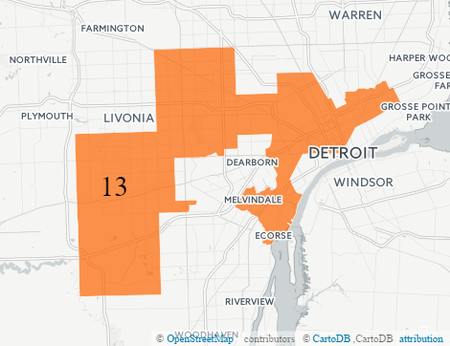
Well, here's what one gerrymandered map looks like - Michigan's 13th district. So, for non-gerrymandered, make it look nothing like this. Originally Posted by Johnnny5
-
November-08-18, 08:26 AM #13
DetroitYES Member
- Join Date
- Mar 2009
- Posts
- 1,355
Originally Posted by archfan
Originally Posted by archfan
The blame for the ridiculousness of the boundary lines surrounding District 13 & 14 lies in Washington, not in Lansing [[And it definitely is not set that way for the benefit of Republicans). Unfortunately, crazy map boundaries such as this are likely to become more common with the new commission based system, not less.
-
November-08-18, 01:22 PM #14
DetroitYES Member
- Join Date
- Sep 2011
- Posts
- 772
I would love to hear how Washington is responsible for those districts looking that way and not Lansing. Specifically. Originally Posted by Johnnny5
Also, how is it NOT to the benefit of Republicans to pack Democrats into two districts [[MI-13 and MI-14) that are D+30 and D+31 respectively? That's exactly how Republicans were able to maintain edges in MI-8 and MI-11 [[both R+4 districts) until two days ago.
-
November-09-18, 03:40 PM #15
DetroitYES Member
- Join Date
- Mar 2009
- Posts
- 396
Nope, the blame resides squarely in Lansing. Why else would Bob LaBrant write an email, Weve spent a lot of time providing options to ensure we have a solid 9-5 delegation in 2012 and beyond. Originally Posted by Johnnny5
https://www.bridgemi.com/public-sector/emails-suggest-republicans-gerrymandered-michigan-weaken-dem-garbage
Nobody in Lansing [[R- or D-) has clean hands. Don't pass the blame over to Washington.
-
November-09-18, 06:04 PM #16
DetroitYES Member
- Join Date
- Mar 2009
- Posts
- 1,355
Originally Posted by Johnnny5
The blame for the ridiculousness of the boundary lines surrounding District 13 & 14 lies in Washington, not in Lansing [[And it definitely is not set that way for the benefit of Republicans). Unfortunately, crazy map boundaries such as this are likely to become more common with the new commission based system, not less.
Originally Posted by RO_Resident
My post refers specifically to the lines surrounding districts 13 & 14.
https://www.washingtonpost.com/news/...=.e070893ac8da
-
November-18-18, 03:35 PM #17
DetroitYES Member
- Join Date
- Sep 2009
- Posts
- 309
Well, actually, the lines for the 13th and 14th were drawn that way to benefit the Republicans. The idea with gerrymandering is to draw a few districts that vote overwhelmingly for your opponents while drawing a bunch that are sufficiently on your side to vote for your party in all but the worst situations for your party. So, for Republicans, the challenge was to design 5 districts that would never ever vote Republican while making 9 districts that were, say, 60-65% Republican. The idea with the 13th and 14th was to corral all of the African-American and Democratic voters in sight into these two districts to keep them out of the 11th district in particular, and make the 11th more likely than not Republican. Well, the "or not" for the 11th happened this year, but not for lack of trying by the Republicans. Originally Posted by Johnnny5

 Reply With Quote
 Posting Permissions
Instagram
DetroitYES navigation
DetroitYES Management
© AtDetroit LLC 2000 - 2024 unless otherwise specified. Please notify us of uncited proprietary content.
Welcome to DetroitYES! Kindly Consider Turning Off Your Ad BlockingX
DetroitYES! is a free service that relies on revenue from ad display [regrettably] and donations. We notice that you are using an ad-blocking program that prevents us from earning revenue during your visit.
Ads are REMOVED for Members who donate to DetroitYES! [You must be logged in for ads to disappear]
Ads are REMOVED for Members who donate to DetroitYES! [You must be logged in for ads to disappear]
DONATE HERE »
And have Ads removed.
And have Ads removed.
Bookmarks