


I just started on a multi-part map series of my own Straits Light Rail, which is basically a regional version of the proposed M-1 Light Rail project. It has eleven lines, seven of which terminate in downtown Detroit and like Chicago and Cleveland, each line has a color name. Three lines, specifically the Red Line [[Woodward), Blue Line [[Gratiot) and Green Line [[M-59) operate local and express services at all times, with the expresses only stopping every one mile [[except when the station spacing is that far apart). The system gets it's name from the straits of Detroit, commonly known as the Detroit River. I used the 2010 Transit Plan map [[even though the existing bus routes on that map are untouched from the 2001 version!) on SEMCOG's website as the basis. It was also inspired by a Woodward light rail map posted on the old forums a few years back. In case you can't find it, this is the thread it was posted in.
I have only released one map so far, it shows the routing of the lines that terminate in downtown Detroit, similar to Chicago's "L" downtown Loop. Several more will be posted, each showing the individual lines outside of the downtown loop. I don't know if it's ever gonna happen in real life, but feel free to comment on this anyway.
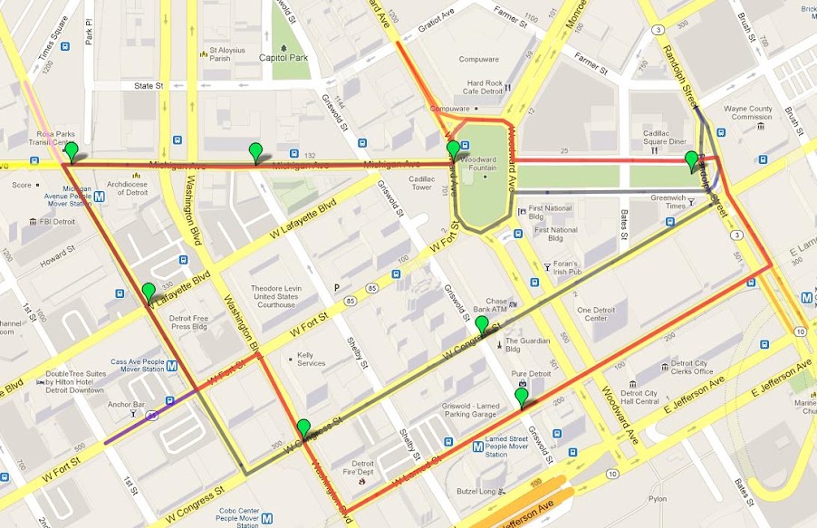
And if your computer can't be able to load that map, I have posted a screenshot of it. The green pins are the stations.
UPDATE: Maps for the Red, Blue and Green Lines [[the three most important lines) are now completed.
Results 1 to 9 of 9
-
January-11-13, 07:58 PM #1
 DetroitYES Member
- Join Date
- Feb 2010
- Posts
- 1,630
 Straits Light Rail - My Version of M-1 Rail, but throughout the Metro Area!
Last edited by mtburb; January-12-13 at 06:53 PM.
-
January-12-13, 08:26 PM #2
DetroitYES Member
- Join Date
- Jan 2011
- Posts
- 417
I took some time to develop a subway/elevated transit system for the city of Detroit. I don't have a map of it and the system is quite extensive. My system uses the people mover to turn trains in the nature of the Chicago L, where lines start at terminals in outer neighborhoods and come downtown and use the loop to turn around and go back.
All trains except the blue line use the existing People Mover tracks to turn around downtown.
Red Line [[Woodward Avenue): Route starts at the State Fairgrounds at 8 Mile and Woodward. Travels down Woodward to Temple Street where it curves to the west over Temple to Park Avenue then follows Park Avenue south into downtown passing over the Fisher Freeway [[I-75) and onto the monorail at Park and Bagley then follows the monorail around the circular loop and back to State Fairgrounds. Stops include: State Fairgrounds, 7 Mile, McNicholas, Manchester, Glendale, Calvert, Hazelwood/Holbrook, Grand Blvd./Woodward, Piquette, Warren Avenue/Wayne State, Canfield, MLK Blvd./Mack, Temple, Montcalm, Grand Circus Park, Broadway, Cadillac Center, Greektown, Bricktown, Renaissance Center, Millander Center, Financial District, Joe Louis Arena, Cobo Center, Fort/Cass, Michigan, Times Square. Total: 27 stations. Line operates 24 hours daily.
Blue Line [[Michigan Avenue): Route starts under Metro Airport as a subway and travels as a subway for it's entire route. The route is the only route that does not use the monorail to turn around downtown, instead this route turns around at Campus Martius/Cadillac Square. The route follows Merriman north to Michigan east into downtown Detroit. turns to the north at Evergreen to loop around Fairlane Town Center and back onto Michigan via Southfield Freeway. Stops include: Metro Airport, Ecorse, Van Born, Avon, Middlebelt, Inkster, Beech Daly, Telegraph, Garrison, Fairlane Town Center [[mall hours only, skipped all other hours), Mercury/Dearborn Amtrak Station, Woodworth, Schaefer, Oakman/Miller, Wyoming/Michigan, Lonyo. Martin, Junction, Clark/Michigan, Grand Blvd./Michigan, 14th, Trumbull, Third/Bagley, Cass [[transfer to elevated tracks), Shelby, Campus Martius/Cadillac Square. Total: 26 stations. Line operates 24 hours daily.
Brown Line [[Grand River Avenue): Route starts at Telegraph and Grand River and follows Grand River downtown, line joins the monorail on Bagley follows the circular loop and skips the Times Square station. Stops include: Telegraph, Lahser/McNichols, Evergreen, Fenkell, Greenfield, Schoolcraft, Fullerton/Myers, Wyoming/Grand River, Oakman/Grand River, Livernois, Joy, Grand Blvd./Grand River, Warren/Linwood, 12th/Grand River, Temple/Grand River, Third/Grand River, Cass/Grand River, Bagley/Grand River, Grand Circus Park, Broadway, Cadillac Center, Greektown, Bricktown, Renaissance Center, Millander Center, Financial District, Joe Louis Arena, Cobo Center, Fort/Cass, Michigan. Total: 30 stations. Line operates: 4am-1am daily.
Green Line [[Gratiot Avenue): Route starts at Eastland Center and follows 8 Mile west to Gratiot where it curves to downtown Detroit. Line joins the monorail after turning at Beaubein making all stops in the circular loop, line exits the loops just after the Cadillac Center station curving back onto Gratiot to go outbound. Stops include: Eastland Center [[mall hours only, trains terminate at 8 Mile/Gratiot all other hours and turn in the loop skipping the mall station), 8 Mile/Gratiot, State Fair/Gratiot, 7 Mile/Gratiot, McNichols/Seymour, Houston Whittier, Gunston, Conner, Harper, Van Dyke/Gratiot, Grand Blvd./Warren, Mt. Elliott, Mack/McDougall, Chene, St. Aubin, Rivard, St. Antoine, Greektown, Bricktown, Renaissance Center, Millander Center, Financial District, Joe Louis Arena, Cobo Center, Fort/Cass, Michigan, Times Square, Grand Circus Park, Broadway, Cadillac Center. Total: 30 stations. Line operates: 4am-1am daily.
Orange Line [[Jefferson Avenue): Route starts at Chalmers and Jefferson. Route follows Jefferson east to Alter, turns north on Alter, west on Kercheval, south on Chalmers and west on Jefferson. Follows Jefferson to McDougall turns north on McDougall then west on Lafayette, joins monorail at Beaubein, completes full circle then returns to Chalmers and Jefferson. Route runs as a subway from Chalmers/Jefferson around outer loop [[Jefferson, Alter, Kercheval, Chalmers), then becomes elevated after Conner. Stops include: Chalmers/Jefferson, Conner/Jefferson, St. Jean/Conner Creek, Cadillac Blvd./Jefferson, Van Dyke/Jefferson, E. Grand Blvd./Jefferson, Mt. Elliott [[station is on Mt. Elliott between Jefferson and Lafayette), Chene/St. Aubin, Bricktown, Renaissance Center, Millander Center, Financial District, Joe Louis Arena, Cobo Center, Fort/Cass, Michigan, Times Square, Grand Circus Park, Broadway, Cadillac Center, Greektown. Total: 21 stations. Line operates: 4am-1am daily.
Silver Line [[Fort Street): Route starts at Fort and Miller in southwest Detroit. Follows Fort to Cass where it joins the monorail downtown, this line does not stop at the Fort/Cass stop, only line other than the Blue Line not to stop at Fort/Cass. Stops include: Miller/Fort [[stop is between Miller and Dearborn), Lawndale/West End, Dragoon/Livernois, Clark/Fort, 14th/Fort, Trumbull/Fort, Third/Fort, Michigan/Cass, Times Square, Grand Circus Park, Broadway, Cadillac Center, Greektown, Bricktown, Renaissance Center, Millander Center, Financial District, Joe Louis Arena, Cobo Center. Total: 19 stops. Line operates: 4am-1am daily.
Total: 153 stations.
-
January-12-13, 08:39 PM #3
DetroitYES Member
- Join Date
- Mar 2009
- Posts
- 2,200
What's the point of the M-59 line?
-
January-12-13, 09:25 PM #4
DetroitYES Member
- Join Date
- Dec 2011
- Posts
- 1,421
Whats the point of 24hrs a day?
-
January-12-13, 09:44 PM #5ArmDetroit Guest
So what about the west side?
 Originally Posted by mtburb

-
January-12-13, 10:32 PM #6
DetroitYES Member
- Join Date
- Feb 2010
- Posts
- 1,630
Finally made a map of the Yellow Line, which serves the west side: http://goo.gl/maps/dDReK Originally Posted by ArmDetroit
Last edited by mtburb; January-12-13 at 10:58 PM.
-
January-12-13, 11:19 PM #7
DetroitYES Member
- Join Date
- Apr 2009
- Posts
- 402
There is no point. Just a nod to the Mt. Clemens / Pontiac crowd. Originally Posted by Novine
Now if someone were serious, they may include an 8 mile crosstown run.
-
January-13-13, 03:09 AM #8
DetroitYES Member
- Join Date
- Mar 2009
- Posts
- 2,104
Yeah, not sure the "green line" would work out so well. I'd remove it from the concept. Transit works best in North American cities when all lines link at least on one end to major downtown area and on the other end a very important park and ride spot, airport, or suburban job center.
This is actually just one reason the circle line in Chicago isn't being considered anymore. It made cross-town commuting way more convenient, but it wouldn't be as robust in ridership as all the other lines that head right downtown. So now BRT will be swapped in its place despite the budget Chicago is proposing would probably be just as expensive as LRT. Perhaps the Green Line would be best as BRT. M-59 is certainly wide enough to have dedicated lanes.
Both the yellow and red lines make most sense to me as far as Detroit's immediate needs. You have access to the airport and touch population centers in Dearborn while perhaps boosting growth and development in areas along Michigan Avenue. And of course, the red line makes practical sense because of density and growth along Woodward
-
January-13-13, 10:39 AM #9
DetroitYES Member
- Join Date
- Feb 2010
- Posts
- 1,630
Just made a new map, this one show the other Metro Airport line, it's also the closest the system gets to my house!

 Reply With Quote
 Posting Permissions
Instagram
DetroitYES navigation
DetroitYES Management
© AtDetroit LLC 2000 - 2024 unless otherwise specified. Please notify us of uncited proprietary content.
Welcome to DetroitYES! Kindly Consider Turning Off Your Ad BlockingX
DetroitYES! is a free service that relies on revenue from ad display [regrettably] and donations. We notice that you are using an ad-blocking program that prevents us from earning revenue during your visit.
Ads are REMOVED for Members who donate to DetroitYES! [You must be logged in for ads to disappear]
Ads are REMOVED for Members who donate to DetroitYES! [You must be logged in for ads to disappear]
DONATE HERE »
And have Ads removed.
And have Ads removed.
Bookmarks