


While looking at WSU virtual motor city for Civil Defense photo's.
I came across this siren photo.
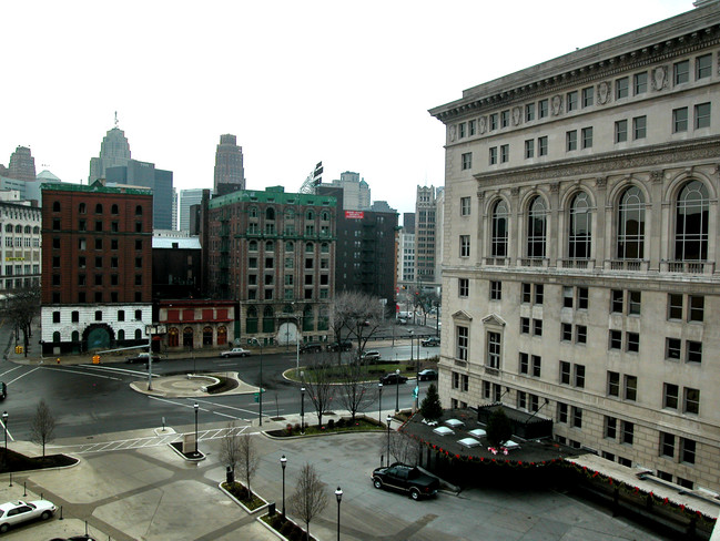
Hudsons is in the back ground, this may be before WWII.
And this would be on the west side of Woodward?
Is this the rooftop of old city hall?
Results 1 to 25 of 35
Thread: A little location help needed
-
January-10-10, 12:32 AM #1
 DetroitYES Member
- Join Date
- Apr 2009
- Posts
- 122
 A little location help needed
-
January-10-10, 12:42 AM #2
DetroitYES Member
- Join Date
- Mar 2009
- Posts
- 732
Not City Hall as the details on the building do not match but I would guess you are in the right vicinity based on the angle of Hudson's..
-
January-10-10, 02:19 AM #3
DetroitYES Member
- Join Date
- Jul 2009
- Posts
- 4,859
I wonder if that's Fire Headquarters.
-
January-10-10, 02:57 AM #4
DetroitYES Member
- Join Date
- Mar 2009
- Posts
- 987
Nope. There's the Stott Building in the background, so I think this photo is looking southwest. Originally Posted by Meddle

-
January-10-10, 03:39 AM #5
DetroitYES Member
- Join Date
- Jul 2009
- Posts
- 4,859
Is that the one on the left edge of the picture or the one behind Hudson's? I'm trying to get my bearings, I don't remember how Hudson's was oriented.
-
January-10-10, 04:09 AM #6
DetroitYES Member
- Join Date
- Jul 2009
- Posts
- 4,859
If I have the angle of view any where near correct, it could be either the old Fire Central Office where I placed the red "X" or possibly Police Headquarters where flame symbol is.
-
January-10-10, 08:01 AM #7
DetroitYES Member
- Join Date
- Mar 2009
- Posts
- 3,990
This might not make sense from trying to imagine sight lines, but it appears the building next to the roof is the DAC.
http://www.metrodmc.com/images/building1.jpg
Now, I agree the sight lines seems crazy, so the question is what other building downtown is built like the DAC?Last edited by gnome; January-10-10 at 08:03 AM.
-
January-10-10, 08:17 AM #8
DetroitYES Member
- Join Date
- Jul 2009
- Posts
- 4,859
The appearance seem to match, but was there a building next door tall enough to match the height in the OP's picture which is only one or two floors less? OP's picture was probably taken sometime in the 50's, so what was built or demolished that might fit?
I'm not familiar enough with DAC's location in relation to possible sight lines.
-
January-10-10, 08:33 AM #9
DetroitYES
- Join Date
- Feb 2009
- Posts
- 6,828
It was taken from the roof of the DAC parking lot. j/k However this picture, which was taken from that location, appears very close. We need our building sleuths to inform us as to what former building stood to the east of the DAC. I believe you can also see a bit of the top of the Lennox in the picture above.
-
January-10-10, 08:42 AM #10
DetroitYES Member
- Join Date
- Jul 2009
- Posts
- 4,859
OK, let's try this. If I have the spots marked right, it could have been a building just east of DAC.
1. Stott
2. Penobscot
3. Hudson's
4. DAC
-
January-10-10, 09:11 AM #11
DetroitYES Member
- Join Date
- Mar 2009
- Posts
- 3,990
Lowell, I believe the building you are asking about was called The Elms. It was a 3 or four story apartment that was bought by the DAC and torn down in about 1986 or 87. It was a shame because the place was fully occupied by young professional types who worked downtown.
The thing that throws me off about the original B&W shot ... it appears that the two buildings are cheek and jowel to one another; that certainly was not the case with The Elms and the DAC. IIRC there was a street between the two of them.
-
January-10-10, 09:24 AM #12
DetroitYES Member
- Join Date
- Mar 2009
- Posts
- 561
Randolph Street used to continue NNW just east of the DAC. The Roycourt Apartments, 1720 Randolph, were on the NE corner of Madison. It was a charming ~4 story U-shaped building with several stairwells opening off the narrow courtyard. Next at 1726 Randolph was the Newark Apartment Hotel. Then came the DAC Garage and finally, the Grand Circus Garage completed the block at Adams.
I don't remember anything of the block except for the Roycourt. It was vacated and torn down for the new DAC Garage.
-
January-10-10, 09:30 AM #13
DetroitYES Member
- Join Date
- Jul 2009
- Posts
- 4,859
Yeah, I know, but that could be an illusion from the camera angle. Originally Posted by gnome
-
January-10-10, 09:38 AM #14
DetroitYES Member
- Join Date
- Apr 2009
- Posts
- 226
Now, who can identify the civil defense siren? I recall reading that Chrysler had one of its many sidelines in the building of these things, and that the loudest one ever produced was in the mid-1950's, powered by a Hemi. This looks older than that. If we could see more of the truck, or read the license plate, it could be dated. My guess is early WWII.
-
January-10-10, 10:49 AM #15
DetroitYES Member
- Join Date
- Mar 2009
- Posts
- 3,990
Thank you NeilR, guess my memory might be fading. Yes, the Roy Court were very charming places. Nicely appointed and built to allow as much natural light into each unit. A lot of built in bookshelfs and cabinets with leaded glass fronts. Coffered ceilings and tiny kitchens.
Of course since I remembered the wrong name, maybe I have this memory mixed up as well.
-
January-10-10, 11:02 AM #16
DetroitYES Member
- Join Date
- Mar 2009
- Posts
- 3,990
Attachment 4757
found this pic at this site: http://www.placepromo.com/display.ph...+-+MI&page=112
Seems strange that Detroit is promoting a building that doesn't exist, but then again ...
EDIT: that site listed above is pretty interesting and worth a check out. Here is a pic of the old DAC garage on which the siren might have sat:
http://www.placepromo.com/display.ph...+-+MI&page=113Last edited by gnome; January-10-10 at 11:06 AM.
-
January-10-10, 12:19 PM #17
DetroitYES Member
- Join Date
- Mar 2009
- Posts
- 2,166
Old DAC garage. Chrysler siren.
-
January-10-10, 12:19 PM #18
DetroitYES Member
- Join Date
- Mar 2009
- Posts
- 1,370
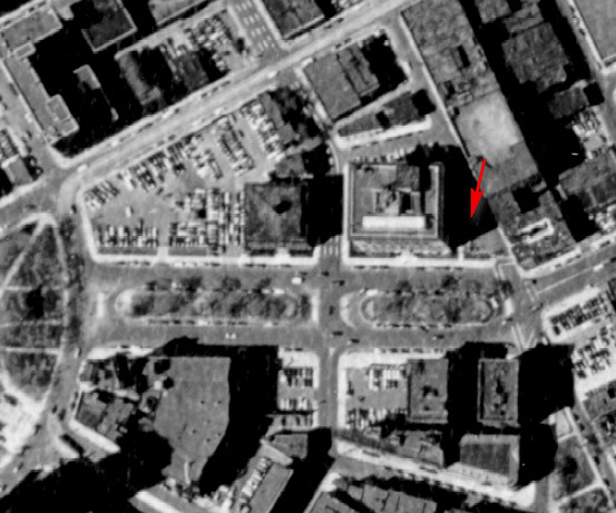
Here's a 1930 map of that area:

It's from this map segment. Here's the entire set of map segments, courtesy of fellow forumer Hornwrecker.
Here is the page from the 1928 Detroit City Directory for this portion of Randolph. Note the type setting error in the name of the ROYCOURT APTS on this map. The cap "X" and "Y" are side by side in the California Job Case [h/t to Jimaz].
-
January-10-10, 12:25 PM #19
DetroitYES
- Join Date
- Feb 2009
- Posts
- 6,828
1949 CULMA map -- So it appears it was from the old DAC parking lot after all? That would make sense; it would be the only place to provide access for the truck and have the weight bearing ability for it to drive on.
-
January-10-10, 12:36 PM #20
DetroitYES Member
- Join Date
- Mar 2009
- Posts
- 2,166
Exactly.
The original with the background detail:
Attachment 4765
The view, clockwise, to the Penobscot, Hudsons, Stott.
Attachment 4766
-
January-10-10, 12:44 PM #21
DetroitYES Member
- Join Date
- Mar 2009
- Posts
- 3,990
Good work guys. Always impressive.
-
January-10-10, 12:58 PM #22
DetroitYES
- Join Date
- Feb 2009
- Posts
- 6,828
Now that Gnome had pounded the gavel on this thread, I have side curiosity. Was there ever a building on the outer ring NE corner of Grand Circus Park, just south of the old YMCA? Was this the first missing tooth in the smile or was it always a parking lot?
-
January-10-10, 01:17 PM #23
DetroitYES Member
- Join Date
- Mar 2009
- Posts
- 3,990
in the LOC you can find a couple of 360 panoramic shots of GPC.
here is one taken on the east side of woodward:
http://lcweb2.loc.gov/cgi-bin/query/...i,lamb,hec,krb,
-
January-10-10, 01:21 PM #24
DetroitYES Member
- Join Date
- Mar 2009
- Posts
- 874
That's a great question. The earliest aerial photographs show it has always been parking, but there may have been some structures that predated the photos. Originally Posted by Lowell
-
January-10-10, 01:28 PM #25
DetroitYES Member
- Join Date
- Mar 2009
- Posts
- 2,166
Nothing since the 19th century homes were removed.

 Reply With Quote
 Posting Permissions
Instagram
DetroitYES navigation
DetroitYES Management
© AtDetroit LLC 2000 - 2024 unless otherwise specified. Please notify us of uncited proprietary content.
Welcome to DetroitYES! Kindly Consider Turning Off Your Ad BlockingX
DetroitYES! is a free service that relies on revenue from ad display [regrettably] and donations. We notice that you are using an ad-blocking program that prevents us from earning revenue during your visit.
Ads are REMOVED for Members who donate to DetroitYES! [You must be logged in for ads to disappear]
Ads are REMOVED for Members who donate to DetroitYES! [You must be logged in for ads to disappear]
DONATE HERE »
And have Ads removed.
And have Ads removed.
Bookmarks