


Why? Snow and ice, of course. Grand Rapids, or Detroit, are certainly no San Fran.Originally Posted by Sandhouse

Results 51 to 61 of 61
Thread: Remnants of a streetcar system
-
December-17-10, 12:46 PM #51Vox Guest

-
December-17-10, 01:53 PM #52
 DetroitYES Member
- Join Date
- Apr 2009
- Posts
- 115
Actually, there was an attempt [[or a proposal) to build a cable-car line up Woodward Avenue. In 1891, the Detroit Street Railway Company sought a 30-year extension to their franchise so that they could electrify their lines. That franchise extension included the building of a Woodward cable-car line. Even though the Common Council approved it, Mayor Hazen Pingree felt that the franchise the company sought was illegal and the overall proposal did not benefit the citizens of Detroit, so he vetoed it. By the time electric power was installed later the next year the electric overhead trolley system was chosen city-wide. Originally Posted by Sandhouse
-
December-17-10, 02:06 PM #53
DetroitYES Member
- Join Date
- Jan 2010
- Posts
- 4,867
Being flat, Detroit didn't have the pressing need to convert horse car lines to cable. There was just a brief window before electric cars became the best choice and cable cars became obsolete. The capital cost and maintenance cost diiferentials of cable versus electric were significant. Originally Posted by Detroitnerd
-
January-04-11, 09:18 PM #54DetroitDad Guest Taken For A Ride
http://westenddumplings.blogspot.com...1_archive.html
Taken For a Ride is a 1996 documentary about the dismantling of North America's early mass transit systems. From 5 min to about 25 min deals mainly with streetcars and has some great footage of the old systems in action.

An interesting quote from one of the newsreel-style promo pieces from G.M. in the mid 1950's:
"Before the big change, all but 6 of the city's main arteries are handicapped by streetcar operations..."
Winnipeg, too, got rid of it's streetcar system in that same era and sold off the fleet for $100 a pop.
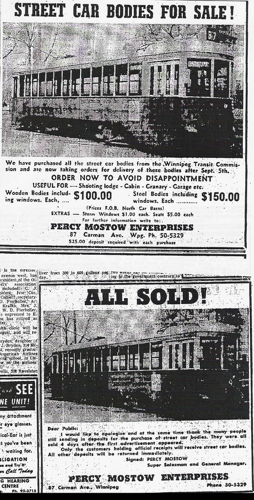
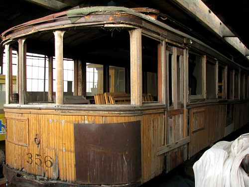
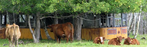
There's only one known to be left intact, 356 [[see below), though the odd decaying body can can be found in cottage country and farmer's fields such as 680 near Inwood [[at bottom).
-
January-04-11, 10:03 PM #55
DetroitYES Member
- Join Date
- Feb 2010
- Posts
- 4,221
Good job Ddad!
-
January-04-11, 10:03 PM #56citylover Guest Must we.........
go thru this myth again?
-
January-04-11, 11:32 PM #57
DetroitYES Member
- Join Date
- May 2009
- Posts
- 231
Check this website for everything you ever wanted to know about DSR-DDOT:
http://finance.groups.yahoo.com/group/DSR-2-DOT/
-
January-05-11, 02:38 PM #58
DetroitYES Member
- Join Date
- Jun 2009
- Posts
- 402
Was was the terminus of streetcars on Detroit NE side?...
Where did they end on streets like Mack and Harper? Is there a map of Detroit that shows the streetcar lines?
-
January-05-11, 07:44 PM #59DetroitDad Guest Cross Posts
Cross post to Photos of DSR Street Car Lines.
-
January-05-11, 09:35 PM #60
DetroitYES Member
- Join Date
- Jan 2010
- Posts
- 4,867
On the east side, the Harper line went as far as shoemaker where it turned south toward the St jean car house. Originally Posted by Al Publican
The Warren line went east to Barham.
Mack and Charlevoix lines terminated at Alter Road.
Kercheval line ended at St Jean.
Gratiot streetcar line ended at 7 Mile, though the interurban went all the way to Port Huron on that line. After the end of the interurban, the street car went to Mt Clemens for a few years.
Jefferson streetcar line ended at Wayburn, but the interurban went through the Grosse Pointes to Mt Clemens.
-
January-06-11, 11:07 AM #61
DetroitYES Member
- Join Date
- Mar 2009
- Posts
- 2,166
The Warren extention off of the Mack line [[on E Warren from Anderdon to Barham) was abandoned in 1946. The rest of the Mack line [[up Gratiot to Mack to Alter) was discontinued in 1947. Originally Posted by Al Publican
The Crosstown line, which ran on E Warren from St Jean to Cadillac to E Forest to 14th and westward, was discontinued in 1946.
The Charlevoix line, which ran on Charlevoix from Alter to McDougal, up to Mack and westward, was discontinued in 1949.
The Clairmount line, which started at E Jefferson and St Jean, ran up St Jean to Shoemaker to Montclair to Harper to Mt Elliot and westward, was discontinued in 1951.
The Fort-Kercheval line, which ran on Kercheval westward from Lycaste, was discontinued in 1949.
The Harper line, which ran from 8 Mile down Van Dyke to Harper to Mt Elliot to Forest to Hastings, was discontinued in 1947.
The Mt Elliot line, which zig-zagged on Chene, Mt Elliott, McDougal, and Van Dyke, ws discontinued in 1951.
The Baker line, which on the eastside ran on Nevada west from Van Dyke, to Mt Elliot, to Davison, to Jos Campau, to Chene, was discontinued in 1952.
The Jefferson line was discontinued in 1954.
That covers most of the eastern side of the system.

 Reply With Quote
 Posting Permissions
Instagram
DetroitYES navigation
DetroitYES Management
© AtDetroit LLC 2000 - 2024 unless otherwise specified. Please notify us of uncited proprietary content.
Welcome to DetroitYES! Kindly Consider Turning Off Your Ad BlockingX
DetroitYES! is a free service that relies on revenue from ad display [regrettably] and donations. We notice that you are using an ad-blocking program that prevents us from earning revenue during your visit.
Ads are REMOVED for Members who donate to DetroitYES! [You must be logged in for ads to disappear]
Ads are REMOVED for Members who donate to DetroitYES! [You must be logged in for ads to disappear]
DONATE HERE »
And have Ads removed.
And have Ads removed.
Bookmarks