


North Farmington, Woodcreek Farms, Westwood
Attachment 6049
Results 76 to 100 of 168
Thread: Small Towns around Detroit
-
May-11-10, 09:33 PM #76
 DetroitYES Member
- Join Date
- Mar 2009
- Posts
- 2,166

-
May-11-10, 09:38 PM #77
DetroitYES Member
- Join Date
- Mar 2009
- Posts
- 2,166
Preston, Hand, Penford, Eureka
Attachment 6050
-
May-11-10, 10:46 PM #78
DetroitYES Member
- Join Date
- Jul 2009
- Posts
- 244
Actually Fort Street runs north-south. Southfield runs east-west. We had this discussion at a meeting today. I'm used to Southfield running north-south having grown up in Oakland County. It took me a long time to understand all of this stuff. Originally Posted by wilderness

-
May-12-10, 05:52 AM #79
DetroitYES Member
- Join Date
- Mar 2009
- Posts
- 2,200
Woodcreek Farms was actually an incorporated Village in Farmington Township, as compared to most places you've listed that were unincorporated. It, the Village of Quakertown and the remainder of Farmington Township, incorporated as the City of Farmington Hills in the early 1970s.
-
May-12-10, 08:59 AM #80
DetroitYES Member
- Join Date
- Mar 2009
- Posts
- 2,166
Farmington Hills area, before annexation:
Attachment 6051
From "Profile of a Metropolis", Robert Mowitz, Deil Wright, 1962
-
May-12-10, 11:22 AM #81littlebuddy Guest
MikeM, nice map. I like seeing Hazel Park as just a dot on a road, the same with Madison Hts. Must be an old map. Thanks
-
May-12-10, 11:29 AM #82
DetroitYES Member
- Join Date
- Mar 2009
- Posts
- 2,200
Nice finds Mike. Farmington did annex further west along Grand River before Farmington Hills was incorporated. You can see that in this map:
http://www.ci.farmington.mi.us/farmmap.htm
I've read that Farmington Hills incorporated in reaction to a threat of either Novi or Farmington to annex the industrial area in the 275/Grand River vicinity but I've never seen anything in print that confirms that.
-
May-12-10, 11:29 AM #83littlebuddy Guest
Where could you buy old maps like you have MikeM?
-
May-12-10, 11:35 AM #84
DetroitYES Member
- Join Date
- Jan 2010
- Posts
- 101
Someone mentioned earlier about the differences in the street grids about town. I'm most familiar with this, being a native eastsider. The streets extending inland from the river were based on property lines at the time. "Ribbon farms" etc. I enjoy studying old maps from the 1800's. You can tell where the current streets were then, even if they didn't have a name yet. Morang, Moross, Kelly, etc. Very cool stuff, I think.
-
May-12-10, 11:37 AM #85
DetroitYES Member
- Join Date
- Mar 2009
- Posts
- 2,166
eBay, antique stores, used book stores. Originally Posted by littlebuddy
-
May-12-10, 11:43 AM #86
DetroitYES Member
- Join Date
- Jan 2010
- Posts
- 101
Is there any way someone could find out specific info on that old "farm-like" house on Gratiot we were discussing earlier? Year built? Original owner, etc? Looked like from the photo it's boarded up. It would be kind of a shame if they got rid of it.
-
May-12-10, 11:50 AM #87
DetroitYES Member
- Join Date
- Jan 2010
- Posts
- 101
Also, has anyone ever noticed another former old homestead on the west side of Van Dyke, just south of 8 mile rd.? It's also a relic.
-
May-12-10, 12:37 PM #88
DetroitYES Member
- Join Date
- Jul 2009
- Posts
- 244
Interesting. I didn't know that. I'm from the southwest corner of Farmington Hills. I've heard about Quakertown. Originally Posted by Novine
Lincoln Park was known as Quandt'sCorner's prior to being incorporated as the Village of Lincoln Park in 1921. Herman Quandt ran the tavern and his house was next door to it. The house and tavern were moved when Fort Park was cut through in 1925. The house was moved to Fort Park. A friend lives in it now. The tavern still exists but has been long forgotten. The tavern is probably the oldest commercial building in the city of Lincoln Park.
-
May-12-10, 12:44 PM #89
DetroitYES Member
- Join Date
- Jul 2009
- Posts
- 244
What city is this house in? Is it in Eastpointe? If so, I know the mayor of Eastpointe, Suzanne Pixley. She's on the Macomb County Historical Commission with my mom. I can ask Suzanne what she knows about this house. Originally Posted by FerndaleDamon
-
May-12-10, 12:51 PM #90
 DetroitYES Member
- Join Date
- Mar 2009
- Posts
- 5,854
It's in Detroit, south of 8 Mile Originally Posted by lalynch
-
May-12-10, 01:05 PM #91
DetroitYES Member
- Join Date
- Jan 2010
- Posts
- 101
Like jcole said. There's a pic of it on the previous page. Sits next to a Taco Hell on Gratiot bet. State Fair/ 8 mi. Maybe I should tempt fate and try to see the address. That might help.
-
May-12-10, 01:15 PM #92
DetroitYES Member
- Join Date
- Mar 2009
- Posts
- 5,854
It's between 15146 Gratiot and 15170 Gratiot. That's Lucky's II and Taco Bell's addresses. It sits very close to Lucky's so I'm guessing the address is in the 15150-160 range. I wonder if the bar owns the property the house sits on.Look here.
Lucky II Lounge
-
May-12-10, 02:00 PM #93
DetroitYES Member
- Join Date
- Jan 2010
- Posts
- 101
Maybe, jcole. Now I'm curious. I guess I'll have to make this my detective assignment!

-
May-12-10, 02:44 PM #94
DetroitYES Member
- Join Date
- May 2009
- Posts
- 250
Early 70's Novi was no annexation threat to Farmington Twp. Novi was a new city [[1969) and really had plenty of available land for growth anyways. 12 Oaks was a big bonus for the new city. At the time, downtown only had a hotel/bar, a gas station, a Bates Hamburger, and a small strip mall. The rest of downtown along Grand River was old houses converted into storefronts. And Novi's eastern boundary was Haggerty, a mile from the Halstead Rd Industrial Park. Originally Posted by Novine
Farmington, on the other hand, wanted more commercial and industrial tax revenue. The city was basically a bedroom community with a downtown, and stores along Grand River. That's why Farmington annexed a 'sliver' of land southward to 8 Mile Rd. They offered the developer services the township could not provide at the time. Farmington Twp learned from that loss, and used everything they had to offer to developers of the Industrial Park at Grand River/ Halstead/ I-96. Meanwhile, City of Farmington annexed further westward along Grand River, getting very close to Halstead Rd. This was one of the biggest points mentioned to promote township's city incorporation.
BTW- that little sliver of land going down Farmington Rd was a cash cow for the city. All the new businesses at the interchange, and- bonus- about 1/2 mile or so of I-96[[former 96) freeway was now in the city. [[speed trap)
-
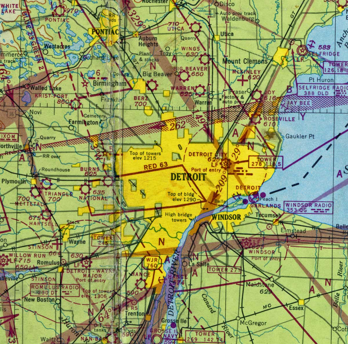
May-12-10, 03:13 PM #95
DetroitYES Member
- Join Date
- Mar 2009
- Posts
- 2,166
Here are parts of two aeronautical charts of the Detroit area - one from 1946 and the other from 2004. The yellow shading represents densely populated areas and supposedly replicates the nighttime lighting pattern a pilot would see from above. They illustrate the change the OP mentions at the start of the thread.

-
May-12-10, 04:14 PM #96
DetroitYES Member
- Join Date
- Mar 2009
- Posts
- 2,200
"Early 70's Novi was no annexation threat to Farmington Twp. Novi was a new city [[1969) and really had plenty of available land for growth anyways."
True enough that Novi had plenty of land. But one of the potential motivators for annexation was the construction of I-275 through the west side of then Farmington Township. It's planned route left a small slice of the Township between the freeway and Novi. I could have seen Novi officials seeing that land as an easy target for annexation. I've read that Ed McNamara, who was then Mayor of Livonia, had the route for I-275 adjusted so that the land on either side of the freeway was within the Livonia borders. Not sure if that's myth or fact but seems to be consistent with the route of the freeway.
-
May-12-10, 04:19 PM #97
DetroitYES Member
- Join Date
- Mar 2009
- Posts
- 2,166
Farmington area, 1970:
Attachment 6061
Detroit area, 1902:
Attachment 6062
-
May-12-10, 04:36 PM #98
DetroitYES Member
- Join Date
- Jan 2010
- Posts
- 4,867
Originally Posted by MikeM
I think that most of those places named as "dots" on the map represented post offices.
I had forgotten about "Waldenburg" in Macomb County.
-
May-12-10, 04:48 PM #99
DetroitYES Member
- Join Date
- May 2010
- Posts
- 342
Any idea what "RAP. RY. [[ELEC.)" stands for - is it an electric street car along Gratiot that went all the way to Mt. Clemens?
And what is "Milk Ri*" above the Grosspointes indicating?
-
May-12-10, 04:51 PM #100
DetroitYES Member
- Join Date
- Mar 2009
- Posts
- 2,166
Rapid Railway, the name of the interurban running up Gratiot to Port Huron.
Milk River, outlet to Lake St Clair between 8 & 9 Mile Rds.

 Reply With Quote
Tags for this Thread
 Posting Permissions
Instagram
DetroitYES navigation
DetroitYES Management
© AtDetroit LLC 2000 - 2024 unless otherwise specified. Please notify us of uncited proprietary content.
Welcome to DetroitYES! Kindly Consider Turning Off Your Ad BlockingX
DetroitYES! is a free service that relies on revenue from ad display [regrettably] and donations. We notice that you are using an ad-blocking program that prevents us from earning revenue during your visit.
Ads are REMOVED for Members who donate to DetroitYES! [You must be logged in for ads to disappear]
Ads are REMOVED for Members who donate to DetroitYES! [You must be logged in for ads to disappear]
DONATE HERE »
And have Ads removed.
And have Ads removed.
Bookmarks