


This might be it [[Oakfield north of Keeler). These are rather cute little houses. I installed phones in several of them back in a former life about 30 years ago.Originally Posted by Meddle

http://maps.google.com/maps?f=q&sour...=12,82.25,,0,5
Results 51 to 75 of 86
Thread: Unusual Detroit Streets Thread
-
March-09-10, 08:28 PM #51
 DetroitYES Member
- Join Date
- Mar 2009
- Posts
- 158

-
March-09-10, 08:34 PM #52
DetroitYES Member
- Join Date
- Mar 2009
- Posts
- 4,317
How neat is that? That one takes the cake so far.
-
March-09-10, 09:51 PM #53
DetroitYES Member
- Join Date
- Mar 2009
- Posts
- 45
Your dead on there Detroitnerd. Looking up some plat info the alley that backs Bessemore in fact has an alley along the back in its original plat though it is only platted 7' wide and abuts an unnamed existing road. Given its narrow width I would assume the existing road was just turned into an alley when the adjacent parcel was platted behind Bessemore. Very interesting alley there though Cornbot, perhaps it was at one time named Cooper St? Im going to do some more research and see what I can turn up. Originally Posted by Detroitnerd
Here is a link to the plat.
http://www.dleg.state.mi.us/platmaps..._SUBINDEX=1496
-
March-09-10, 10:32 PM #54
DetroitYES Member
- Join Date
- Mar 2009
- Posts
- 45
I have found something weird which someone with a Sanborn may be able to help with. That Private Claim that those streets are in seems very interesting if you follow it north and south. Seems to be some interesting filled in gaps perhaps it was developed earlier or later than the surrounding lands. Anyways if you go North from Hancock a few blocks to the block bounded by Elwood on the W. Kirby on the N. Moran on the E. and Frederick on the S. Take a look in the middle of the block. The alley opens up quite wide in the middle to about 80' wide or so. In the 1949 aerial you can see a small building in this land locked alley area with a bunch of cars it looks like. Some sort of landlocked garage. I have never seen anything like that before. Anyone know what Private Claim the strip of land bounded by Moran and Elmwood is? Also note the interesting T shaped alleys that are off of the West side of Elmwood as you go N/S Originally Posted by Detroitnerd
Here is the 1949 image
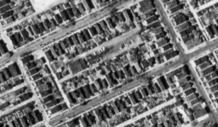
A link to the full size image.
http://www.clas.wayne.edu/photos/par...9/ha-3-147.pdf
The site today a large grassy area.
http://tiny.cc/9PiBx
-
March-10-10, 03:18 AM #55
DetroitYES Member
- Join Date
- Jul 2009
- Posts
- 4,859
Originally Posted by catch22
Yeah, that's probably it. For some reason Archdale stuck in my mind, but that's only a block west. I was all over that area and it really caught me as odd.
-
March-10-10, 03:34 AM #56
DetroitYES Member
- Join Date
- Mar 2009
- Posts
- 872
Wow, very, very cool. A movie set waiting to happen. Location managers would have a ball with this thread. Originally Posted by catch22
-
March-16-10, 06:08 PM #57
DetroitYES Member
- Join Date
- Feb 2010
- Posts
- 1,630
Bondie Street, Wyandotte
The section west of Sixth Street is very unusual though it is not in Detroit. One the south side you have the sides of the houses on the cross streets. On the north side you have the backyards of the houses on Clinton. Very crazy. See the link below. You can see it, but the imagery is older and in low-res. Google has to revisit this area and take hi-res pictures of all the streets, including Bondie.
http://maps.google.com/maps?hl=en&ie...271.07,,1,2.46
Fifth Street
Another example of a Detroit street that has been chopped up by freeway and casino construction.
- Forsyth and Holden: This is the result of building the I-94/M-10 interchange, one of the country's first freeway interchanges. Looking north on Forsyth, you can see lots of double yellow lines in the pavement. Very odd. Plus several Bishop lights still standing on Holden.
- Fifth and Pine: Like Forsyth, this section is the result of the M-10/I-75 interchange [[another early interchange). This is my favorite section of Fifth Street. It's a short one, running from Pine to Temple. A Bishop still stands at Spruce.
-
March-16-10, 06:29 PM #58
DetroitYES Member
- Join Date
- Apr 2009
- Posts
- 67
Electric Street, located in Detroit's 48217 zip code [[the sliver of Detroit extending between Melvindale and River Rouge) is pretty unusual, even by Detroit standards. It is a broad boulevard where the median is a mixture of landscaping and power line right-of-way. It is unusual for a Detroit street because there are no vacant lots and the vast majority of its postwar houses are occupied.
http://maps.google.com/maps?q=electr...237.79,,0,5.42Last edited by boogiechillen; March-16-10 at 06:32 PM.
-
March-16-10, 07:51 PM #59
DetroitYES Member
- Join Date
- Feb 2010
- Posts
- 1,630
Is that the same Electric Street that is in Lincoln Park, Wyandotte and Riverview? Originally Posted by boogiechillen
-
March-16-10, 10:21 PM #60
DetroitYES Member
- Join Date
- Mar 2009
- Posts
- 872
Yep, check out the google map, it kind of meanders around and follows the power lines south into the downriver communities, broken up at points by the regular street grid. a cool find. Originally Posted by mtburb
-
March-16-10, 10:35 PM #61
DetroitYES Member
- Join Date
- Jun 2009
- Posts
- 44
Forgive me if someone's mentioned this already. I recall from my youth a street or two of houses built on a slightly smaller scale than those around them. Doors, windows were a little smaller, houses were a little shorter. I remember driving by at least two different times. We called them the midget houses. They were north of Fenkell [[maybe even north of Six Mile) and slightly east of the Southfield.
Ring any bells?
-
March-17-10, 02:42 AM #62
DetroitYES Member
- Join Date
- Jul 2009
- Posts
- 4,859
See post #51 above.
-
March-17-10, 12:49 PM #63
DetroitYES Member
- Join Date
- Mar 2009
- Posts
- 65
I loved that little group of houses on Oakfield. Would drive through there every so often. Haven't seen them in over 30 years. Next time I am in Detroit I will go see them again now that I have the address. They are so cool. Thanks 22

-
March-18-10, 12:50 PM #64
DetroitYES Member
- Join Date
- Apr 2009
- Posts
- 915
I believe I heard years ago that Electric Street had an electric streetcar line that went from Detroit near Shaefer through a couple of Downriver suburbs. Maybe it had to do with Great Lakes Steel? GLS used to employ over 10,000 people many of whom lived downriver. Originally Posted by boogiechillen
-
March-18-10, 05:35 PM #65
DetroitYES Member
- Join Date
- Apr 2009
- Posts
- 20
How about Hastings St.
-
March-18-10, 09:22 PM #66
DetroitYES Member
- Join Date
- Apr 2009
- Posts
- 78
Schuper St.
Schuper Street is a small street running east from Lakepointe to Barham. It is north of Lakepointe and Frankfort by a 1/2 block. North of that is Southampton Street. Originally Posted by EMG
-
March-19-10, 06:15 PM #67
DetroitYES Member
- Join Date
- Apr 2009
- Posts
- 862
McMillan Elementary School [[1894) was on S. West End. Google street view shows it's been torn down. Sad for one of our few Victorian neighborhoods left.
http://detroit1701.org/McMillanSchool.htm
http://www.insidesouthwest.com/commu...mentary-schoolLast edited by kathy2trips; March-19-10 at 06:19 PM. Reason: misspelling
-
March-19-10, 06:41 PM #68
DetroitYES Member
- Join Date
- Apr 2009
- Posts
- 862
Link to R. L. Polk's Detroit City Directory 1928-29, Fifth Street starts at first column down toward the bottom of the page. Originally Posted by mtburb
http://quod.lib.umich.edu/cgi/t/text...meset;seq=2324
-
March-19-10, 06:53 PM #69
DetroitYES Member
- Join Date
- Mar 2009
- Posts
- 642
The massive urban renewal of the near Eastside obliterated several streets through that area. Originally Posted by mtburb
-
March-21-10, 10:51 PM #70
DetroitYES Member
- Join Date
- Mar 2009
- Posts
- 36
Wow, that one is obscure - unpaved, blocked by debris and a basketball net, and with the street sign at Lakepointe swallowed up by a tree. Originally Posted by wiz40
-
March-21-10, 11:01 PM #71
DetroitYES Member
- Join Date
- Mar 2009
- Posts
- 36
Winchester E [[er, W)
Here's one more curious short street, interesting mostly because the street sign is wrong.
http://tinyurl.com/yznvmby
- Ross in Ottawa
-
March-21-10, 11:41 PM #72The Dude Guest
Just would like to add that Monroe Street hasn't gone east of what is now I375, THE Chrysler Freeway in over 55 years Originally Posted by jams
-
March-22-10, 12:06 PM #73
DetroitYES Member
- Join Date
- Mar 2009
- Posts
- 3,865
I find Joseph Votrobeck and his family living on farmland in Redford Township in the 1900 census. He was born in Austria in 1865. He emigrated to America in 1869 [[with his parents, no doubt) and is naturalized. His wife, Annie, is a year younger than him and was born in Michigan. They have three children. Can't find him in the 1910 census [[name probably mis-spelled by the transcriber), but in 1920 he and his family have moved into Detroit and reside at 146 Maybury Grand Avenue [[old numbering system), and he states he is a carpenter and home builder. Don't have access to the 1930 census, sorry to say. Originally Posted by gazhekwe
-
May-19-10, 08:29 PM #74
DetroitYES Member
- Join Date
- Apr 2009
- Posts
- 78
Originally Posted by 220hendrie1910
Unfortunately, that street sign is correct, as John R. Street is the East West dividing line for Woodward Ave. north of McNichols [[or 6 Mile ).
-
May-19-10, 10:54 PM #75
DetroitYES Member
- Join Date
- May 2010
- Posts
- 122
Ah yes - Barham St. Originally Posted by wiz40
I think the issue with the Lakepoint - Barham strangeness was that this was at one time a boundary between Detroit and Grosse Pointe [[??). At the very least, its the dividing line between developments that were a decade or more apart.
I lived on Bedford near Munich and I recall someone saying that this was at one time not part of Detroit. I also remember hearing that the Barham and Lakepointe was a boundary with Detroit on the west side and something else on the east.
Anyone have access to the history of this area that might yield clues???

 Reply With Quote
 Posting Permissions
Instagram
DetroitYES navigation
DetroitYES Management
© AtDetroit LLC 2000 - 2024 unless otherwise specified. Please notify us of uncited proprietary content.
Welcome to DetroitYES! Kindly Consider Turning Off Your Ad BlockingX
DetroitYES! is a free service that relies on revenue from ad display [regrettably] and donations. We notice that you are using an ad-blocking program that prevents us from earning revenue during your visit.
Ads are REMOVED for Members who donate to DetroitYES! [You must be logged in for ads to disappear]
Ads are REMOVED for Members who donate to DetroitYES! [You must be logged in for ads to disappear]
DONATE HERE »
And have Ads removed.
And have Ads removed.
Bookmarks