


Wow, I'm glad my question generated such interest!
There is an interesting difference between the two maps. The 1876 Wayne County atlas shows the skewed line between lots 30 and 31 corrected once it gets up to lots 34 and 39. But the 1885 map [[is this also Wayne County atlas?) shows it continues in its skewed direction up there. Was the line adjusted sometime during those 9 years or is one of the maps wrong?
A few other things about the two maps don't match either, like the length of lots 28-33.

Results 26 to 42 of 42
Thread: Diagonal alley in Hamtramck
-
March-25-16, 12:46 AM #26
 DetroitYES Member
- Join Date
- Dec 2011
- Posts
- 338

Last edited by Király; March-25-16 at 01:01 AM.
-
March-25-16, 08:09 AM #27
DetroitYES Member
- Join Date
- Nov 2010
- Posts
- 104
I love this thread so much. It's amazing what gets noticed, and the resources people here have to dig back in time!
Related: Read this late last year on how building shapes in LA reflect a streetscape that no longer exists. I'm sure some of you on this thread will enjoy it too:
http://www.bldgblog.com/2015/12/ghos...f-los-angeles/
-
March-25-16, 10:36 AM #28
DetroitYES Member
- Join Date
- Dec 2011
- Posts
- 338
I extended the centerline of the alley with a ruler on my screen up to Gallagher and Trowbridge [Street View], and there is still evidence of it there. The line looks like it would run up right against the houses at the end of the block. The house on the southeast corner is wide enough for a side driveway right on the line. The house on the northeast corner has an addition built right on the line. Originally Posted by 48307

Last edited by Király; March-25-16 at 10:58 AM.
-
March-25-16, 11:59 AM #29
DetroitYES Member
- Join Date
- Dec 2011
- Posts
- 338
Sorry, bad link to Google Street View. Better link to Gallagher and Trowbridge. Originally Posted by Király
-
March-25-16, 04:32 PM #30
DetroitYES Member
- Join Date
- Mar 2009
- Posts
- 1,547
The house with the driveway on the side looks older than the surrounding houses. To me, it always looked like an original farm house our something. I know it's hard to tell. It's plain, and the outside has been redone. But architecurally, it sits on its lot quite differently than the surrounding houses. You might wonder if it's driveway was the old road.
I'll walk the alley this weekend with my camera and see if I see anything.
-
March-25-16, 04:54 PM #31
DetroitYES Member
- Join Date
- May 2010
- Posts
- 342
The 1885 map is from a Detroit atlas which was produced by a different publisher than the Wayne County atlases. Originally Posted by Király
Links for accessing or downloading the atlases at archive.org are in this post:
http://www.detroityes.com/mb/showthr...664#post383664
A link for the 1855 Wayne Co./Detroit map is in this thread:
http://www.detroityes.com/mb/showthr...y-Detroit-Maps
I was only able to find two plats that that include that line, but they show that it did extend to Caniff[[Four Mile).
To see the following plats the java plugin needs to be installed and enabled in your browser.
For lots 37 & 38:
http://www.dleg.state.mi.us/platmaps...C_SUBINDEX=586
For lots 30 & 39:
http://www.dleg.state.mi.us/platmaps...C_SUBINDEX=549
Search site for Michigan plats is here:
http://www.dleg.state.mi.us/platmaps/sr_subs_adv.asp
-
March-25-16, 04:58 PM #32
DetroitYES Member
- Join Date
- Dec 2011
- Posts
- 338
I superimposed MikeM' 1915 Sanborn map with Google's aerial view. Interesting to see how some of the lots line up and how some are off by exactly half a lot. The continuation of the diagonal alley line for the most part lines up.
[deleted image]
EDIT:
Sorry, I made a mistake when overlaying the two images. Here it is fixed and everything lines up:
Original wrong image below:Last edited by Király; March-25-16 at 06:54 PM.
-
March-25-16, 06:38 PM #33
DetroitYES Member
- Join Date
- Jan 2010
- Posts
- 4,867
Just a "maybe" but the guy who owned a large piece might have split his land in two along a diagonal line which represented a ditch or a hedge line and sold one part to another party. Two heirs may have split the land again along some sort of recognizable feature. Originally Posted by Brock7
-
March-25-16, 07:22 PM #34
DetroitYES Member
- Join Date
- Mar 2009
- Posts
- 1,106
The house at the SE corner of Trowbridge and Gallagher [[3112 and 3118 Trowbridge) has always struck me as odd, too. I would concur that it might pre-date the neighborhood. Not sure if this has something to do with the crazy lot lines, but interesting nonetheless.
-
March-26-16, 12:46 AM #35
DetroitYES Member
- Join Date
- Dec 2011
- Posts
- 338
Another overlay shows why the house at 3232 Yemans is narrower than any other on that street.
-
April-06-16, 04:37 PM #36
DetroitYES Member
- Join Date
- Apr 2016
- Posts
- 4
Just curious...How do you attain access to the Sanborn maps?
-
April-09-16, 07:03 PM #37
DetroitYES Member
- Join Date
- Mar 2009
- Posts
- 45
I would guess its just an line that ended up off a few degrees. This is found in my sections that were surveyed later than the 10K tract. NW Warren has examples of lines running at subtle angles. I would guess the lots of Holbrooks Sub in the 10k tract followed the angles line that was originally established. Here is a link to a sub that uses the alley line as a sub line. It was likely placed that way at the developers discretion, a good way to fit in the lots with the shape of land they owned.
http://www.dleg.state.mi.us/platmaps...C_SUBINDEX=577
-
April-15-16, 12:10 AM #38
DetroitYES Member
- Join Date
- Dec 2011
- Posts
- 338
I too would like to know how to access the Sanborn maps. I see several websites where they can be purchased and/or are available at university websites with a staff/student login, but since maps this old are long out of copyright isn't there a free way to get them?
-
June-14-17, 10:42 PM #39
DetroitYES Member
- Join Date
- Dec 2011
- Posts
- 338
I found this blog post with some nice history of the ten thousand acre tract and the surveying errors made when it was first divided up into quarter sections. It shows an 1860 map where section 40 has been subdivided into 3 lots, and also the 1876 map mentioned upthread where it shows it subdivided into 12 lots, and the skewed line between lots 30 and 31 that makes for the diagonal alley first shows up.
The blog post is a fascinating read!
http://detroiturbanism.blogspot.ca/2...cre-tract.html
-
June-15-17, 08:24 AM #40
DetroitYES Member
- Join Date
- Apr 2009
- Posts
- 40
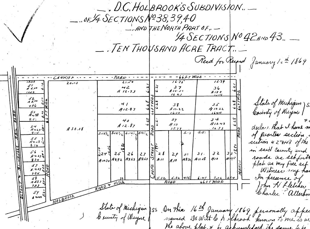
This diagonal line was created when DeWitt C. Holbrook subdivided the land he owned in Quarter Section 40 of the 10,000 Acre Tract in 1869. We'll probably never know exactly why. It wasn't a surveyor error at the time of the subdivision, because the plat appears to be correct. And for what it's worth, yes, the numbers in the old atlases are absolutely acres, and yes, much of Hamtramck was once divided into ten-acre lots.
Image source: http://www.dleg.state.mi.us/platmaps...SUBINDEX=10117Last edited by PSewick; June-15-17 at 08:28 AM. Reason: image ain't right
-
July-22-18, 06:24 PM #41
DetroitYES Member
- Join Date
- Dec 2011
- Posts
- 338
I'm the guy who noticed the crooked alley and started this [[now Hall of Fame) thread.
DeWitt C. Holbrook, who originally created the crooked line when he subdivided his property, eventually moved out west and settled in Walla Walla, Washington. I was just doing some genealogical research and found that my long-lost great-great grandfather also moved to Walla Walla, lived there at the same time as Holbrook, and both are buried in the same cemetery. In fact they were the same age. Maybe they were buddies...Last edited by Király; July-22-18 at 06:26 PM.
-
July-23-18, 06:41 AM #42
DetroitYES Member
- Join Date
- Jun 2009
- Posts
- 11,863
I remember that thread K!

 Reply With Quote
 Posting Permissions
Instagram
DetroitYES navigation
DetroitYES Management
© AtDetroit LLC 2000 - 2024 unless otherwise specified. Please notify us of uncited proprietary content.
Welcome to DetroitYES! Kindly Consider Turning Off Your Ad BlockingX
DetroitYES! is a free service that relies on revenue from ad display [regrettably] and donations. We notice that you are using an ad-blocking program that prevents us from earning revenue during your visit.
Ads are REMOVED for Members who donate to DetroitYES! [You must be logged in for ads to disappear]
Ads are REMOVED for Members who donate to DetroitYES! [You must be logged in for ads to disappear]
DONATE HERE »
And have Ads removed.
And have Ads removed.
Bookmarks