


Where was that photo taken at?
Results 1 to 9 of 9
-
November-01-13, 06:00 PM #1
 DetroitYES Member
- Join Date
- Mar 2009
- Posts
- 1,157
 Lowell the Banner of the rail cars...
-
November-01-13, 06:45 PM #2
DetroitYES Member
- Join Date
- Feb 2010
- Posts
- 3,901
I'm only guessing, but this is my guess: https://maps.google.com/?ll=42.27100...06539&t=h&z=18
-
November-01-13, 08:59 PM #3
DetroitYES Member
- Join Date
- Mar 2009
- Posts
- 2,166
-
November-01-13, 09:32 PM #4
DetroitYES Member
- Join Date
- Mar 2009
- Posts
- 1,157
Yep that one there...
-
November-01-13, 10:51 PM #5
DetroitYES
- Join Date
- Feb 2009
- Posts
- 6,802
Here ya go. Thanks to google maps one can now take a trip down Old Mount Elliott where that "Slide of Detroit" photograph came from.
http://goo.gl/maps/M81XM
-
November-01-13, 11:20 PM #6
DetroitYES
- Join Date
- Feb 2009
- Posts
- 6,802
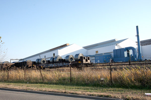
48307, here is a picture of your location. Steel roll carriers by Great Lakes Steel next to Belanger Park.
-
November-02-13, 10:02 AM #7
DetroitYES Member
- Join Date
- Mar 2009
- Posts
- 1,157
Cool Thanks Lowell...
-
November-02-13, 03:46 PM #8
DetroitYES Member
- Join Date
- Feb 2010
- Posts
- 3,901
Thanks Lowell!
Mt. Elliot was my first guess because I go by it so often, but I couldn't replicate the angle from Google maps.
-
November-02-13, 05:05 PM #9
DetroitYES Member
- Join Date
- Apr 2009
- Posts
- 1,531
I wondered where that rail yard was too. I'm thinking of modeling a section of Detoit area railroad in HO. Any suggestions? Heres a link to a HO layout of a downtown Miami industrial spur. This is what I'm going for.
http://mrr.trains.com/videos/user-vi...ing-the-canyon

 Reply With Quote
 Posting Permissions
Instagram
DetroitYES navigation
DetroitYES Management
© AtDetroit LLC 2000 - 2024 unless otherwise specified. Please notify us of uncited proprietary content.
Welcome to DetroitYES! Kindly Consider Turning Off Your Ad BlockingX
DetroitYES! is a free service that relies on revenue from ad display [regrettably] and donations. We notice that you are using an ad-blocking program that prevents us from earning revenue during your visit.
Ads are REMOVED for Members who donate to DetroitYES! [You must be logged in for ads to disappear]
Ads are REMOVED for Members who donate to DetroitYES! [You must be logged in for ads to disappear]
DONATE HERE »
And have Ads removed.
And have Ads removed.
Bookmarks