


When was the last year there were real farms in Detroit? I know out in Southgate there was a real farm about 10 years ago or so that backed up to I-75, might still be there except the land has been build on.
Results 1 to 25 of 28
Thread: Detroit Farms
-
November-04-10, 10:20 AM #1littlebuddy Guest
 Detroit Farms
-
November-04-10, 10:53 AM #2
 DetroitYES Member
- Join Date
- Apr 2009
- Posts
- 5,875
Since Detroit is an international metropolis as the intention of this board points out, there are still lots of farms operating in it. Do you mean the City itself? The City of Detroit has a 4 H club that operates a farm on McClellen. Detroit Publuc Schools operates a farm at Catherine Ferguson. The Capucian Monks Operate a farm near Mount Elliot and Lafayette within the City Limits.
-
November-04-10, 05:07 PM #3littlebuddy Guest
I don't mean an acre or so, but 80 acres, dairy, cows, etc.
-
November-04-10, 06:56 PM #4
DetroitYES
- Join Date
- Feb 2009
- Posts
- 6,778
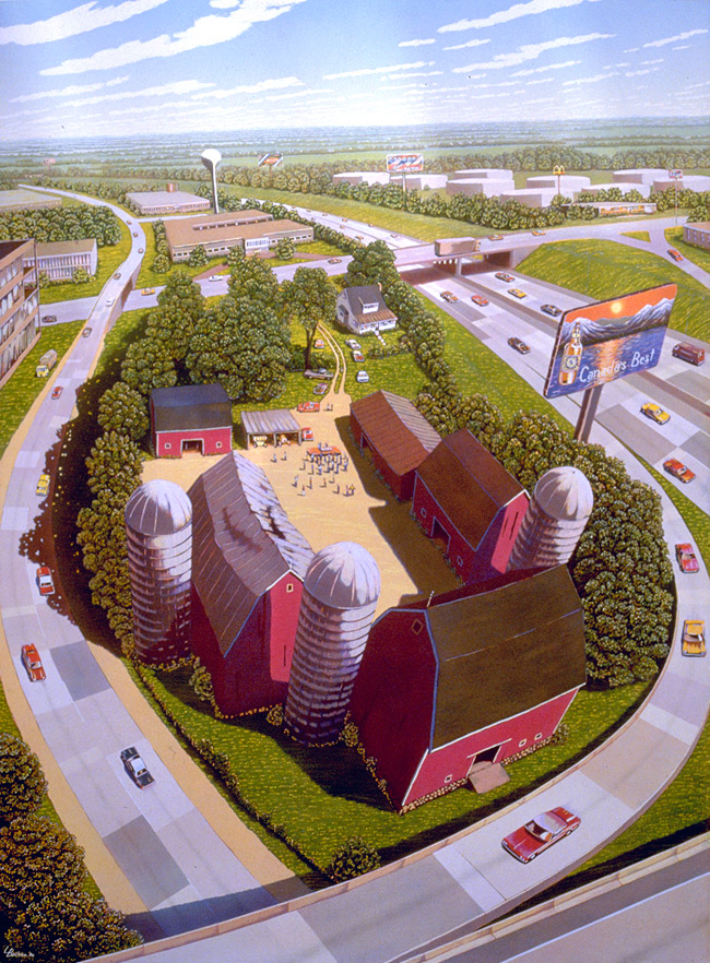
I believe I recall that farm, certainly one similar. I was struck by how out of place and doomed it seemed abutted to the expressway. I made several sketches of it. Those were later incorporated into this 4' x5' allegorical painting called "Auction" in the mid 80's, part of a suite called Michigan at the End of the Industrial Age. The expressways become a vise squeezing out the farm. This was a period of large scale collapse of small "family" farms. The price of farmland had soared, farmers borrowed heavily on the increased valuations, then the prices collapsed and the foreclosures came. Sound familiar?
-
November-04-10, 10:04 PM #5
DetroitYES Member
- Join Date
- Mar 2009
- Posts
- 2,200
Just guessing here but I would say the 1920s. That's when the land speculators got ahold of acreage out in "the sticks" of Redford Township and had those areas annexed into the city for new subdivisions. Same with portions of Gratiot Township. This maps been posted here a few times illustrating the timeframe for the expansion of Detroit's city limits.
http://farm5.static.flickr.com/4024/...86f22cd8_b.jpg
-
November-04-10, 11:28 PM #6
DetroitYES Member
- Join Date
- Apr 2009
- Posts
- 1,211
I am probably wrong but what about the soybean fields where the Wal Mart, Borders, Home Depot and others are located at Ford and the Southfield Freeway. Is that Dearborn or Detroit?
-
November-04-10, 11:52 PM #7
DetroitYES Member
- Join Date
- Sep 2010
- Posts
- 49
That was the Schafer farm in Southgate...Mr Schafer donated lots of land to the city, and they named one of the high schools after him
-
November-05-10, 12:15 AM #8
DetroitYES Member
- Join Date
- Mar 2009
- Posts
- 45
Great question!
I assume you mean as Detroit was expanding in the first half of the 20th century and not taking into account the recent small farming that is occurring. I would have to guess perhaps as a late as 1950 or so maybe. In the 1949 aerials there is a lot of open land west of Evergreen and even some decent tracts west of Southfield Road. It also seems that the land speculation of the 1920s put the cities street grid over countless acres of land west of Livernois as many old aerials show nothing but open flat land that looks like farmland with dirt roads and no houses stretching off into the horizon.
-
November-05-10, 12:26 AM #9LDoolan Guest
That would've been land owned by Henry Ford. The property lines for Fair Lane Estate were Michigan Ave to the South, Southfield to the East, Ford Road to the North. He also owned numerous other pockets of land around this area.
 Originally Posted by fareastsider

To the north of Ford's estate was the Dahlinger Estate which was mostly farmland & horse tracks until it was subdivided into River Oaks subdivision in the late 1950s. Here's a thread on that if you're interested.
http://www.detroityes.com/mb/showthr...ight=dahlinger
-
November-05-10, 05:05 AM #10
DetroitYES Member
- Join Date
- May 2009
- Posts
- 250
Soybean and corn fields, located in Dearborn, from the Detroit border at Tireman to Ford Rd. Originally Posted by reddog289
Perhaps Henry Ford II had a sentimental attachment to the farm heritage?
Not long after he passed, the land was developed. The corn maze there was fun about this time of the year.
Obviously that farm land was more viable for office and retail.
It was strange that with all that open land by Ford HQ, Ford leased space at Ren Cen .
The farmer was from Flat Rock area, it was interesting whenever they transported the tractors, etc up Telegraph heading to Dearborn.
Ford probably actually paid the farmer to plant and harvest crops there, it could not have been profitable to move equipment and the harvest from there to 'market'[[grain elevators, etc)
-
November-05-10, 08:38 AM #11woodwardboy Guest
Take a look at these aerial maps. It appears some of northern Detroit was still farm land in the early 1950s.
http://www.clas.wayne.edu/photos/par.../de-31-139.pdf
http://www.clas.wayne.edu/photos/par.../de-31-138.pdf
http://www.clas.wayne.edu/photos/ap_index.htm
-
November-05-10, 09:05 AM #12
DetroitYES Member
- Join Date
- Mar 2009
- Posts
- 1,370
Despite what the index shows, those aerial images are of the Huron River as it flows through Rockwood, MI. Here's a link to Google Maps showing how it looks today. Originally Posted by woodwardboy
-
November-05-10, 09:32 AM #13
DetroitYES Member
- Join Date
- Mar 2009
- Posts
- 2,160
There are a handful of those photos, especially from 1952, that are incorrectly indexed.
-
November-06-10, 03:29 AM #14
DetroitYES Member
- Join Date
- Apr 2009
- Posts
- 4,513
When my father attended Denby during WWII most of the land north of the school was still rural. One of Dad's best friends there lived within walking distance of the school in an old farmhouse north of Morang. By that time some of their land had already been sold off, but they still ran a small truck farm operation. After the war they sold the rest of the land off for housing. His family kept the original house though, and my Dad's friend lived there until he died in the late '90s.
My Dad tells me that there were still some small farms in the area on the both sides of 8 Mile until just a year or two before Eastland opened.
-
November-06-10, 07:08 AM #15
DetroitYES Member
- Join Date
- May 2010
- Posts
- 342
Someone in another thread said there was until the early sixties the remnant of the farm with a barn and horse that occupied the land Eastland was built on. You can see it in the upper left corner of this aerial photo from 1962.

A 1915 map shows most of the land in the northeast corner of Detroit where I live was still farmland parcels. A 1936 map shows most of the land subdivided as it is now, while the majority of Harper Woods was still farmland.
The subdivision I live in, bounded by Hayes, Brock, 7 Mile and State Fair, was one of the parcels John Salter Jr. farmed. The house his father built in the 1870's stood on 7 Mile until the early 1990's. When it was razed they found it had been built on the site of an older log cabin. The old woman who lived there sometimes hung out at the Brock party store shooting the breeze with the proprietors. There's a farmhouse still standing on Gratiot that I believe may have been built by Xavier Bringard during the civil war or the decade following. There are a couple of others still surviving on more residential streets.
Last edited by Brock7; November-06-10 at 07:31 AM.
-
November-06-10, 12:57 PM #16littlebuddy Guest
I grew up about a block from the farmland between Southfield Freeway and Michigan Ave in Dearborn. There were a couple of woodlots where they have those two white office towers right off of Southfield Freeway along with the farmland. Is the farm buildings still around in Southgate?
-
November-06-10, 08:15 PM #17
DetroitYES Member
- Join Date
- Apr 2009
- Posts
- 1,531
I think there is one barn still standing at the Southgate part of Schafers farm. It should be visible from southbound 75 looking to the west just before the Northline Road exit. A house is still there as well and I believe this is the original house. That farm used to be huge. One of my earliest childhood memories is waiting in the family car as they brought the cows across the road at Allen Rd and Pelham.
-
November-07-10, 07:22 AM #18
DetroitYES Member
- Join Date
- Apr 2009
- Posts
- 210
Here is some land in the city that we could turn into a farm

-
November-07-10, 07:34 AM #19
DetroitYES Member
- Join Date
- Mar 2009
- Posts
- 1,470
It had to have been in the far NE corner near Eastland Mall, which was also a farm at one time. I have a picture somewhere that has a relative standing the corner of Boulder and maybe Collingham looking east and it is nothing but open field.
-
November-07-11, 02:48 PM #20
DetroitYES Member
- Join Date
- May 2010
- Posts
- 122
Yup - there was a farm house on what is now the current [[now former) Notre Dame High School. I remember the student handbook when I attended there in the late 70's with a history of the school and how the Marist Fathers took applications for admission from the farmhouse on the property before the school was built. Originally Posted by Patrick
-
November-07-11, 05:02 PM #21
DetroitYES Member
- Join Date
- Jul 2009
- Posts
- 4,859
There is/was a house on the east side Greenfield between Midland and Pilgrim that I was told was a farmhouse for quite a number of acres. I don't know the timeframe though. Must have been 1930s or earlier.
-
November-08-11, 03:33 AM #22
DetroitYES Member
- Join Date
- Sep 2011
- Posts
- 875
The city's last annexation occured in 1926. I'd bet most everything within the city had been developed by the end of the 30's.
-
November-08-11, 06:48 AM #23
DetroitYES Member
- Join Date
- Mar 2009
- Posts
- 1,370
Depends what you mean by "developed". Large areas of the northwest side had been platted in the late 1920s but stood empty of houses because of the Great Depression in the 1930s and war-time building materials rationing in the 1940s. They wouldn't be built out until the late 1940s and early 1950s. Originally Posted by Dexlin
Aerial photo looking northwest along the John Lodge [[under construction) from Wyoming, April 14, 1930.
Aerial photo looking west at the John Lodge and Outer Drive intersection, July 9, 1932.
-
November-08-11, 01:31 PM #24
DetroitYES Member
- Join Date
- Apr 2009
- Posts
- 4,513
Originally Posted by Mikeg
Just a slight modification. What those photos show is the early 1930s construction of the original surface-level Northwestern Highway [[aka James Couzens Parkway in Detroit). The Lodge Freeway was built along that routing in the early 1960s.
I can still remember when the freeway ended at Wyoming and you had to continue on the parkway to get out to Southfield and Northland. Northland was out in semi-rural territory when it was built. My grandfather thought they were nuts to build something like that "way out in the country." He would always talk about how surprised he was that Northland was actually successful.
If you look at the DTE aerial photos from 1952 of the area where Northland would be built [[it was constructed a couple of years later) you can see that there is very little development on the Southfield side of 8 Mile. The Detroit side still has several empty areas too, although it looks like it's filling in quickly. By the time of the next aerial survey, in 1956, those Detroit areas are all filled in, Northland is up and running, and Southfield is clearly growing by leaps and bounds.
The eastside, for whatever reason, seems to have developed more quickly. In 1949 aerials the city is pretty much already built out to 8 Mile and Kelly Rd., with just a few patches of obviously new construction going on. So all of the streets my father remembered sitting empty and overgrown out past Denby High during the depression and into WWII have been built up. But obviously working farms remained on the Haper Woods/Gratiot Township side of Kelly Rd., and up into Macomb County, until Eastland was built.
-
November-08-11, 01:43 PM #25
DetroitYES Member
- Join Date
- Jan 2010
- Posts
- 83
Ironically there are parts of Detroit that are reverting to scenes much like the ones depicted in these photos.Aerial photo looking northwest along the John Lodge [[under construction) from Wyoming, April 14, 1930.
Aerial photo looking west at the John Lodge and Outer Drive intersection, July 9, 1932.

 Reply With Quote
 Posting Permissions
Instagram
DetroitYES navigation
DetroitYES Management
© AtDetroit LLC 2000 - 2024 unless otherwise specified. Please notify us of uncited proprietary content.
Welcome to DetroitYES! Kindly Consider Turning Off Your Ad BlockingX
DetroitYES! is a free service that relies on revenue from ad display [regrettably] and donations. We notice that you are using an ad-blocking program that prevents us from earning revenue during your visit.
Ads are REMOVED for Members who donate to DetroitYES! [You must be logged in for ads to disappear]
Ads are REMOVED for Members who donate to DetroitYES! [You must be logged in for ads to disappear]
DONATE HERE »
And have Ads removed.
And have Ads removed.
Bookmarks