


I have had some free time the past couple of weeks because I've finished classes but have yet to start work, so I decided to spend some time mapping Detroit's streetcar lines on google maps. Anyways, I thought I'd post it here because it seems like a lot of you guys are big transit enthusiast.
http://maps.google.com/maps/ms?hl=en...,0.617294&z=11
The map has all twenty major lines from the start of WWII. However, it is not perfect because its hard to tell exactly where the private right-of-ways are located.
Results 1 to 25 of 48
Thread: Detroit Street Railways Map
-
June-06-10, 10:40 AM #1
 DetroitYES Member
- Join Date
- Jul 2009
- Posts
- 11
 Detroit Street Railways Map
-
June-06-10, 12:04 PM #2
DetroitYES Member
- Join Date
- Mar 2009
- Posts
- 47
You are doing a nice job!
-
June-06-10, 01:36 PM #3
DetroitYES Member
- Join Date
- Mar 2009
- Posts
- 222
I agree with Karl. I've seen maps of the old streetcar system online, but all of the ones I've seen were black and white without street names, and you can't zoom in and scroll around easily like yours. Even if minor mistakes existed on yours, it's really well done in my opinion.
-
June-06-10, 05:12 PM #4Bearinabox Guest
Thanks for posting!
-
June-07-10, 07:36 AM #5
DetroitYES Member
- Join Date
- Mar 2009
- Posts
- 1,157
So complrehensive......WTH were they thinkin?
-
June-07-10, 09:33 AM #6
DetroitYES Member
- Join Date
- Apr 2009
- Posts
- 115
Eric, just got finished glancing at your work. What I've seen so far looks good!
One area you might what to look at is the east end of the Oakman line. It actually jogged about one block south along Hamilton and then east along a Private-Right-Of-Way which would be in the vicinity [[to the immediate north) of what is now Manchester Parkway. Back then Manchester, between Woodward and Hamilton, served more as a P-R-O-W along the south end of the DSR Highland Park properties. The line's east-end terminus looped just west of Woodward at the Woodward Carhouse. Overall, a great job!
BTWâI was also noticing how you correctly ended the north end of the Trumbull line at Fenkell and Birwood [[just west of Wyoming). I was just over there a few days ago and was showing a friend, who stays just down the street from there, how the "Wye" turn rails at Birwood are now starting to come through the pavement.
-
June-07-10, 11:57 AM #7
DetroitYES Member
- Join Date
- Mar 2009
- Posts
- 778
On a related note I was at the air races over the weekend and noticed along the riverwalk on Atwater there was an old railway "intersection" laying there. Work crews must have unearthed it while redoing the street over there.
-
June-07-10, 07:43 PM #8
DetroitYES Member
- Join Date
- Jul 2009
- Posts
- 11
Thanks! I'm glad you guys enjoyed it.
bc_n_dtown, thanks for your help with the Oakman line. For some reason I always thought the Woodward Carhouse was on the east side of Woodward.
-
June-07-10, 08:10 PM #9
DetroitYES Member
- Join Date
- Jan 2010
- Posts
- 101
One Shot, that was actually railroad tracks that used to suppy the many factories/industrial area that was down there once. They used to load/unload railcars in the street, in front of the factories.
-
June-07-10, 09:38 PM #10
DetroitYES Member
- Join Date
- Jan 2010
- Posts
- 90
I notice each line closed on different days. Was ridership waning as they decided to close lines? Does anyone know how working class folk who relied on the trains reacted to the closings?
-
June-08-10, 05:30 AM #11
DetroitYES Member
- Join Date
- Jan 2010
- Posts
- 4,867
As lines closed, they were converted to bus routes and the streets paved over. The streetcar lines lasted the longest on the wider streets with room for the tracks and the safety island in the streets along with several traffic lanes [[Woodward, Grand River, Gratiot). In many cases lines were closed when the requirements and expenditures to tear up the street and renovate the fifty or sixty year old track bed became necessary. Originally Posted by donpablo

.
-
June-08-10, 07:41 AM #12
DetroitYES Member
- Join Date
- Apr 2009
- Posts
- 115
Nope, the DSR properties were west of Woodward and stretched from Woodward to Third. The Ford Highland Park plant complex was across the street on the east side of Woodward. Originally Posted by Eric
-
June-21-10, 03:33 PM #13
DetroitYES Member
- Join Date
- May 2010
- Posts
- 1
If you remember, the Woodward Carhouse closed in October 1955 and was moved temporarily to the adjacent Highland Park Terminal. This was until April 1956, when all DSR rail operations were discontinued. Perhaps that was the cause of your confusion. Originally Posted by Eric
-
June-21-10, 04:20 PM #14
DetroitYES Member
- Join Date
- Dec 2009
- Posts
- 35
Wow. Makes it look like a functioning city.
Didn't the Woodward line go up to Pontiac? Which one went to Flint?
-
June-21-10, 05:34 PM #15
DetroitYES Member
- Join Date
- Mar 2009
- Posts
- 222
Indeed, Mogo. Perhaps an extensive street railway system will exist in Detroit again someday.... someday. Anyway, unless I'm mistaken, you're probably thinking of the interurbans. Originally Posted by mogo
-
June-21-10, 06:51 PM #16
DetroitYES Member
- Join Date
- Jan 2010
- Posts
- 4,867
The DSR never went to Pontiac or Flint. Originally Posted by mogo
The DUR interurbans did using the DSR lines from downtown. The Woodward line went straight out to Pontiac. The Flint line branched off the Pontiac line in Royal oak and went north through Rochester and Oxford to Flint. There was another branch from Rochester thru Romeo and Imlay City to Almont.
The Gratiot line ran out to New Baltimore, Marine City and Port Huron.
The Michigan Ave line ran out to Ann Arbor and Jackson.
The Fort Street line ran down to Monroe and Toledo.
The Grand River Line ran to Farmington and Northville
There was a line from Farmington to Orchard Lake to Pontiac.
There was a line from Wayne to Farmington.
Through a combination of hostility from government bodies, the press, and the public and from automobile competition, they all went bankrupt and were abandoned.
-
June-21-10, 08:53 PM #17
DetroitYES Member
- Join Date
- Apr 2009
- Posts
- 385
Here are a couple of photos of DSR streetcars that are being stored out at Selftridge ANG base.
http://img.photobucket.com/albums/v2...123081543a.jpg
http://img.photobucket.com/albums/v2...123081542a.jpg
-
June-21-10, 09:05 PM #18
DetroitYES Member
- Join Date
- Mar 2009
- Posts
- 29
Fantastic! Thanks for your work and appreciation.
-
June-22-10, 12:39 PM #19
DetroitYES Member
- Join Date
- Mar 2009
- Posts
- 1,045
That's so sad to see. What a backwards region we live in. It would be great to take the train from Monroe to Detroit.
Stromberg2
-
June-22-10, 12:41 PM #20
DetroitYES Member
- Join Date
- Apr 2009
- Posts
- 830
Of the photos Searay posted, only the first is a true DSR streetcar, the only known remaining PCC of the fleet from the late 40s-mid 50s, it is stored at MTM on Selfridge. The other car photographed there is a former TTC PCC car from Toronto. Toronto at one time had the largest PCC fleet in the world, and many were sent to museums and tourist lines when they were retired. They run on a funny gauge of track though, so unless it has different wheelsets added, it can't run on standard gauge track.
The Hall of Fame DSR thread is here for those who've not read it: http://atdetroit.net/forum/messages/...tml?1134428567
And from it, here is a summary of the DSR cars which still remain:
Peter Witt #3876, painted in the later attractive Maroon and Creme DSR scheme. It is at the Ohio Railway Museum, Worthington OH. [[This car is in poor shape internally and is listed for sale by the OHRY Museum)
http://www.ohiorailwaymuseum.org/museum/images/detroitcar.jpg [[Photo during better times there)
Peter Witt #3865, painted in the earlier DSR creme and green colors. It went to the Henry Ford Museum after retirement and underwent a partial renovation before being stored out of sight. The exterior restoration was completed when it was sold to the Illinois Rail Museum in Union, IL in 1998, where it is on display.
http://www.irm.org/pictures/600/3865dsr01.jpg
PCC #268, painted in the attractive PCC version of the Maroon and creme. This is the only surviving PCC from the Detroit fleet, which once numbered 189 President's Conference Committee cars. It went with the rest of the Detroit PCC fleet into service in Mexico City, and was returned to Michigan in the 1990s. It is at the Michigan Transit Museum at Selfridge ANG base in Mt. Clemens.
http://lyttonspccs.homestead.com/263.html
-
June-22-10, 03:42 PM #21
DetroitYES Member
- Join Date
- Jan 2010
- Posts
- 4,867
DSR abandoned streetcar service as follows:
1923 East Fort-East Congress
1925 Dearborn Ave
1928 West Davidson [[east of Linwood)
1929 Conant
1931 Brush
1931 Clay
1932 Harper-Center Line
1933 Scotten
1937 Myrtle
1938 Depot
1938 Van Dyke
1938 Moran-Palmer
1938 West Jefferson
1939 East Lafayette
1942 Baker-Highland Park
1945 Oakman
1946 Michigan-Through
1946 Mack-Warren
1947 Hamilton
1947 Grand River
1947 Royal Oak [[extension of Woodward)
1947 Crosstown
1947 Harper
1948 Fourteenth
1948 Woodmere
1948 Grand Belt
1949 Charlevoix
1949 Baker-Van Dyke
1949 Fort
1949 Kercheval
1949 Woodward-Boat Pier
1951 Clairmount
1951 Mack
1951 Oakland
1951 Trumbull
1951 Mt Elliot
1952 Baker
1954 East Jefferson
1955 Michigan
1956 Gratiot
1956 Woodward
Sic Transit Gloria
-
July-19-10, 10:32 AM #22
DetroitYES Member
- Join Date
- Jul 2010
- Posts
- 1
Eric, I found into some old resurfacing plans for Junction [[cedar planks were an option) There was one set rail tracks centered in Junction north of Buchanan. At Devereaux, tracks split north on Junction and west on Deveraux. Did not see any information about the likely rail connection to Buchanan, or the rails extending any further south of that intersection. Too bad my father passed away last year -- he grew up in that neighborhood and would have had first hand recollection of the rail routes.
-
July-19-10, 10:47 AM #23
DetroitYES Member
- Join Date
- Mar 2009
- Posts
- 5,457
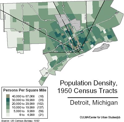
Pretty eerie how much that streetcar map correlates to what were the most densely populated neighborhoods in Detroit... which are now the least densely populated neighborhoods in Detroit...

-
July-20-10, 10:49 PM #24
DetroitYES Member
- Join Date
- Mar 2009
- Posts
- 1,090
Iheartthed you hit the nail on the head.
-
July-21-10, 12:04 AM #25
DetroitYES Member
- Join Date
- Apr 2009
- Posts
- 1,386
Actually there were two versions of the Gratiot Interurban, if you'd like to call it that, since neither ran all the way along Gratiot to Port Huron. The original line ran along Gratiot then followed roughly 23 Mile Road, M-29 and BL 94 to Port Huron. That was a very long trip, so a new line was developed that cut off part of the M-29 segment [[the new route bypassed Algonac and the St. Clair Flats). The new line was referred to as the Short Cut, and the route partly survives in that there is an east-west road in southern St. Clair County called Short Cut Road, which follows the route, and you can actually see a couple of the old interurban bridges over drains and creeks if you know where to look. Originally Posted by Hermod
By the way, the map is a wonderful resource. We need to find a way to make this broadly available to local and national street railway historians. [[And urban planners.)

 Reply With Quote
 Posting Permissions
Instagram
DetroitYES navigation
DetroitYES Management
© AtDetroit LLC 2000 - 2024 unless otherwise specified. Please notify us of uncited proprietary content.
Welcome to DetroitYES! Kindly Consider Turning Off Your Ad BlockingX
DetroitYES! is a free service that relies on revenue from ad display [regrettably] and donations. We notice that you are using an ad-blocking program that prevents us from earning revenue during your visit.
Ads are REMOVED for Members who donate to DetroitYES! [You must be logged in for ads to disappear]
Ads are REMOVED for Members who donate to DetroitYES! [You must be logged in for ads to disappear]
DONATE HERE »
And have Ads removed.
And have Ads removed.
Bookmarks