


What were the original boundaries of the city first incorporated in 1806 and then again in 1815 after the local government had went defunct? I found these slides:
http://www.drawingdetroit.com/detroi...ion-1806-1926/
The 1806 boundaries I can guess Cass to the west and Adams to the north, but I'm unsure of the eastern boundary, maybe John R.
And then during the final incorporation in 1815 the western border remains the same, but the northern border is now in Midtown and the eastern border a few blocks east.
Anyone find any maps showing the streets or property lines for these two incorporations or even just a description stating the original incorporated boundaries?
Results 1 to 11 of 11
Thread: Original City Limits
-
June-12-21, 01:29 AM #1
 DetroitYES Member
- Join Date
- Sep 2011
- Posts
- 875
 Original City Limits
-
June-12-21, 06:49 AM #2
DetroitYES Member
- Join Date
- Mar 2009
- Posts
- 6,543
By 1926 The Michigan State Legislature passed a law to prevent any city to annex townships that will be incorporated into village or be chartered.
Once an area is being incorporated or chartered, the community government must have their own police, fire dept. and water commission. If somehow they cut one of those services. They will lose incorporation or chartership. Making a neighboring city to annex that area by vote. [[ that's whoever is living that block.)
That is main reason the what's left of Redford Township become a charter TWP.
Also in 1948 The Charter Township Act. came in. This is make Michigan Lawmakers establish a State Boundary Commission to show people in that township how a township government be chartered.
In 1978 The SBC Township law has been changed so in case developers in that township or village can petition to have their lands being annexed to another city or have the people in their sub-division vote to join another city.Last edited by Danny; June-12-21 at 06:54 AM.
-
June-15-21, 03:21 AM #3
DetroitYES Member
- Join Date
- Apr 2009
- Posts
- 4,513
The 1815 borders went from Cass to Alexandrine to Beaubien.
-
June-15-21, 07:10 AM #4
DetroitYES Member
- Join Date
- Mar 2009
- Posts
- 5,839
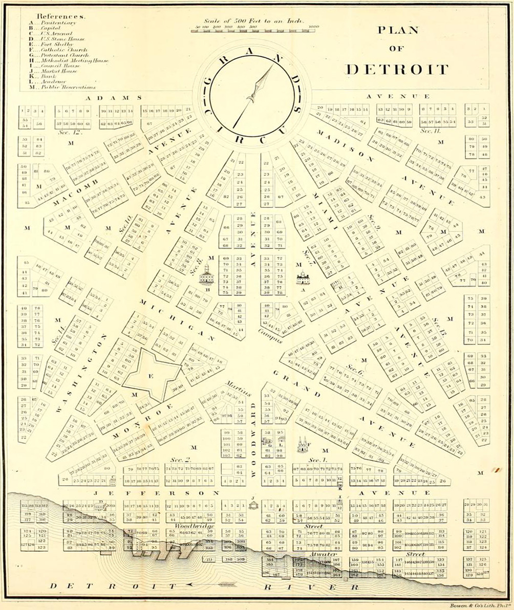
Does this map of the Woodward Plan help with 1806?
-
June-15-21, 06:48 PM #5
DetroitYES Member
- Join Date
- Mar 2009
- Posts
- 6,543
Judge August Woodward want Downtown Detroit to look like a Washington D.C. Clone. But the Feds say NO! So Woodward redesign Downtown Detroit to what we see today.
-
June-15-21, 11:08 PM #6
DetroitYES Member
- Join Date
- Mar 2010
- Posts
- 186
some where there's an old thread with a colorized map of the annexation boundaries 1806-1926.
Maybe Lowell recalls?
-
June-15-21, 11:18 PM #7
DetroitYES Member
- Join Date
- Sep 2011
- Posts
- 875
Thanks! Originally Posted by EastsideAl

That'd mean the western boundary for 1806 incorporation would have still been Cass. Looking more closely, I'd bet Adams was the original northern boundary, and Randolph the eastern one [[instead of John R.). But that's just a guess.
BTW, the map being talked about doesn't really show detail close to downtown, so like all the rest you've had to guess.
-
June-16-21, 06:51 AM #8
DetroitYES Member
- Join Date
- Mar 2009
- Posts
- 2,160
That map can be found at several sites online. Just search for annexation of detroit. He's a close up of the area being talked about: Originally Posted by wilderness
-
June-16-21, 09:38 AM #9
DetroitYES Member
- Join Date
- Dec 2018
- Posts
- 158
Not quite...ever spent any meaningful amount of time in DC? There was inspiration, in terms of the wide diagonal avenues. But DC is a grid system cross-cut by diagonal avenues and public squares. The Woodward Plan was almost all diagonal roads that would create a scaling, almost fractal, series of triangles to maximize the amount of street-facing land. Originally Posted by Danny
Also, the feds largely approved his plan. It was local leaders and the governor who grew to disdain it, and a lot of the original records were lost during the War of 1812, causing further confusion about the plan and leading to its ultimate abandoment.
-
June-16-21, 05:46 PM #10
DetroitYES Member
- Join Date
- Mar 2009
- Posts
- 6,543
Only the Grand Circus wagon wheel plan. not the rest of the street plan.
What I really like to see is Detroit amalgamate all the surrounding suburbs. But it's not going to happen due to Charter Township Laws and city and village boundary laws. Also add in race in politics and huge taxation.
In Chicago, Ill. their annexation was superfast thanks to Illinois Legislation.Last edited by Danny; June-16-21 at 05:51 PM.
-
June-18-21, 12:18 AM #11
DetroitYES Member
- Join Date
- Sep 2011
- Posts
- 875
Okay, so this map DID in fact show street names were applicable. Thanks, again. Originally Posted by MikeM

 Reply With Quote
 Posting Permissions
Instagram
DetroitYES navigation
DetroitYES Management
© AtDetroit LLC 2000 - 2024 unless otherwise specified. Please notify us of uncited proprietary content.
Welcome to DetroitYES! Kindly Consider Turning Off Your Ad BlockingX
DetroitYES! is a free service that relies on revenue from ad display [regrettably] and donations. We notice that you are using an ad-blocking program that prevents us from earning revenue during your visit.
Ads are REMOVED for Members who donate to DetroitYES! [You must be logged in for ads to disappear]
Ads are REMOVED for Members who donate to DetroitYES! [You must be logged in for ads to disappear]
DONATE HERE »
And have Ads removed.
And have Ads removed.
Bookmarks