


Where can I find pictures of the east side of Woodward prior to its destruction and redevelopment? I remember walking by it when i was walked around downtown one last time before I joined the Army in 1993 but I cannot for the life of me remember what any of it looked like! In particular the area east of Woodward, south of 75 and north of GCP.
Results 1 to 25 of 37
-
December-24-20, 03:02 AM #1
 DetroitYES Member
- Join Date
- Mar 2009
- Posts
- 1,157
 Pictures of east side of Woodward prior to its redevelopment?
-
December-24-20, 03:22 AM #2
 DetroitYES Member
- Join Date
- Mar 2009
- Posts
- 9,402
Detroit Stylin,
I worked downtown for 6 months in 1977, and used to park my car in the sea of parking lots located across from the Fox. From my memory, I only remember 3 buildings between Elizabeth and Montcalm, Woodward and Witherell. Those were the Elwood Bar on Woodard & E. Elizabeth, the Germ/Century Theatres on E. Montcalm & Witherell [[both relocated farther east next to Ford Field), and the 17 story Wolverine Hotel, demolished for the Stadia district.
IIRC, all the rest of that area between Central Methodist and St. John's churches was already parking by 1977.
-
December-24-20, 07:44 PM #3
DetroitYES Member
- Join Date
- Apr 2009
- Posts
- 4,513
And Jolly Jim's Coney Island, corner of Woodward and E. Columbia.

-
December-24-20, 07:49 PM #4
DetroitYES Member
- Join Date
- Apr 2009
- Posts
- 4,513
Here is a picture of the Elwood Bar in its original Woodward & E. Elizabeth location. Wolverine Hotel on the right and YWCA in the background, both on Witherell.

Last edited by EastsideAl; December-24-20 at 07:53 PM.
-
December-24-20, 08:01 PM #5
DetroitYES Member
- Join Date
- Mar 2009
- Posts
- 1,157
 Originally Posted by EastsideAl

wow i know ive been down there in 1993 before I joined the Army but i can NOT for the life remember seeing that side of Woodward like this.
-
December-24-20, 08:06 PM #6
DetroitYES Member
- Join Date
- Apr 2009
- Posts
- 4,513
The other buildings on that strip, both of which are still there, were Central Methodist at Adams, just north of GCP, and St. John's Episcopal at I-75/Fisher Fwy [[or E. Vernor, depending how old you are). Gem Theater was just around the corner on E. Columbia. Other than these buildings, like Gistok said, there was nothing on that stretch but parking lots by the '70s.
-
December-24-20, 08:53 PM #7
DetroitYES Member
- Join Date
- Sep 2011
- Posts
- 875
From Lowell years ago:
https://www.detroityes.com/downtown/22ywca.php
And from an old post on this area:
https://www.detroityes.com/mb/showth...646#post291646
More:


Last edited by Dexlin; December-24-20 at 09:02 PM.
-
December-26-20, 11:52 PM #8
DetroitYES Member
- Join Date
- Mar 2009
- Posts
- 1,157
But there are absolutely no images available of the clubs that made up Paradise Valley. Seems to be the only one I have been able to find where ones of the 606 Horse Shoe Lounge
-
December-27-20, 05:24 AM #9
DetroitYES Member
- Join Date
- Apr 2009
- Posts
- 4,513
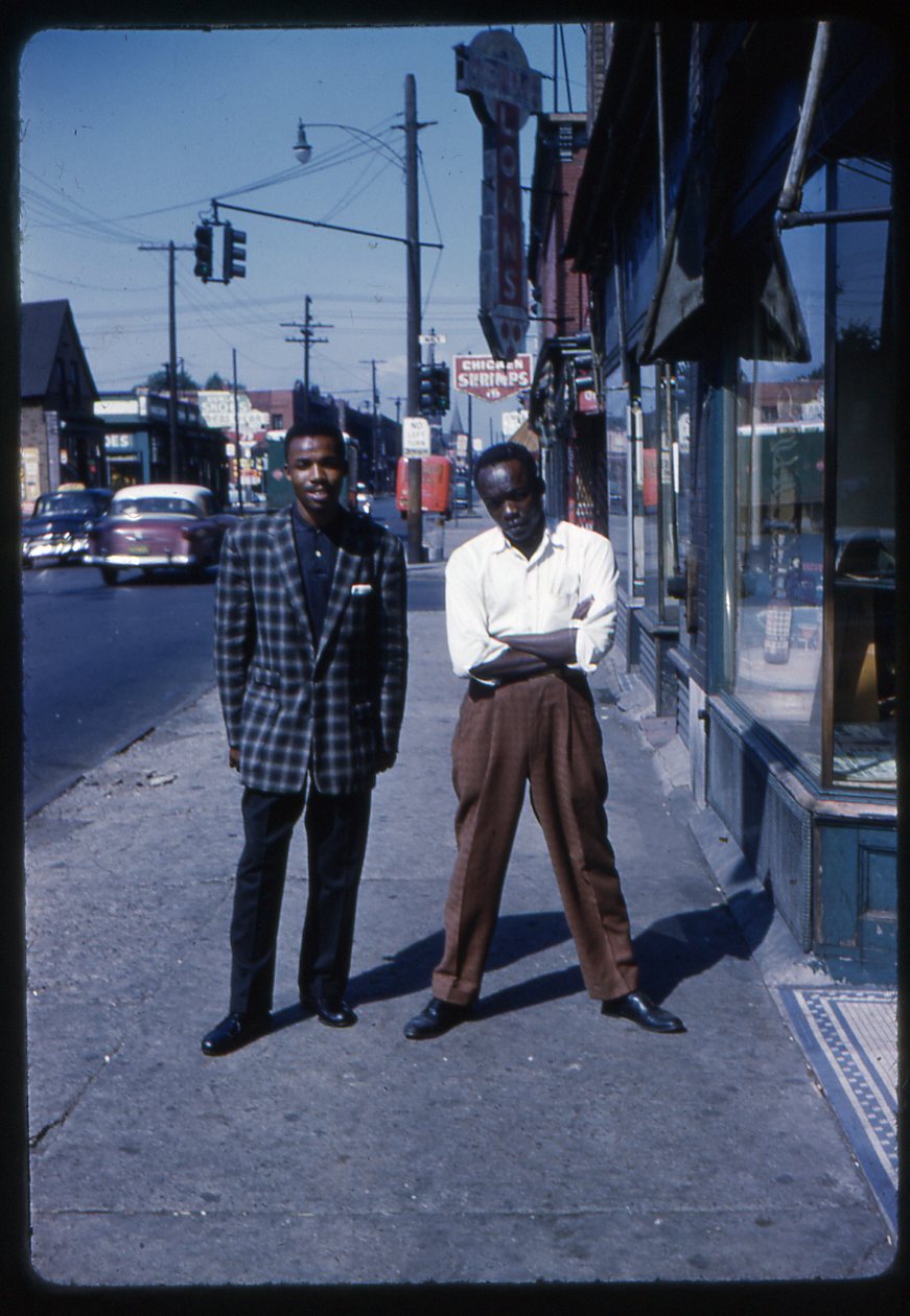
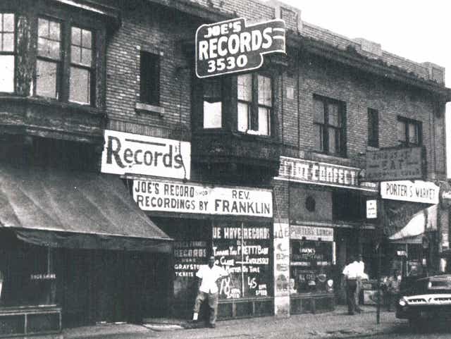
This is true. There are almost no such images available. In fact, there are not that many images around of Hastings St. during its heyday at all. The shots that were taken by Jacques Demetre in front of Joe Von Battle's record shop on Hastings of a few of the artists who recorded there are some of the few public documents of how the street appeared, just before it was cleared away for the freeway. Originally Posted by Detroit Stylin
Little Sonny and John Lee Hooker, in front of 3530 Hastings near Mack [[From the blog of Marsha Music, who used to post here, and who is Joe Von Battle's daughter):
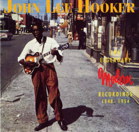
Another shot from the same photo session, that has been used as an album cover:
Joe's Record Store:
Last edited by EastsideAl; December-27-20 at 06:00 AM.
-
December-27-20, 05:58 AM #10
DetroitYES Member
- Join Date
- Apr 2009
- Posts
- 4,513
And this marvelous shot of Hastings St. circa 1942. Not sure what the cross-streets are here.

-
December-27-20, 09:07 AM #11
DetroitYES Member
- Join Date
- Mar 2009
- Posts
- 2,160
This is actually St Antoine at Beacon Street, looking north. Originally Posted by EastsideAl
-
December-27-20, 10:14 AM #12
DetroitYES Member
- Join Date
- Aug 2010
- Posts
- 622
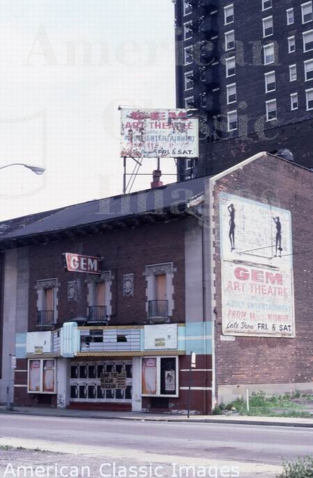
In 1967 the theater was renamed the Gem and operated as an adult movie house, that closed in 1978. This reminds me of a funny story from 1991: Originally Posted by EastsideAl
Pee-wee Herman, a.k.a. Paul Reubens, was arrested for “touching himself” in a darkened adult movie theater. Maybe Pee-Wee left some of his “DNA” behind at the GEM theater during one of trips to Detroit.
-
December-28-20, 10:03 AM #13
DetroitYES Member
- Join Date
- Mar 2009
- Posts
- 5,839
Isn't this the Gem that was put on roller's and moved down the street to become the Gem and Century, a live theater on Madison?
Originally Posted by CassTechGrad
-
December-28-20, 01:53 PM #14
DetroitYES Member
- Join Date
- Mar 2009
- Posts
- 621
[QUOTE=Dexlin;604956]From Lowell years ago:
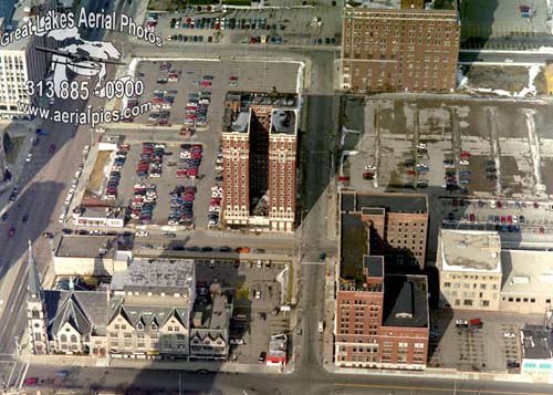
These are great, and help frame up the area for me. I had never seen the aerial images [[and obviously Lowells post) before. Thank you for sharing!
-
December-28-20, 07:34 PM #15
DetroitYES Member
- Join Date
- Sep 2011
- Posts
- 875
Hey, what was the building at the southeast corner of Montcalm and Witherell? And the building Adams was the YMCA and the one on Elizabeth was the Hotel Wolverine, correct? Looks like most of the neighborhood was gone when they decided to build Comerica Park, there.
If anyone can find old Sanborn Fire Maps of this area east of Woodward and north of Adams post 1920's or 1930's, that'd be great.
-
December-28-20, 08:07 PM #16
DetroitYES Member
- Join Date
- Mar 2009
- Posts
- 2,160
y.w.c.a. Originally Posted by dexlin
-
December-28-20, 08:09 PM #17
DetroitYES Member
- Join Date
- Mar 2009
- Posts
- 2,160
^ I have no idea why it won't let me capitalize YWCA.
-
December-28-20, 11:24 PM #18
DetroitYES Member
- Join Date
- Mar 2009
- Posts
- 1,157
Yep that's the one. Originally Posted by jcole
-
December-29-20, 12:07 AM #19
DetroitYES Member
- Join Date
- Sep 2011
- Posts
- 875
Ha, right down the street from the YMCA. I'd love to hear some old stories from that arrangement. lol Originally Posted by MikeM
Check out this photo I found on Ebay. It's looking over Grand Circu Park from atop the old YMCA in the 1950's:
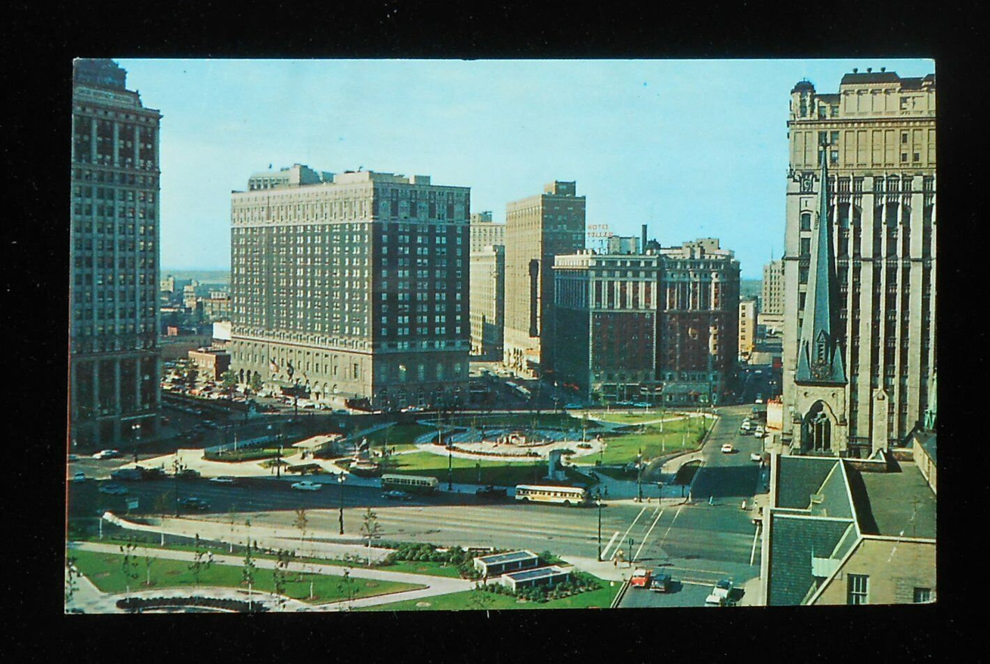
Ebay
Of course the Statler aqnd Tuller are now gone. Looks like an Olympia shell company still owns most of the Tuller lot. For some reason, the rest of the lot [[at the corner of Adams and Clifford) is owned by Miller Canfield's Troy office.
And the city and county through their stadium authority owns the two stadium lots lining Woodward.Last edited by Dexlin; December-29-20 at 12:16 AM.
-
December-29-20, 01:17 AM #20
DetroitYES Member
- Join Date
- Mar 2009
- Posts
- 9,402
Beth Duncombe... the predecessor to George Jackson, head of the DEGC [[and sister-in-law to Mayor Archer), was the person who came up with the idea of moving the Gem/Century to its' current site on city owned land along Madison Ave.
And here is an old post card of the elegant looking Wolverine Hotel. Had the Ilitches [[vis a vis the Wayne County Stadium Authority) not demo'ed it for no reason except parking... it would have made a nice 17 story apartment building with spectacular views of Comerica park and Foxtown...
-
December-29-20, 09:20 AM #21
DetroitYES Member
- Join Date
- Mar 2009
- Posts
- 4,512
I forgot GCP used to be flat. It looks so much better and more inviting than those mounds. Originally Posted by Dexlin
-
December-29-20, 09:36 AM #22
DetroitYES Member
- Join Date
- Mar 2009
- Posts
- 5,839
My husband went to DCL on E. Elizabeth back in the early 70's, 1 and 1/2 block off Woodward. Used to turn onto Elizabeth right next to the Elwood to get to school. One of my highlights was when I went to school with him one night and on the way out, he went north on John R to leave school and we got into a hooker/pimp traffic jam at the bar on the corner of Colombia and John R.
Great pics of that area here: https://www.historicdetroit.org/gall...lverine-photosLast edited by jcole; December-29-20 at 10:06 AM.
-
December-29-20, 12:15 PM #23
DetroitYES Member
- Join Date
- Mar 2009
- Posts
- 1,493
In the 90s, I worked at 640 Temple. I had discovered a nice little cafe that I grabbed lunch from a few times a week. It was called Elizabeth Street Cafe. It was on the ground floor of the Elizabeth Building. I want to say it was on the corner of Elizabeth & John R. Even if my memory isn't exact, it's safe to say it's location is now the Comerica Park outfield. I remember driving down Park when it still crossed the Fisher to Elizabeth to get to the cafe. I remember the owner having a countdown on a small chalk board to the day they had to move out. I lunched at the Elwood a few times too, but never Jolly Jims. But yes, as others have said there wasn't much else but parking lots around there in the 90s right before the stadiums were built. If you look at post #7 where Dexlin posted some links, check out the 2nd one. That whole post has many photos of the pre-stadium area.
-
December-29-20, 12:20 PM #24
DetroitYES Member
- Join Date
- Mar 2009
- Posts
- 9,402
In 1955 all of Grand Circus Park was torn up to put the underground garage into. So that "tree-less" W. GCP pic that Dexlin posted likely dates to between 1956-59. In 1959 the David Whitney Building got its' modernization [[which has mercifully been undone a few years ago), and I believe that the Michigan Mutual Building [[formerly Stroh's HQ) was modernized around the same time, since it still shows its' corner towers. Originally Posted by 401don
Here is the 1955 "big dig" of GCP...
-
December-29-20, 12:28 PM #25
DetroitYES Member
- Join Date
- Mar 2009
- Posts
- 9,402
Here is another pic of W. GCP that still shows the Shurly Hospital [[demo'ed in the 1950s) between the Kales and Fine Arts Building. This is a Metro Times pic that shows half old image/half modern image. Note: the old Stroh's HQ [[Michigan Mutual) shows the before [[left side) and after [[right side) of the building top.

 Reply With Quote
 Posting Permissions
Instagram
DetroitYES navigation
DetroitYES Management
© AtDetroit LLC 2000 - 2024 unless otherwise specified. Please notify us of uncited proprietary content.
Welcome to DetroitYES! Kindly Consider Turning Off Your Ad BlockingX
DetroitYES! is a free service that relies on revenue from ad display [regrettably] and donations. We notice that you are using an ad-blocking program that prevents us from earning revenue during your visit.
Ads are REMOVED for Members who donate to DetroitYES! [You must be logged in for ads to disappear]
Ads are REMOVED for Members who donate to DetroitYES! [You must be logged in for ads to disappear]
DONATE HERE »
And have Ads removed.
And have Ads removed.
Bookmarks