


When one inch of rain causes 90 Million gallons of combined sewage overflow to occur -- The Clinton River jumps from 8ft to 15 ft -- in under 12 hours.
That water goes to Lake St Clair and the Detroit River -- where folks are sand bagging tonight 4/29/2019 in the canals.
Ecoli and bacteria from CSO events sticks to sand, which is just ground up rocks, rough on its surface, perfect for bacteria to stick to, and stay moist.
Pick your news source - plenty exist.
Results 1 to 25 of 35
Thread: Flooding - Spring Rain
-
April-29-19, 10:36 PM #1
 DetroitYES Member
- Join Date
- Mar 2017
- Posts
- 1,639
 Flooding - Spring Rain
-
April-30-19, 05:24 AM #2
DetroitYES Member
- Join Date
- Mar 2009
- Posts
- 6,547
OH well, that will be the lesson to those developers long ago. Do not built your properties so close to the water, rivers, lakes and canals.
-
April-30-19, 09:18 AM #3
DetroitYES Member
- Join Date
- Mar 2017
- Posts
- 1,639
Flooding in Jefferson Chalmers neighborhood
https://www.clickondetroit.com/news/homeowners-fill-sandbags-to-protect-from-flooding-in-jefferson-chalmers-neighborhood
-
April-30-19, 09:23 AM #4
DetroitYES Member
- Join Date
- Mar 2009
- Posts
- 1,017
The flooding has nothing to do with the current rain. This has nothing to do with the inputs into the Clinton River.
This is a seiche.
https://oceanservice.noaa.gov/facts/seiche.html
The lakes are way higher than usual due to the winter weather in Northern Michigan. When the lakes are this high and the wind blows in from the north east., That corner of Detroit floods. When the winds are out of the due east The western shore of Lake Erie in Monroe floods.
-
April-30-19, 09:40 AM #5
DetroitYES Member
- Join Date
- Mar 2017
- Posts
- 1,639
Seiche is part of it, not all. Something made the lakes high, eh. Weather
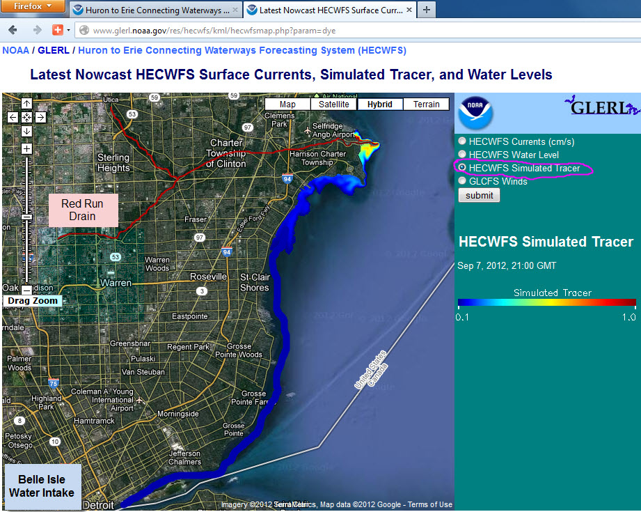
https://twitter.com/DetroitWaterDep/status/1123217978093449217
The sewage overflow hugs the coastline with the wind. Example :

Last edited by O3H; April-30-19 at 09:53 AM.
-
April-30-19, 09:55 AM #6
 DetroitYES Member
- Join Date
- Mar 2009
- Posts
- 9,407
Thanks Ndavies... some of the Great Lakes are reaching some record highs not seen in 40 years....
https://www.detroitnews.com/story/ne...ls/2831489002/
https://www.mlive.com/news/2019/04/g...gh-summer.html
https://wbckfm.com/lake-superior-water-levels/
-
April-30-19, 10:41 AM #7
DetroitYES Member
- Join Date
- Mar 2009
- Posts
- 1,355
 Originally Posted by Gistok

And exacerbating the problem is that just a few years before we were dealing with record low lakes levels. In those years many lake front property owners neglected to maintain or rebuild their seawalls and even built homes in low lying areas without them. Most of what has been built on the banks of Lake St. Clair was once nothing more than swamp. It's been drained, filled in and walled off to keep the water at bay, but fighting Mother Nature is a never ended battle.
That said, when the vast majority of Metro Detroit residents rely on the Detroit River for drinking water, controlling untreated sewage runoff into the system needs to be a top priority.
-
April-30-19, 12:26 PM #8
DetroitYES Member
- Join Date
- Mar 2017
- Posts
- 1,639
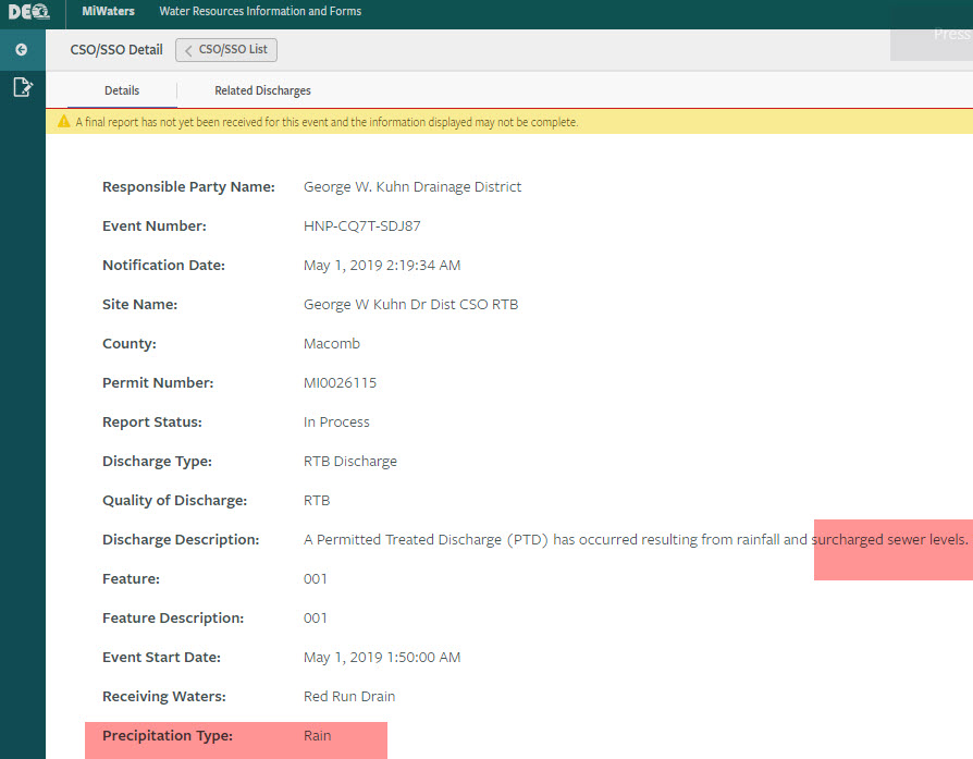
But, but, but, but, but, but ----- It is allowed ----- by law --- via Permit
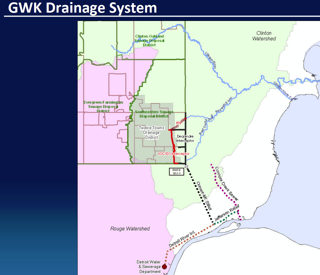
The sewage overflow underwent a ""treatment"" of some screening,
and a spritz of a bit of sodium hypochlorite as it raged in a dynamic flow , underground in the GWK Retention basin, released into Warren
via the Red Run Drain.
-
April-30-19, 01:48 PM #9
DetroitYES Member
- Join Date
- Mar 2009
- Posts
- 132
The lakes were this high in 1986. Every time I look at the radar, its raining in Michigan. I think you will see flooding in Detroit, Grosse Pointes and St Clair Shores because the lakes continue to rise until mid summer.
-
April-30-19, 04:11 PM #10
DetroitYES Member
- Join Date
- Mar 2009
- Posts
- 2,161
It's episodic. Before that, I remember the sandbagging of '73 throughout SCS, GP, Detroit. People then blamed the USCAE for manipulating the lake levels to avoid dredging expenses. Originally Posted by bibs
-
April-30-19, 05:08 PM #11
DetroitYES Member
- Join Date
- Mar 2009
- Posts
- 132
I remember those barriers wells. The home owners were told not to remove them. Guess, what! They were blocking their view of the water so they removed them. My dad told me today that water is over on Jefferson in St Clair Shoes at the Blue Goose.
-
April-30-19, 06:45 PM #12
DetroitYES Member
- Join Date
- Mar 2009
- Posts
- 9,407
Interesting... I rode my bike over to the SCS library yesterday at 11 & Jefferson, just 1/2 mile south of the Blue Goose, and not a drop of water! But then again the Blue Goose is right next to the water, and the Civic Center is over 1000 ft. from the lake.
-
April-30-19, 06:51 PM #13
DetroitYES Member
- Join Date
- Mar 2009
- Posts
- 2,195
Add Harrison Township to the mix. Friends of ours have been fighting with a neighbor to fix his seawall for a year. It is now taking the one lane road with it. Water is inches from street level.
-
April-30-19, 10:38 PM #14
DetroitYES Member
- Join Date
- Mar 2017
- Posts
- 1,639
Clinton River folks affected as well
https://www.wxyz.com/news/businesses..._6wM910IqqG_7w
-
May-01-19, 05:51 AM #15
DetroitYES Member
- Join Date
- Mar 2009
- Posts
- 6,547
Most modern suburban homes built after 1990 will have built in sump pumps. Other homes built before 1990 will not have sump pumps. It's about time to get a sump pump unless you want to deal with a moldly sweaty flooded basement.
-
May-01-19, 07:47 AM #16
DetroitYES Member
- Join Date
- Mar 2009
- Posts
- 712
In Rochester Hills, my sump pump is running about every 90 seconds. At least I hope it still is!
-
May-01-19, 08:44 AM #17
DetroitYES Member
- Join Date
- Mar 2017
- Posts
- 1,639
Clinton River measured by USGS gauges in Fraser on Garfield
now shows 16 ft, double what it was just a few days ago,
and that is Stormwater ENTERING the river , flowing out to Lake St Clair,
not seiche, not wind. The wind keeps it close to the coastline......
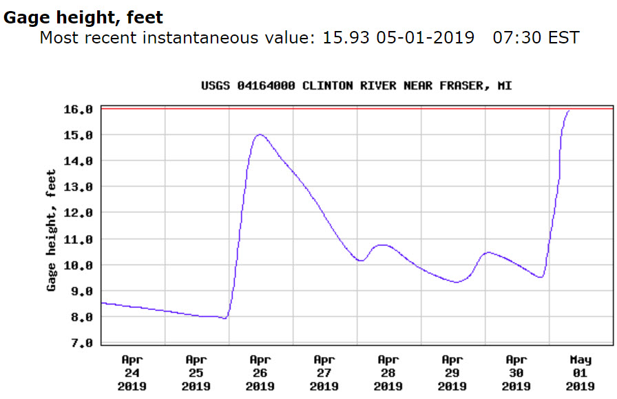
It also had its 3rd consecutive week of Sewage Overflow events.
An overflow means it went somewhere "else" from where it was
original intended to go , designed to go normally.
Last edited by O3H; May-01-19 at 08:48 AM.
-
May-01-19, 08:48 AM #18
DetroitYES Member
- Join Date
- Mar 2009
- Posts
- 283
From The Eastside Community Network @ECNDetroit Facebook page:
"Neighbors! Our friends and neighbors in D4 are facing an historic flood that happens every ten years and is threatening their homes and property. They NEED OUR HELP!!Please join D4 staff and the city of Detroit in helping fill sandbags for houses in the Jefferson Chalmers neighborhood. Volunteers are asked to commit time between 2 and 8pm, working in 2 hour shifts in the AB Ford parking lot. The Army Corps will be joining in these efforts, providing training on proper filling of sandbags and building of a reliable barrier.
For more information, please text Letty Azar, D4 District Manager at 313-236-3518.
Thank you in advance for either showing up or spreading the word."
https://www.clickondetroit.com/news/...iKfHh0KrLswrAw
-
May-01-19, 09:37 AM #19
DetroitYES Member
- Join Date
- Mar 2017
- Posts
- 1,639
Dearborn Heights

-
May-01-19, 09:59 AM #20
DetroitYES Member
- Join Date
- Mar 2009
- Posts
- 283
Windmill Pointe Park
-
May-01-19, 02:07 PM #21
DetroitYES Member
- Join Date
- Mar 2009
- Posts
- 1,355
Originally Posted by O3H
Even at today's high flow rate of 5150 cfs [[Cubic feet per second) the Clinton River is dumping into Lake St. Clair less than 1/2 of 1% of what the St. Clair River does on average. The runoff into the Clinton may be responsible for flooding along the river itself, but it isn't what is causing the flooding issues for lake front residents.
I'm sure with enough investment we can even out the flow by requiring more retention basins, permeable surfaces, etc but the Clinton River is the natural drainage basin for almost all of the Northern Detroit suburbs.The idea that we can somehow fight gravity over a multi county area and not send this water into Lake St. Clair is slightly odd.
-
May-01-19, 06:54 PM #22
DetroitYES Member
- Join Date
- Mar 2017
- Posts
- 1,639
What is ODD and WHACKED and just plain STUPID
-- is mixing the rain water with sewage from peoples toilets !!!!
All across the country they have a true SEWER system for the toilets,
which flows to a full blown actual Waste Water Treatment Plant that expels - wait for it - drinkable water - potable water
All across the country they have true STORMWATER DRAINS for the rain falling from the sky and they route it to the rivers and lakes.
Places like OAKLAND COUNTY thought they would go dirt bagger cheap,
only 1 pipe for BOTH and absolutely NO true Waste Water Treatment Plant. How about that for a fact. A retention basin doesn't discharge drinking water, never has, never will. It merely attempts to hold it [[retain) until it OVERFLOWS and then all hell breaks loose, as it goes into the rivers and lakes. A total of 14 Communities involved in this mayhem.
This is NOT a WWTP -- but toilet water flows right to it.

Macomb County has its own little itty bitty problem to deal with
- in addition to what Oakland dumps into it and flows to the lake
https://www.wxyz.com/homepage-showca...s-to-spend-30m
YEP, those sand bags will be contaminated with sewage.
Where will they dump the smelly, sewage infested bags when they are done ????????
Rain, causing pain for may in metro Detroit
https://www.clickondetroit.com/news/..._content=wdiv4Last edited by O3H; May-01-19 at 07:28 PM.
-
May-02-19, 11:26 AM #23
DetroitYES Member
- Join Date
- Mar 2009
- Posts
- 8,170
I've been listening to flood reports on WWJ radio this morning. They kept reporting that the Southfield was being bailed but they weren't making any progress because the storm drain system was saturated!
Yikes!
-
May-03-19, 04:08 PM #24
DetroitYES Member
- Join Date
- Mar 2017
- Posts
- 1,639
Nothing quite like waiting 72 hours + for the DEQ to release public info.
Perhaps people want to kayak or canoe the Clinton River in MtClemens
this weekend when the sun comes out, some water recreation ??

The International Association for Great Lakes Research [[IAGLR)
is a scientific organization made up of researchers.
IAGLR article , as seen September 13, 2011 :
~ “””over a half-century worth of sediments of significant polluted
sediments appears to be preserved below depths that have been remediated.
When these polluted sediments are stirred up by storm and boat activity,
they might be carried out to Lake St. Clair where much of the Detroit area
receives their drinking water and about a third of all Great Lakes fish are caught“” ~
-
May-03-19, 06:14 PM #25
DetroitYES Member
- Join Date
- Mar 2009
- Posts
- 9,407
Fortunately most of Southfield is in the Rouge River system.... Originally Posted by Jimaz
https://www.bloomfieldtwp.org/PDFFor...atersheds.aspx

 Reply With Quote
 Posting Permissions
Instagram
DetroitYES navigation
DetroitYES Management
© AtDetroit LLC 2000 - 2024 unless otherwise specified. Please notify us of uncited proprietary content.
Welcome to DetroitYES! Kindly Consider Turning Off Your Ad BlockingX
DetroitYES! is a free service that relies on revenue from ad display [regrettably] and donations. We notice that you are using an ad-blocking program that prevents us from earning revenue during your visit.
Ads are REMOVED for Members who donate to DetroitYES! [You must be logged in for ads to disappear]
Ads are REMOVED for Members who donate to DetroitYES! [You must be logged in for ads to disappear]
DONATE HERE »
And have Ads removed.
And have Ads removed.
Bookmarks