


Where do you go for old maps - Library of Congress ?
1915 Detroit Wayne County
https://www.loc.gov/resource/g4113w.la002115/
1894 Wayne County parts of Oakland/Macomb
https://www.loc.gov/resource/g4113w.la000365/
Results 1 to 11 of 11
Thread: Old maps of Detroit
-
November-24-17, 06:59 PM #1
 DetroitYES Member
- Join Date
- Mar 2017
- Posts
- 1,639
 Old maps of Detroit
Last edited by O3H; November-24-17 at 07:01 PM.
-
November-25-17, 10:58 AM #2
DetroitYES Member
- Join Date
- Apr 2009
- Posts
- 87
Thanks. These are really good.
-
November-25-17, 02:50 PM #3
DetroitYES Member
- Join Date
- Mar 2009
- Posts
- 2,160
Online archives and websites
eBay
Antique stores
Used book stores
Estate sales
-
November-25-17, 05:28 PM #4
DetroitYES Member
- Join Date
- Mar 2017
- Posts
- 1,639
Quality, authenticity, legibility, and ability to zoom in are vital to maps
U.S.G.S. - united states geological survey
https://imgur.com/NckRSOnLast edited by O3H; November-25-17 at 05:30 PM.
-
November-25-17, 07:24 PM #5
DetroitYES Member
- Join Date
- Mar 2009
- Posts
- 354
-
November-26-17, 10:31 AM #6
DetroitYES Member
- Join Date
- Dec 2011
- Posts
- 338
Yes. To see how amazingly detailed they are, check out this Sanborn map of the Packard plant: Originally Posted by Crystal

https://www.loc.gov/resource/g4114dm...5194907/?sp=44
-
November-26-17, 07:40 PM #7
DetroitYES Member
- Join Date
- Mar 2009
- Posts
- 354
Kiraly, thank you so much for the wonderful map of Packard. I'm not the best at locating specific structures, and to see the plant in such detail is great fun.
In another Sanborn project I found myself [[at long last) locating the massive J & L Steel plants in Pittsburgh and Aliquippa, Pennsylvania. Wow, one could pore over those detailed drawings for hours.
-
November-26-17, 09:40 PM #8
DetroitYES Member
- Join Date
- Mar 2009
- Posts
- 217
Here's a link to a high res scan that I did of a mid 1930s map of Detroit:
https://get.google.com/albumarchive/...iKx3AtpF7Gm3AL
Use the scroll wheel or CTRL+ to enlarge if viewing online.
-
November-27-17, 10:16 AM #9
DetroitYES Member
- Join Date
- Mar 2009
- Posts
- 3,184
Those maps really conjured up my historical "what ifs". Had we not given birth to the auto industry would our city limits be different? Detroit's boundaries remind me of Old Toronto. I assume we expanded because we wanted to capture the tax base of growing population and commercial centers but if auto plants didn't exist that wouldn't have happened so fast.
Perhaps the city limits in the OP's post would be much more urban. Traffic relief would've come in the form of real mass transit. The true inner suburbs would've started around Six or Seven Mile. Suburbs like Woodward Heights, Gratiot Heights, or Connor Creek never to be...
-
November-28-17, 01:31 AM #10
DetroitYES Member
- Join Date
- Apr 2009
- Posts
- 4,513
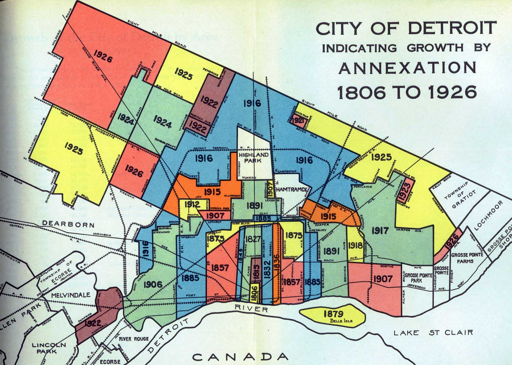
Map of Detroit's expansion:
-
December-04-17, 12:37 AM #11
DetroitYES Member
- Join Date
- Mar 2017
- Posts
- 1,639
Great stuff, never looked at Detroit in quite that manner before.
Thank You for posting

 Reply With Quote
 Posting Permissions
Instagram
DetroitYES navigation
DetroitYES Management
© AtDetroit LLC 2000 - 2024 unless otherwise specified. Please notify us of uncited proprietary content.
Welcome to DetroitYES! Kindly Consider Turning Off Your Ad BlockingX
DetroitYES! is a free service that relies on revenue from ad display [regrettably] and donations. We notice that you are using an ad-blocking program that prevents us from earning revenue during your visit.
Ads are REMOVED for Members who donate to DetroitYES! [You must be logged in for ads to disappear]
Ads are REMOVED for Members who donate to DetroitYES! [You must be logged in for ads to disappear]
DONATE HERE »
And have Ads removed.
And have Ads removed.
Bookmarks