


http://www.freep.com/story/news/colu...hood/80866138/
This is the state of the James Smith farmhouse, the citys oldest cabin and its second-oldest house, located on Clements near 14th Street on the citys west side. Built as long ago as the 1830s, it's a small, one-and-a-half story box that sits partly hidden and largely unknown in a fading neighborhood dotted with abandoned homes, tucked between two old houses that shield it from view. A small historical plaque offers the only clue that theres something special about it.
Results 1 to 25 of 50
-
February-28-16, 07:24 PM #1
 DetroitYES Member
- Join Date
- Mar 2009
- Posts
- 2,606
 Detroit's Oldest Cabin Lies Hidden in a Neighborhood
-
February-28-16, 10:29 PM #2
DetroitYES Member
- Join Date
- Mar 2009
- Posts
- 8,166
What a find! Originally Posted by Pam

That it sets at such an odd angle relative to its surroundings suggests the unsolved mystery: What accounts for that disclination? To what other grid was it originally aligned? And how can that crooked chimney still stand?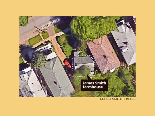
Street view
-
February-28-16, 11:10 PM #3
DetroitYES Member
- Join Date
- Feb 2014
- Posts
- 2,239
I can't answer for the chimney but the other grid is 'Public Land Survey System'. [[also refereed to as Township and Range). Eight mile was the Base Line for the system explaining the north south orientation. I wonder how much acreage the original farmer worked. Originally Posted by Jimaz
https://en.wikipedia.org/wiki/Public_Land_Survey_SystemLast edited by ABetterDetroit; February-28-16 at 11:20 PM.
-
February-28-16, 11:25 PM #4
DetroitYES Member
- Join Date
- Mar 2009
- Posts
- 45
However this land and it's subdivision is within the 10,000 acre tract which predacted the PLSS. The subdivision was platted in 1916 and this house sits on a 35 foot wide lot just like every other one in the block. Either it was already like that [[unlikely to fit in the plat so well) or it wasmoved when the neighborhood was developed. Either way a good question as to why it is laid out how it is! Originally Posted by ABetterDetroit
-
February-28-16, 11:47 PM #5
DetroitYES Member
- Join Date
- Feb 2014
- Posts
- 2,239
Not sure what you mean. Define "predacted"? The house was there long before 1916 and almost all farm land in Michigan in 1820-1850 was surveyed and sold under PLSS.
-
February-29-16, 12:39 AM #6
DetroitYES Member
- Join Date
- Apr 2009
- Posts
- 4,513
Predated is what was meant. Almost all land in Michigan was surveyed in a directional grid and sold under the PLSS, but perhaps the biggest exception to that were the parts of Detroit that had already been laid out in an orientation based on the course of the Detroit River. Originally Posted by ABetterDetroit
Included in that previously surveyed area is the Ten Thousand Acre Tract, which was granted to Detroit by Congress in 1806 in reaction to Judge Woodward's and Governor Hull's pleadings to defray many of the costs after the 1805 fire. It looks like the location of this house falls within that tract.
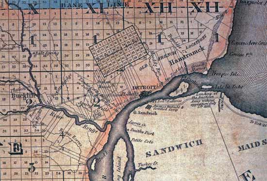
The 10,000 Acre Tract is the large rectangle in the middle of this survey map. It's northern boundary is a couple of blocks north of today's Davison, right around where this house is.
Here is an old thread on it:
http://www.atdetroit.net/forum/messa...tml?1173667967Last edited by EastsideAl; February-29-16 at 12:44 AM.
-
February-29-16, 01:18 AM #7
DetroitYES Member
- Join Date
- Apr 2009
- Posts
- 4,513
Here is an 1876 map of the Smith farm, which may hold some clues about the orientation of the house.
To orient you, the "Pontiac Road" on the east of the map is Woodward. I believe that the black boundary line on the southern edge of the Smith farm is where Davison is today, and the northern edge is just a little north of Oakman. I think the road to the east of the farm is now Rosa Parks Blvd. [[12th St.). Note where Fenkell [[5 Mile) seems to begin just to the north.
This map shows 2 structures on the Smith farm [[the black dots). One of them is just north of where I think Davison is now, and the other on a street that no longer exists that appears as if it may be an extension of today's Glendale.
Here is a link to the entire map of what was then Greenfield Township:
http://quod.lib.umich.edu/m/micounty...image&size=400
-
February-29-16, 01:29 AM #8
DetroitYES Member
- Join Date
- Jun 2015
- Posts
- 1,416
Do I spot a plot of land owned by a W. Mouch just above the stream, at the corner of today's Fenkell and Rosa Parks? Originally Posted by EastsideAl
Any relation? Still Alive??
I've only heard of one other centuries old Detroiter, in that Jarmusch film:
https://www.youtube.com/watch?v=-TbxI_oRSKI
Apologies again.Last edited by bust; February-29-16 at 03:06 AM.
-
February-29-16, 01:38 AM #9
DetroitYES Member
- Join Date
- Apr 2009
- Posts
- 4,513
And here's a map of the same area from 1904. Highland Park is now growing to the east. The Smith land has been split between Hannah Smith and E. Ford. Only one structure shows there now on this map, a house on the E. Ford land that appears to be near the no longer existing extension of Glendale. Could this be the house that's still there today, and could the siting of the current structure still be oriented to the the diagonal orientation of old Glendale?
Here's the map of Greenfield Township that this was taken from:
http://quod.lib.umich.edu/m/micounty...image&size=400Last edited by EastsideAl; February-29-16 at 02:58 PM.
-
February-29-16, 12:10 PM #10
DetroitYES Member
- Join Date
- Feb 2014
- Posts
- 2,239
I stand corrected. I bow to the Detroit history knowledge of fareastsider and eastsideAl, fascinating stuff, thanks for the maps. They answered my question of the size of the farm.
-
February-29-16, 12:59 PM #11
DetroitYES Member
- Join Date
- Apr 2010
- Posts
- 1,181
You can find this Picturesque Detroit and its Environs, on Google books. Photo of the farmyard is on page 26.
-
February-29-16, 03:30 PM #12
DetroitYES Member
- Join Date
- Apr 2009
- Posts
- 4,513
That sly ol' Wesley. He never let on that he was a land tycoon. Owning what's now such prime Lodge Freeway frontage. Originally Posted by bust
-
February-29-16, 03:32 PM #13
DetroitYES Member
- Join Date
- Apr 2009
- Posts
- 4,513
That's a great find. Love the pig! Originally Posted by mikefmich
If I had to guess, I'd say that the part of the house that now faces the street on Clement was actually the back side, and that the old front porch shown here was probably on the other side.
-
March-01-16, 08:24 PM #14
DetroitYES Member
- Join Date
- Mar 2009
- Posts
- 45
The link to the plat is below. The cabin is on lot 68. Judging by the fact that there is no deviation from the lot in the middle of the block from many other in the plat I have to imagine it was placed there. Many times on plats you can see either a larger lot or the plat wrap around the original house on a farm parcel and it typically would not be included in the plat. What ever the history its always great to find another hidden historical location in the city!
http://www.dleg.state.mi.us/platmaps..._SUBINDEX=2317
-
March-02-16, 10:26 AM #15
DetroitYES Member
- Join Date
- Mar 2009
- Posts
- 1,090
Al, a house I work on near Fenkell on Evergreen indicates on the original plat "12th Street" rather than Fenkell. It is from the early 30s. Originally Posted by EastsideAl
-
March-02-16, 02:35 PM #16
DetroitYES Member
- Join Date
- Mar 2009
- Posts
- 6,543
A 180 year old home in the Detroit ghetto-hood and nobody knows about it. It stood against robberies, squatters and even arson. I hope the folks in that area are doing what ever it can to save it. That's amazing.
-
March-05-16, 11:07 PM #17
DetroitYES Member
- Join Date
- Mar 2009
- Posts
- 1,090
Originally Posted by EastsideAl
Upon closer examination, it appears that what is marked Plymouth Road is in fact modern day West Chicago. Is it mismarked? Did they change? Judging by the railroad tracks at Fullerton and the fact that the southern boarder of Greenfield Twp appears to be Tireman, something appears odd.....
-
March-06-16, 04:34 PM #18
DetroitYES Member
- Join Date
- Apr 2009
- Posts
- 4,513
You are correct. The "new" Plymouth Road was built in the early '20s as part of the automotive friendly widening, rebuilding, rerouting, and rationalizing of Detroit and Wayne County roads [[same time as Outer Drive was built, and Vernor Hwy. was linked up across the city). The old Plymouth Rd. [[W. Chicago) was cut off by the Rouge River, and travelers had to jog north on what's now Evergreen to get to the the road that crossed the Rouge and actually went to Plymouth [[on the alignment of today's Plymouth Rd.). The new, wide Plymouth Rd. linked Grand River directly to this more northerly road, and was cut through the then brand-new Rouge Park. Originally Posted by Hamtragedy
-
March-06-16, 08:26 PM #19
DetroitYES Member
- Join Date
- Jul 2009
- Posts
- 4,859
Wonder if the dude sitting on the porch knows what he lives next to?
-
March-06-16, 09:06 PM #20
DetroitYES Member
- Join Date
- Jan 2012
- Posts
- 414
-
March-06-16, 10:55 PM #21
DetroitYES Member
- Join Date
- Aug 2012
- Posts
- 8,853
Even back then, people were into aluminum siding, imagine that. Originally Posted by Meddle
-
March-07-16, 12:26 AM #22
DetroitYES Member
- Join Date
- Sep 2010
- Posts
- 72
This is fascinating. I love this lost history stuff.
-
March-07-16, 07:13 AM #23
DetroitYES Member
- Join Date
- Mar 2009
- Posts
- 6,543
Little House in the Ghetto! That would be a great TV serious.
-
March-07-16, 07:58 AM #24
DetroitYES Member
- Join Date
- Aug 2012
- Posts
- 8,853
Nice!..... Originally Posted by Danny

-
March-07-16, 04:43 PM #25
DetroitYES Member
- Join Date
- Oct 2009
- Posts
- 1,557
Just for it's own protection, move it to Greenfield Village.

 Reply With Quote
 Posting Permissions
Instagram
DetroitYES navigation
DetroitYES Management
© AtDetroit LLC 2000 - 2024 unless otherwise specified. Please notify us of uncited proprietary content.
Welcome to DetroitYES! Kindly Consider Turning Off Your Ad BlockingX
DetroitYES! is a free service that relies on revenue from ad display [regrettably] and donations. We notice that you are using an ad-blocking program that prevents us from earning revenue during your visit.
Ads are REMOVED for Members who donate to DetroitYES! [You must be logged in for ads to disappear]
Ads are REMOVED for Members who donate to DetroitYES! [You must be logged in for ads to disappear]
DONATE HERE »
And have Ads removed.
And have Ads removed.
Bookmarks