


Thought I'd through a little historical question out to DYessers. Historically, Corktown's western border was generally 12th/Rosa Parks, though, the definition seems to have changed to also include most everything west of 12th and north of the railroad tracks [[basically, the few blocks around Michigan Central Station) to the Fisher as part greater Corktown.
My question is whether or not the area west of 12th - and more particularly south of the railroad tracks/"behind" MCS - to about the bridge had any indentity as its own? Was it known as anything specific? Even now, it still seems a bit much to refer to this area as even being a part of either Mexicantown [[which starts on the other side of the freeway and bridge) or Corktown. Though, with the Mexican population having spilled across the bridge, it's probably more culturally a part of Mexicantown. Still, I don't think any of the Mexicantown or Southwest Detroit business associations represent this little "inbetween" neighborhood.
Thoughts?
Results 1 to 15 of 15
Thread: West of Corktown
-
February-13-15, 10:15 AM #1
 DetroitYES Member
- Join Date
- Sep 2011
- Posts
- 875
 West of Corktown
-
February-13-15, 10:28 AM #2
DetroitYES Member
- Join Date
- Feb 2010
- Posts
- 4,216
I think it should heretofore be known as Mexicorktown.
-
February-13-15, 10:32 AM #3
DetroitYES Member
- Join Date
- Sep 2011
- Posts
- 875
I'm kind of partial to Corxicantown, myself.

-
February-13-15, 11:45 AM #4
DetroitYES Member
- Join Date
- Apr 2009
- Posts
- 4,513
First of all, I would think of that area as Ste. Anne's parish. The neighborhood has centered around the church since the "new" building of Detroit's founding parish [[the second oldest Catholic parish in the U.S.) was built there in 1886.
That was Detroit's original Mexicantown, with a substantial Mexican population going back into the 1920s [[Ste. Anne began holding Spanish masses in 1940). Although Mexican Village and Honey Bee are really all that's left of that era now. It was all one continuous strip on Bagley before the freeway cut it in half in the '60s. After that, most of the business and population drifted over to the west side of the freeway.
Before that though, and really into the mid-20th century, that area was functionally a part of Corktown, with a primarily Irish population. You have to keep in mind that the industrial area south of present-day Corktown was also once part of Corktown. It was a primarily Irish residential neighborhood [[with a smattering of Hispanics, Maltese, and others) until it was "slum cleared" for the industrial park in the 1960s. That south part of Corktown was really contiguous [[via several more bridges over the tracks than exist today) with the area you're talking about.
I had some distant relatives on the Irish side of my family who lived on "fancy" [[for Irish folks in those days) Layfayette Blvd. near the bridge, where part of the freeway runs today.Last edited by EastsideAl; February-13-15 at 11:47 AM.
-
February-13-15, 11:48 AM #5
DetroitYES Member
- Join Date
- Apr 2009
- Posts
- 170
Mexicantown does not start on the other side [[west) of the freeway. The freeway cut the neighborhood in two. The pedestrian bridge was built to try and reconnect the two sides. If you look at the businesses on the east side of the freeway, they are just as Mexican as the west side, including two of the oldest and most popular businesses: Mexican Village Restaurant and La Colmena [[Honeybee) Mercado.
And, yes, while the official western border of Corktown is Rosa Parks Blvd, for as long as I can remember everything east of the railroad tracks, south & east of I-75 is considered Corktown. Many houses in that area have been on the yearly Corktown Home Tour over the past 30 years.
To be very technical and go by the neighborhood borders on Google Maps, the popular restaurant row on Bagley on both sides of the freeway is in Hubbard-Richard, not Mexicantown But no one can argue that you can't include that in Mexicantown.
So for practicality's sake, everything east of the railroad tracks is Corktown and everything west is Mexicantown.
Hubbard-Richard defenders start your attacks now!!Last edited by middetres; February-13-15 at 12:15 PM.
-
February-13-15, 12:58 PM #6
DetroitYES Member
- Join Date
- Jul 2012
- Posts
- 267
However you deduce the correct name and history of the neighborhood, don't give much credence to the names that Google Maps assigns.
http://www.google.com/mapmaker
-
February-13-15, 02:01 PM #7
DetroitYES Member
- Join Date
- Feb 2010
- Posts
- 4,216
 Originally Posted by Dexlin

Is Benny Napoleon an ethnic Corxican?
-
February-13-15, 07:36 PM #8
DetroitYES Member
- Join Date
- Feb 2015
- Posts
- 3
Nowadays, they keep trying to push the border of Corktown further out. Before they opened Two James Spirit, Corktown really only stretched to Michigan & 14th [[once they reopened the Mercury Bar). North of I-75 along Trumbull, 12th & 14th is now North Corktown. Corktown technically pushed down Michigan Avenue to the freeway I-96/Grand Blvd, but near the Hygrade Deli the old Starr Bar is being renovated and an old bank is turned into a house/apts, they are calling that West Corktown. Green Dot Stables opened at Lafayette & 14 St, that's considered Corktown. The train station is also part of Corktown, but if you take Vernor under the bridge around the back of the train station, that whole area is considered Mexicantown. Corktown runs down Bagley til 14th St, but west of the train tracks/16th Street is old Mexicantown, where St. Anne's is at, and what is left at Bagley and 18th [[Mexican Village and Honey Bee La Comena). The borders have changed over the years though. Originally Posted by Dexlin
-
February-13-15, 08:01 PM #9
DetroitYES Member
- Join Date
- Jul 2011
- Posts
- 1,325
Detroitography has a nifty map of the changing boundaries of Corktown.
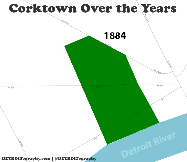
http://detroitography.com/2014/10/06...ver-the-years/
Midtown has gone through a similar neighborhood boundary expansion albeit more recently. I don't think most Detroiters would consider Boston Edison to be apart of Midtown, but due to the fact that Midtown, Inc. offers residential incentives for those to possibly live in BE, that would likely increase the connections between the two areas and make it inevitable for Midtown's de facto area to expand. At one point, I think New Center was considered seperate from Midtown but now is considered just a smaller area within the greater Midtown area.
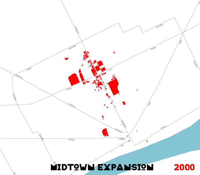
http://detroitography.com/2015/02/02...map-2000-2014/
Anyway, Detroit suffers from being sprawly and very nondescript between major neighborhoods. In many areas, there aren't any major landmarks or defining characteristics which allows neighborhood boundaries to be fuzzy and change constantly. Plus the urban decay and freeways help to separate areas that otherwise might have been considered one neighborhood [[as pointed out in the case of Mexicantown). So the boundaries are forever changing just as the neighborhoods themselves are forever changing.Last edited by animatedmartian; February-13-15 at 08:05 PM.
-
February-13-15, 09:31 PM #10
DetroitYES Member
- Join Date
- Apr 2009
- Posts
- 4,513
Cute graphics, but "Tigers Stadium" makes my eyes hurt.
-
February-13-15, 10:01 PM #11
DetroitYES Member
- Join Date
- Jun 2009
- Posts
- 982
The neighborhood considers itself Corktown from the Lodge to MCS [[both train bridges), and north of MCS until I-75. Any other areas considered Corktown have been decided by folks looking to ride the Corktown name game, to increase property values and desireablity. This includes "Corktown Shores", otherwise known to the rest of the city as "Westside Industrial." The only other exception is North Corktown, and they get a pass because the people who actually live there, and do not work for some money grubbing non-profit, call it that. Although some of the old timers still call it Briggs.
Last edited by detroitsgwenivere; February-13-15 at 10:12 PM.
-
February-13-15, 10:07 PM #12
DetroitYES Member
- Join Date
- Apr 2014
- Posts
- 130
Mine also. That was and still is in my mind Briggs Stadium. I used to walk by it often when I was a kid. Originally Posted by EastsideAl
-
February-14-15, 01:02 AM #13
DetroitYES Member
- Join Date
- Sep 2011
- Posts
- 875
Well, that, and because this area was actually part of Corktown prior to the freeway cutting it off. It's really sad how little is left of this area, it has to be one of the emptier quarters of the city. Of the area in the little "square" or island created by the Fisher, Lodge, Jeffries and Ford, only Woodbridge intact as a neighborhood in any discernable way. Originally Posted by detroitsgwenivere
-
February-14-15, 12:32 PM #14
DetroitYES Member
- Join Date
- Apr 2009
- Posts
- 4,513
Hilarious. And I think back to how much trouble my grandmother went to to make the distinction clear to all who would hear her that our family couldn't, under any circumstances, be considered "Corktown Irish". Originally Posted by detroitsgwenivere
-
February-16-15, 04:28 AM #15
DetroitYES Member
- Join Date
- Sep 2011
- Posts
- 875
Speak of the devil. I was just searching for something else, and inadvertendly came across and old Free Press clipping from just a bit over 30 years ago.

It shows the Corktown Historic District, which is a narrow property-by-property definition which is on the National Register of Historic Places, and the proposed expansion of this historic district to properties to the west of the core of the district. What's most telling is the Freep's own designation of Corktown [[inside the dotted line) in the 80's. They have it stretched all the way to Michigan Central Station, but it stays totally north/east of the railroad tracks.
Just thought you guys might be interested in seeing this. I also noted now much north of Michigan was still intact when this article was written.

 Reply With Quote
 Posting Permissions
Instagram
DetroitYES navigation
DetroitYES Management
© AtDetroit LLC 2000 - 2024 unless otherwise specified. Please notify us of uncited proprietary content.
Welcome to DetroitYES! Kindly Consider Turning Off Your Ad BlockingX
DetroitYES! is a free service that relies on revenue from ad display [regrettably] and donations. We notice that you are using an ad-blocking program that prevents us from earning revenue during your visit.
Ads are REMOVED for Members who donate to DetroitYES! [You must be logged in for ads to disappear]
Ads are REMOVED for Members who donate to DetroitYES! [You must be logged in for ads to disappear]
DONATE HERE »
And have Ads removed.
And have Ads removed.
Bookmarks