


I love the DTE Aerial photos that we so often reference. I found a much better way to view the 1949 Wayne County map as a continuous map. Some of the stitching is a little off, but for the most part it's pure awesomeness.
Enjoy!
http://gigapan.com/gigapans/147450

Results 1 to 24 of 24
-
July-02-14, 08:25 AM #1
 DetroitYES Member
- Join Date
- Feb 2010
- Posts
- 3,901
 Wayne County 1949 DTE Aerial Photos - Stitched Together!
-
July-02-14, 09:57 AM #2
DetroitYES Member
- Join Date
- May 2010
- Posts
- 533
Well done 307...my personal favorite is the lower eastside waterfront environs across from Pesche Island.
-
July-02-14, 10:04 AM #3
DetroitYES Member
- Join Date
- Feb 2010
- Posts
- 3,901
Thanks, to be clear, this wasn't my work, I just found it and got absurdly excited. Originally Posted by EASTSIDE CAT 67-83

-
July-02-14, 10:40 AM #4
DetroitYES Member
- Join Date
- Jul 2011
- Posts
- 1,325
Nice find. Such a lovely pre-freeway street grid.
-
July-02-14, 10:49 AM #5
DetroitYES Member
- Join Date
- Feb 2010
- Posts
- 3,901
Yup, I was only able to find the Davison. Originally Posted by animatedmartian
-
July-02-14, 11:14 AM #6
DetroitYES Member
- Join Date
- Feb 2010
- Posts
- 1,629
Very interesting that even parts of Wyandotte are still farmland.
-
July-02-14, 11:19 AM #7
DetroitYES Member
- Join Date
- Apr 2009
- Posts
- 267
I love looking at these old pictures of neighborhoods before the highways went thru them and I am always amazed at the eastside with houses on all the lots
-
July-02-14, 11:40 AM #8
DetroitYES Member
- Join Date
- Jul 2011
- Posts
- 1,325
I noticed the Detroit Industrial Expressway that'd eventually become I-94. You can see construction of the Michigan Avenue interchange and a few blocks being cleared to the east of it. Originally Posted by 48307
Last edited by animatedmartian; July-02-14 at 11:47 AM.
-
July-02-14, 11:44 AM #9
DetroitYES Member
- Join Date
- Mar 2009
- Posts
- 8,166
That aerial has a very smooth scroll.
Good job!This photo consist of a collection of ~590 aerial photos from 1949 of Wayne county Michigan which includes the City of Detroit. Photo Credits: Individual photos were provided by DTE to the Wayne State University.
We looked up our older homestead on the original DTE photos and discovered that our driveway once curved into a room we now call the den. The current detached garage had not yet been added. We had no hint that the old garage was inside the house until we saw those photos. During later remodeling we discovered a low cinderblock wall surrounding just that one room.
Archeology-atcha!
-
July-02-14, 12:13 PM #10
DetroitYES Member
- Join Date
- Mar 2009
- Posts
- 6,543
That was Detroit before the super sprawl. Livonia at the time was mostly open farmland. The only sprawl that city had is North Rosedale Gardens.
-
July-02-14, 12:15 PM #11
DetroitYES Member
- Join Date
- Apr 2009
- Posts
- 5,875
Very nice.
Resolution is not bad considering the technology of the time. There are some places where there are some matching issues, but that too is to be expected when combining several photos. When you are dealing with stuff that old and not in digital formats, it is to be expected.
-
July-02-14, 01:09 PM #12
DetroitYES
- Join Date
- Feb 2009
- Posts
- 6,776
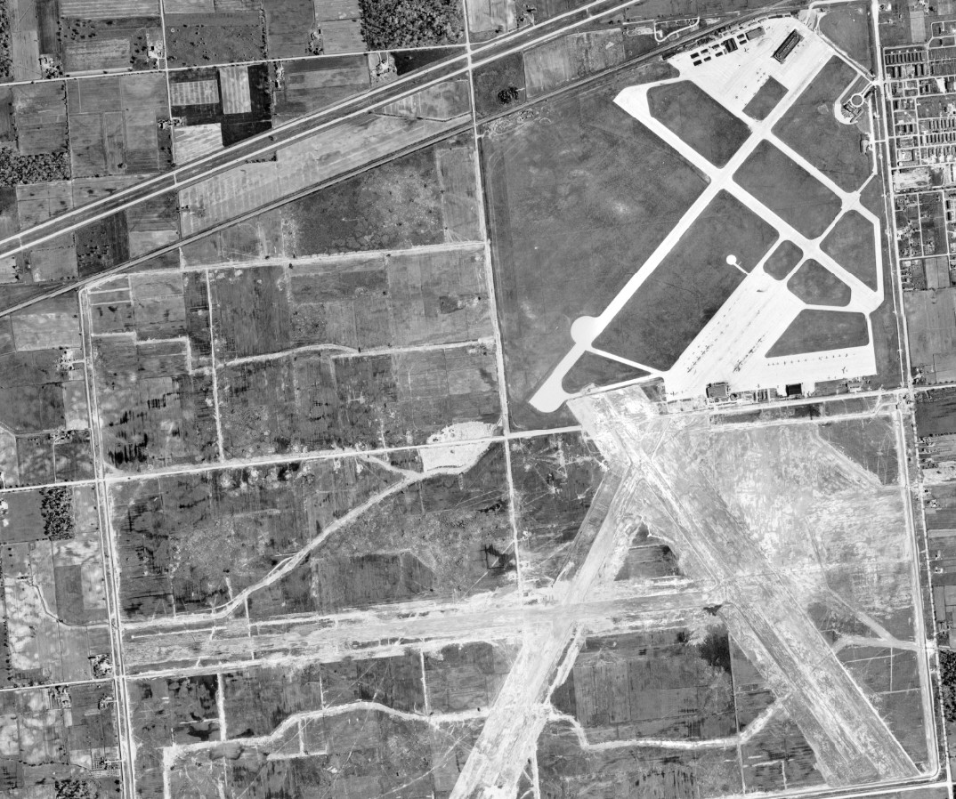
Interesting find. There is some distortion. Woodward kind of ends around McNichols, maybe some parallax in the images.
Here is a snippet of DTW building its new runways for the jet age.
-
July-02-14, 05:50 PM #13
DetroitYES Member
- Join Date
- Mar 2009
- Posts
- 30
Notice that there are also tracks running along mulberry st going where the current hospital is today. Originally Posted by mtburb
-
July-02-14, 09:28 PM #14
DetroitYES Member
- Join Date
- Sep 2011
- Posts
- 875
How large a file is this? I ask, because as someone on an older computer and operating system, I don't want to attempt to open something that'll crash my browser.
-
July-03-14, 12:53 AM #15
DetroitYES Member
- Join Date
- Jul 2011
- Posts
- 1,325
It's in a flash player so it should be more like how it loads when you go on to google maps. Originally Posted by Dexlin
-
July-04-14, 03:12 AM #16
DetroitYES Member
- Join Date
- Mar 2012
- Posts
- 902
You can see the start of freeways by looking at Northwestern Hwy in the top left of the map. Southfield is a similar large boulevard up until Grand River.
-
July-04-14, 09:01 AM #17
DetroitYES Member
- Join Date
- Mar 2009
- Posts
- 729
It is crazy how much of the parking behind the Fox thatg we complain about today was actually parking back then too.
-
July-04-14, 09:22 AM #18
DetroitYES Member
- Join Date
- Feb 2010
- Posts
- 1,629
I wonder if something similar has been done with the 1997 aerials-but there would be a huge roadblock with that-nearly all Downriver images instead redirect to 404 errors when attempting to access them.
-
July-04-14, 10:16 AM #19
DetroitYES Member
- Join Date
- Jul 2014
- Posts
- 2
Amazing photo!
Loved that lower east side too, all the way down to Lakewood park. Amazing photo!
Originally Posted by 48307
-
July-04-14, 11:06 AM #20
DetroitYES Member
- Join Date
- Jan 2014
- Posts
- 401
I had the exact same thought, really surprising to me. Originally Posted by gumby
-
July-04-14, 11:52 AM #21
DetroitYES Member
- Join Date
- Jul 2011
- Posts
- 1,325
The exodus from downtown started pretty early. The Great Depression is what mostly contributed to it as well as general changes in demographics. I believe that area of Cass Corridor/Park Avenue was mostly built with hotels and luxury apartments. So of course when the affluent left for greener pastures, the area quickly turned into a skid row by the middle of the century.
-
July-04-14, 12:08 PM #22
DetroitYES Member
- Join Date
- Apr 2012
- Posts
- 1,071
Fascinating. I feel like people that lived back then could really tell us a lot about Detroit that we've forgotten. To see Delray and lower Cass so populated... wow. It's truly a lost world.
-
July-04-14, 01:54 PM #23
DetroitYES Member
- Join Date
- Jul 2011
- Posts
- 1,325
It wasn't really all that different that what you might hear people say in the big cities of today. I remember a poster in another forum saying that their parents, during the 1930s, thought Detroit was too crowded and could never bother to live here with all the noise and traffic. Of course there was probably tons of other people who loved it. And then too there was probably a lot more diversity because of immigrants than their is today.
I've seen a few videos from during that time period, and yea... Detroit pretty much seemed like the big city 2nd to Chicago. It's definitely hard to imagine it now.
-
July-05-14, 02:03 AM #24
DetroitYES Member
- Join Date
- Mar 2009
- Posts
- 1,493
You can see the horse track from the Dahlinger Estate.

 Reply With Quote
 Instagram
DetroitYES navigation
DetroitYES Management
© AtDetroit LLC 2000 - 2024 unless otherwise specified. Please notify us of uncited proprietary content.
Welcome to DetroitYES! Kindly Consider Turning Off Your Ad BlockingX
DetroitYES! is a free service that relies on revenue from ad display [regrettably] and donations. We notice that you are using an ad-blocking program that prevents us from earning revenue during your visit.
Ads are REMOVED for Members who donate to DetroitYES! [You must be logged in for ads to disappear]
Ads are REMOVED for Members who donate to DetroitYES! [You must be logged in for ads to disappear]
DONATE HERE »
And have Ads removed.
And have Ads removed.
Bookmarks