


Quick, random question, but what's the history behind John R becoming the east-west dividing road north of Highland Park? When did it become the divider, and did it exist before or after Woodward as the divider?
Results 1 to 19 of 19
Thread: John R History
-
April-03-12, 07:53 PM #1
 DetroitYES Member
- Join Date
- Sep 2011
- Posts
- 875
 John R History
-
April-04-12, 07:32 PM #2
DetroitYES Member
- Join Date
- Mar 2009
- Posts
- 104
"The Street Of Music"
I can tell you about the musical history of John R, dubbed "the street of music" in the mid-40's by Detroit's Black press. This relates to Detroit's AA population moving North and west; Hastings Street was becoming, to paraphrase a contemporary columnist, "a bit shopworn."
So John R roughly between Hancock and Watson flourished. Several hotels, like the Garfield and Sonny Wilson's Mark Twain Hotel as well as the Gotham [[said to be the finest hotel for American Africans in Det) did good biz. The late forties saw the openiing of the Flame Show Bar [[THE main outlet for Black entertainment in Detroit during the fifties), the Frolic Show Bar, the Chesterfield Lounge, and several other clubs proximate to John R, like the Parrot. The Civic Center Ballroom, now housing the Masons at John R and Erskine, is the sole remnant of what must've been a hell of a chapter.
John R / Flame Show Bar are the roots of Motown Records.
As the sixties progressed [[or, regressed) boomers didn't want to patronize Show Bars and instead spread out across the city, dancing to the Motown Beat. What's ironic is that Berry Gordy and his fam had the photo concession at the Flame, and later at the Frolic, and thru that Berry met tons of musicians and vocalists like Jackie Wilson. They sang his songs, he opened Motown, etc. Berry's contacts at the Flame were used to help tear down those clubs and hasten the end of an era.
The Frolic was still goin' in 1968, featuring jazz, but that was a last gasp of The Street of Music.
We have a presentation titled, "The Roots of Motown" which uses many very cool and rare pix and music, too, including the Four Tops from 1956 [[on Chess), around the time they played the Frolic Show Bar.Last edited by Jimg; April-04-12 at 07:40 PM.
-
April-04-12, 08:14 PM #3
DetroitYES Member
- Join Date
- Apr 2009
- Posts
- 5,875
Its simple geometry. Don't know much about history.... Originally Posted by Dexlin


-
April-05-12, 03:00 AM #4
DetroitYES Member
- Join Date
- May 2010
- Posts
- 342
I guess this answers it partially.
http://stevemorse.org/census/changes/RenumInfo.htm
Detroit, the 4th largest city in the United States in 1920, underwent a massive house renumbering program in 1921. The new numbers went into effect on January 1, 1921. The tables presented on our utility were transcribed from the “Federal Official Street Guide and Pocket Directory of Detroit,” 1920-21 Edition.
Here is what the Directory says about the new numbering system:
One full number is allowed for each 10 feet of frontage on each side of all
Thoroughfares, even numbers on the right and odd numbers on the left
side. The base line is a line drawn perpendicular with the foot of Woodward
Avenue, extending easterly through Essex Avenue and in a westward direction
along the tracks of the Wabash Railroad: streets south of this line will be
“south.” Woodward Ave to the Six Mile Road and thence continuing north
on John R Street will be the other base line dividing the city into “East,” and
“West.” Michigan Avenue is considered as extending westward, Grand River
Avenue northward and Gratiot Avenue eastward, for the purpose of the
ordinance. North and south streets start at the base line with the numbers 100
and 101: east and west streets start at the Woodward base line with numbers
1 and 2. Each block will be a rectifying block, so that along a north and south
line from the river up, the numbers on the houses will be alike on each cross
street: the same holds true going east and west.
-
April-05-12, 04:52 AM #5
DetroitYES Member
- Join Date
- Sep 2011
- Posts
- 875
Thanks for the effort, Brock. Though, I must admit that that piece actually brings even more questions than it answers, such as: where in the hell is "Essex Avenue?" lol And, then it just kind of nonchalantly states that the east-west divider just totally switches to John R at Six Mile with no explanation. Originally Posted by Brock7
Maybe it had something to do with the township boundaries at the time? I mean, I'm sure I'm not the only one that has wondered why Woodward doesn't remain the divider all the way to 8 Mile. I'd never call Grixdale Farms and Chaldean Town "west side" even though the address divide makes them so.Last edited by Dexlin; April-05-12 at 04:57 AM.
-
April-05-12, 06:42 AM #6
DetroitYES Member
- Join Date
- May 2010
- Posts
- 342
Here's where Essex is now, don't know about 1921.
Essex St & Tennessee St, Detroit, Wayne, Michigan 48215Last edited by Brock7; April-05-12 at 06:47 AM.
-
April-05-12, 01:05 PM #7
DetroitYES Member
- Join Date
- Apr 2009
- Posts
- 4,513
That's the same Essex, 2 blocks south of Jefferson. My grandparents lived for many years on Chalmers between Essex and Avondale. Their address was a "south" address for a while, but at some point the city got rid of the distinction on the east side [[it only covered a few blocks anyway). I believe it still exists on the westside though, primarily in Delray.
-
April-05-12, 01:18 PM #8
DetroitYES Member
- Join Date
- Mar 2009
- Posts
- 4,317
Woodward and John R are parallel until Six Mile, heading northwesterly, then John R straightens out and heads due north. Woodward continues on its northwesterly course. Keeping the divider at John R made sense geographically.
-
April-05-12, 01:22 PM #9
DetroitYES Member
- Join Date
- Sep 2011
- Posts
- 779
Does that mean that all the north-south addresses on the east side were changed again after 1921? If, for example, the house on the NW corner of Chalmers and Essex went from 101 North Chalmers to 501 Chalmers, wouldn't every address on Chalmers all the way up to Seven Mile have to be bumped up by 400 as well? Originally Posted by EastsideAl
-
April-05-12, 01:54 PM #10
DetroitYES Member
- Join Date
- Apr 2009
- Posts
- 4,513
Yes, several blocks on the eastside were renumbered again after 1921. However,, the 1921 addresses jumped from 500 to 1000 at Jefferson, so only the blocks south of Jefferson were renumbered. Originally Posted by antongast
So, for example, my grandparent's house, which had been 136 S. Chalmers [[all these addresses are approximate as I don't remember the actual addresses anymore) was renumbered to 476 Chalmers. My aunt later bought a house further up Chalmers between Freud and Jefferson, years after these address changes had been made. Her house was numbered in the 800s, but there were still old numbers painted on the house that showed an address in the 400s.
-
April-05-12, 03:06 PM #11
DetroitYES Member
- Join Date
- Apr 2009
- Posts
- 4,513
South of Six Mile, the Detroit street grid in the center of the city follows the old 18th and 19th Century directional pattern set downtown by the angle of the river. So all of the "northward" streets actually run NNW. Originally Posted by gazhekwe
North of Six Mile though, in the "true" directional grid set by the Northwest Ordinance survey, and followed in the rest of the state [[and most of the U.S. west of the original colonies), asserts itself. So, as gazhekwe states above, while Woodward continues on its eccentric path, John R, along with most other north-south streets, straightens out to a true northerly course, and runs that way off into Oakland County, nearly all the way out to Rochester.
If you look at a map, and note the rest of the grid of major streets in Detroit north of Six Mile, it really only makes geographic sense that the east-west dividing line switches over to John R there. Especially since this part of Detroit is made up of former township land annexed into the city beginning in 1916, in which all of the lots had already been platted on a true north-south axis.
-
April-05-12, 03:26 PM #12
DetroitYES Member
- Join Date
- Mar 2010
- Posts
- 104
I've come to think of anything 1 mile E or W of woodward as Central.
-
April-05-12, 03:44 PM #13
DetroitYES Member
- Join Date
- Dec 2011
- Posts
- 1,421
I grew up on Brush North of 6Mile. I had many friend who lived West of John R. I don't ever recall any mention of East or West sider's Even at Pershing High that was at Ryan. Osborn were the East sider's. I think we all just considered our selfs Northerner's.
")
-
April-05-12, 04:54 PM #14
DetroitYES Member
- Join Date
- Apr 2009
- Posts
- 4,513
This map of land plots in the Detroit area in the early 19th century, originally posted by Mikem on a 2007 thread here, shows the historic reason for the change in geographic orientation as one moves north [[and west) in the City of Detroit.
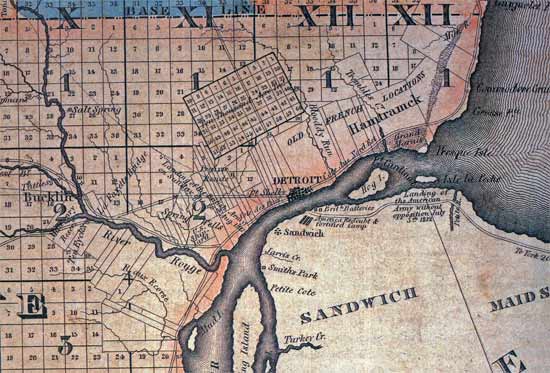
Detroit itself takes up only what is now the general downtown area. The area in the south is laid out on the original French ribbon farm pattern, oriented towards the river.
The big rectangle in the middle [[running roughly from today's Harper to Davison) is what was called the "Ten Thousand Acre Tract." This was land granted to Detroit by Congress to sell in lots in order to defray some of the costs associated with rebuilding Detroit after the fire of 1805. Parts of the City of Detroit and much of Hamtramck and Highland Park sit on this land today. As you can see, it is oriented to the city, the ribbon farms, the river, and Woodward Ave., in obvious contrast to the purely directional orientation of the surrounding areas.
The original 2007 thread on the 10,000 acre tract can be found here:
http://atdetroit.net/forum/messages/...tml?1173667967
And some more history on ribbon farms here:
http://atdetroit.net/forum/messages/...tml?1180288955Last edited by EastsideAl; April-05-12 at 05:02 PM.
-
April-05-12, 06:52 PM #15
DetroitYES Member
- Join Date
- Oct 2011
- Posts
- 120
The township boundry would have been at Dequnider, seperating Hamtramic Township from Greenfield Township. Originally Posted by Dexlin
BTW This map here is very intresting. Who knew Bell Isle was really part of Hamtramic?
http://www.davidrumsey.com/luna/serv...-Michigan--Dra
-
April-10-12, 03:05 AM #16
DetroitYES Member
- Join Date
- Sep 2011
- Posts
- 875
I'm still not getting it. John R isn't the only street that does this. Is John R equidistant between two important points, because if it's not, I'm not understanding why it switches from Woodward to John R. Originally Posted by gazhekwe
-
April-10-12, 11:34 AM #17
DetroitYES Member
- Join Date
- Apr 2009
- Posts
- 4,513
Since the entire street grid reorients to a true directional orientation north of Six Mile, I would guess that it just made sense to planners when the State Fair neighborhood was being laid out around 1920 to have the addressing dividing line run along a directionally true street as well.
Remember, this was at a time when there was a big effort to expand, modernize, and 'rationalize' the old City of Detroit and its streets [[which mirrored similar contemporary efforts in cities across the US) under mayors James Couzens and John Lodge. Reforms like the 1921 address changes were part of this effort. It seems likely then that planners at the time would have wanted the new land recently annexed north of Six Mile laid out in as 'rational' a fashion as possible too.
Mark Smiles is right above that, in light of the old township lines, it may have made more sense historically to have the dividing line run along Dequindre. But that would have created a big disjunctive jump in addresses, would have left a largish chunk of 'west side' confusingly directly north of the 'east side', and would have meant that several north-south streets would change from the east side to the west side at Six Mile.
But since John R is just one block east of Woodward at Six Mile, making John R the dividing line north of Six Mile effectively eliminated all of these problems, while still leaving the orientation directionally correct.Last edited by EastsideAl; April-10-12 at 12:19 PM.
-
April-10-12, 12:17 PM #18
DetroitYES Member
- Join Date
- Mar 2009
- Posts
- 2,160
I think Al hit on it in his last post: they needed to pick a north-south street in the grid pattern north of Highland Park [[which, by the way, only renumbered the north-south streets, and not the east-west streets), and John R was the closest major street to Woodward. Originally Posted by Dexlin
Just for reference, I tried to clean up my scan of the annexation of Detroit to show the city boundaries at the time of the renumbering:
-
April-11-12, 03:25 AM #19
DetroitYES Member
- Join Date
- Sep 2011
- Posts
- 875
Thanks, you two. Now that is something I can understand. I thought there was more method to the madness, but if they just arbitrarily chose John R. being the nearest major north-south street, that makes as good a sense as any.

 Reply With Quote
 Posting Permissions
Instagram
DetroitYES navigation
DetroitYES Management
© AtDetroit LLC 2000 - 2024 unless otherwise specified. Please notify us of uncited proprietary content.
Welcome to DetroitYES! Kindly Consider Turning Off Your Ad BlockingX
DetroitYES! is a free service that relies on revenue from ad display [regrettably] and donations. We notice that you are using an ad-blocking program that prevents us from earning revenue during your visit.
Ads are REMOVED for Members who donate to DetroitYES! [You must be logged in for ads to disappear]
Ads are REMOVED for Members who donate to DetroitYES! [You must be logged in for ads to disappear]
DONATE HERE »
And have Ads removed.
And have Ads removed.
Bookmarks