


Hi Everyone,
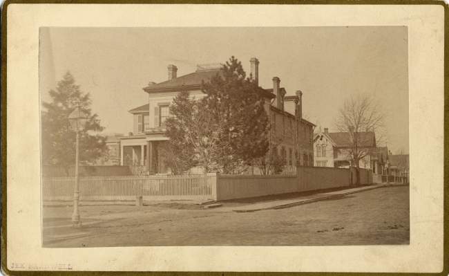
I need some help identifying the exact location of an address in the 1880's. My great-great-great grandfather, Ferdinand Reblin, is listed as a resident of 180 E. Elizabeth St., Detroit, MI, throughout the 1880's. I have not been able to locate a picture of that address or to determine exactly where his property was on the street, but I did find the attached image, which shows 187 E. Elizabeth in 1881. I'm wondering if anyone has information about the addressing system enough to tell me whether the house next door to the one featured in this image might be 180 E. Elizabeth - the home of my distant relative. Any help anyone could offer would be much obliged.
Thanks,
1953
Results 1 to 25 of 44
Thread: 180 E. Elizabeth in the 1880's
-
November-15-11, 09:08 AM #1
 DetroitYES Member
- Join Date
- Mar 2009
- Posts
- 1,106
 180 E. Elizabeth in the 1880's
-
November-15-11, 09:34 AM #2
DetroitYES Member
- Join Date
- Mar 2009
- Posts
- 5,840
180 E. Elizabeth appears to have changed to 564 in 1921. There was also a 180 1/2 that became 866 E. Elizabeth. I believe that it would have been between Beaubien and St. Antoine, which is under Ford Field. The house in the picture was changed to 583 E Elizabeth and would have been on the opposite side of the street
Last edited by jcole; November-15-11 at 09:36 AM.
-
November-15-11, 09:40 AM #3
DetroitYES Member
- Join Date
- Oct 2011
- Posts
- 43
-
November-15-11, 09:40 AM #4
DetroitYES Member
- Join Date
- Mar 2009
- Posts
- 1,106
Ah, the opposite side of the street! Curses! Thanks jcole for that wonderful assist. Much obliged!, as promised!
-
November-15-11, 09:43 AM #5
DetroitYES Member
- Join Date
- Mar 2009
- Posts
- 1,106
Thanks, too, Farwell; do you know why they did this renumbering project? Also, does anyone have pictures of this stretch of Elizabeth E. from the 1880s or later?
Thanks,
1953Last edited by 1953; November-15-11 at 09:52 AM.
-
November-15-11, 11:16 AM #6
DetroitYES Member
- Join Date
- Mar 2009
- Posts
- 2,162
Prior to renumbering, addresses were sequentially numbered without regard to distance or spacing of lots, homes, buildings, etc. The effect was to have an address on one street corner that differed by dozens or hundreds of numbers from an address on the corner of a parallel street at the same cross street. As the city grew the differences became greater the farther from the city center. Also, the numbering system left little room for new buildings built between existing buildings. The new numbering systems correlated the address number to the distance from the baseline [[Woodward/John R or Essex/Wabash RR). Originally Posted by 1953

-
November-15-11, 02:52 PM #7
DetroitYES Member
- Join Date
- Mar 2009
- Posts
- 1,106
Ah, very interesting. Thank you very much!
-
November-16-11, 09:07 AM #8
DetroitYES Member
- Join Date
- Dec 2010
- Posts
- 16
Have you ever checked Silas Farmer's History of Detroit. Its digitized on Google Books. There are several references to Elizabeth Street including the Beaubien Homestead at the corner NW corner of St. Antoine and Elizabeth; and the location of St. Matthew's Church on the SW corner of St. Antoine and Elizabeth. There is also a discussion about the Elizabeth Street Sunday School between Woodward and Park. On July 7 1860 a barn off Woodward between Elizabeth and Columbia burned down. Just a thought.
-
November-16-11, 11:03 AM #9
DetroitYES Member
- Join Date
- Mar 2009
- Posts
- 2,162
From what I can tell, it looks like 180 E. Elizabeth was at the corner of the alley that ran behind the west side of St. Antoine and was renumbered to 564-566. Across the alley to the east was the "colored" St Matthew's Episcopal Church, a picture of which is here:
http://quod.lib.umich.edu/d/dpa1ic/x...91/dpa2091.tif
The house to the right may have been 180 E Elizabeth.
Here are a few pictures of the street to the west to give you an idea of what it was like:
http://quod.lib.umich.edu/d/dpa1ic?r...et&select1=all
-
November-16-11, 11:51 AM #10
DetroitYES Member
- Join Date
- Mar 2009
- Posts
- 1,106
Zaddik: I have not checked Farmer's book yet, but will. Thanks for the tip.
MikeM: It took some serious mental energy, but I get what you're saying about the house being pictured to the right. Thanks for the map, too.
I see on the map that there is a home for aged "colored people" and the "colored" Episcopal Church - my relatives were German immigrants from the 1850's; I find it interesting that they lived in such a "colored" neighborhood. That said, any idea if this truly was a "colored" neighborhood of if it was mixed?
-
November-16-11, 12:03 PM #11
DetroitYES Member
- Join Date
- Mar 2009
- Posts
- 2,162
Well, the map is from 1921. The picture of the church is from 1883.
-
November-16-11, 12:16 PM #12
DetroitYES Member
- Join Date
- Mar 2009
- Posts
- 5,840
The footprint of the church on the map is significantly larger than the picture of the church. I'd guess that it was either torn down and rebuilt or added on to by quite a bit. The homes by the church were probably torn down for expansion.
-
November-16-11, 01:06 PM #13
DetroitYES Member
- Join Date
- Mar 2009
- Posts
- 1,106
Was there still a St. Mathew's church on this site when demolition began for the stadiums? If so, anyone have any pictures?
-
November-16-11, 02:02 PM #14
DetroitYES Member
- Join Date
- Apr 2009
- Posts
- 5,875
Wasn't this the old Cathedral that was in Brush Park? If I am rembering correctly this would be the site of the crosswinds condos. There was no church on the site prior to demo for the stadii. Originally Posted by 1953
Last edited by DetroitPlanner; November-16-11 at 02:04 PM.
-
November-16-11, 02:27 PM #15
DetroitYES Member
- Join Date
- Mar 2009
- Posts
- 3,989
DP- I believe you're thinking of the one-time Detroiter Hotel or Savoy or LaSalle that became a convent of sorts for Carmel Light [[?) nuns. That was the hotel where the gangster gunned down that radio host in '29 the night Mayor Bowels was recalled.
ah ... here's a link from our friend BoD
http://historicdetroit.org/building/hotel-detroiter/
And 1953... I would think that entire block of Elizabeth was removed when Hudson's built their warehouse there.
-
November-16-11, 02:37 PM #16
DetroitYES Member
- Join Date
- Mar 2009
- Posts
- 1,106
Looking at a map of the stadium area today, it doesn't appear that the warehouse portion crosses Elizabeth, though I could be wrong. I suppose there might have been other buildings that took out Elizabeth over the years, but someone should know the answer to that question...someone older than I: did Elizabeth make it to Gratiot anytime in recent memory?
-
November-16-11, 05:36 PM #17
DetroitYES Member
- Join Date
- Mar 2009
- Posts
- 2,162
Looks like the house across the street that you posted a picture of [[187 E Elizabeth) eventually became the Florence Crittenton Home for Women & Children. [[The alley between the church and your g-g-g-grandfather's home didn't continue north beyond Elizabeth.)
E. Elizabeth ended at the alley along the north side of Gratiot, in the middle of the Stroh Brewery complex.Last edited by MikeM; November-16-11 at 05:48 PM.
-
November-16-11, 06:39 PM #18
DetroitYES Member
- Join Date
- Apr 2009
- Posts
- 4,513
Elizabeth did not go through to Gratiot at any time in my living memory. It was cut off, along with all other nearby streets, when construction of the Chrysler Fwy. was begun up Hastings St. in 1959. It ended at St. Antoine after that. My memory of that area is mostly from the '70s when there were just a few scattered old houses left, amid small businesses and empty lots. The Hudsons warehouse was a block south between Adams and Beacon.
I believe the "cathedral" that previous poster was talking about was old St. Patrick's, which was on Adelaide near John R. It was renamed as Sts. Peter and Paul for many years [[like the old church on Jefferson) and served as Detroit's Roman Catholic cathedral for over 40 years before the building of Blessed Sacrament in the 1930s. After St. Patrick's moved across Woodward in the early '70s to its current location on Parsons St., that old church sat hulking and abandoned for several years before it was finally torn down.
St. Matthew's Episcopal, seen on the map that MikeM posted, was actually a very important church in the history of Detroit's African American community. It was founded in the 1840s as Detroit's third African American church [[after Second Baptist and Bethel AME) by people who were involved in the Underground Railroad. The church at St. Antoine & Elizabeth was built in the 1883, so right around the time the picture MikeM posted was taken. [[Interestingly, their previous building was sold to Congregation Shaarey Zedek, which would become, and remains, one of the most important religious institutions in Detroit's Jewish community). The Detroit chapter of the NAACP was founded at organized at St. Matthew's. It shows up on p591 of Farmer's history.
Back then Germans dominated that part of the east side, from Broadway on out, along with Italians and others. The city's black population was quite small and was interspersed with European immigrants. As the black population grew in the 20th century though, particularly after the explosion of the auto industry, those neighborhoods - Black Bottom south of Gratiot, and then Paradise Valley to the north - increasingly became the center of a larger and more homogeneous African-American community. The area around that church became a kind of institutional center for the black community from the 1920s or so on, with several other important churches nearby, the "colored" YMCA and YWCA [[which replaced the Crittenton Home across the street in 1932 when it moved up onto Woodrow Wilson) within a block, the Michigan Chronicle newspaper, and some of Detroit's earliest black hospitals and health facilities [[like the Wheatley home)
In 1971, after the freeways and urban renewal had pretty much entirely destroyed that neighborhood, St. Matthew's merged with another church and moved to their building on Woodward near Holbrook, to form the still-existing St. Matthew's-St. Joseph's Episcopal Church. The building on St. Antoine stood empty thereafter into the 1980s, if memory serves me. But I'm not sure if it was still there by the time the land was cleared for Ford Field.
If your ancestors were German there is still one part of that once-flourishing German neighborhood operating not too far away. The beautiful St. Joseph's Roman Catholic church at the corner of Orleans and Jay was built by the German community in 1870 [[the congregation dates to 1855) and is still going today. You may want to talk to them if you are in search of some ancestors who may appear in local parish records.Last edited by EastsideAl; November-16-11 at 07:12 PM.
-
November-16-11, 07:27 PM #19
DetroitYES Member
- Join Date
- Mar 2009
- Posts
- 2,060
Thank you SO much for this thread! I am downloading the Silas Farmer book right now -- I'm just reading the preface, and I'm getting teary-eyed and sentimental. So much history separates us, and yet, he loved this city as we do. May future generations love her, too.
-
November-16-11, 07:53 PM #20
DetroitYES Member
- Join Date
- Apr 2009
- Posts
- 4,513
Interestingly, it looks as if that house may have been there as late as 1981. Below is a picture taken from the DTE aerial photos from 1981. The view is looking at St. Antoine and Elizabeth with the Hudson's warehouse towards the south at the bottom and what had been the colored [[Lucy Thurman branch) YWCA to the north towards the top. You can see the old St. Matthew's Church on the southwest corner, and just behind it, under some overgrowth, something that sure looks like a house.
Alas, it is gone by the time of the next, and last, DTE pictures of 1997. The old church is still there, and the Y, but the house is gone. Soon thereafter, of course, it would all be gone anyway for Ford Field.
-
November-16-11, 09:19 PM #21
DetroitYES Member
- Join Date
- Apr 2009
- Posts
- 4,513
This page contains, I believe, a [[pretty bad) picture of the house in question circa 1976:
http://www.placepromo.com/display.ph...y+-+MI&page=91
With the primitive tools at my disposal I tried to make it a bit larger and brighter so the house can be seen better:
-
November-16-11, 09:42 PM #22
DetroitYES Member
- Join Date
- Mar 2009
- Posts
- 2,162
Here you go:
-
November-16-11, 09:43 PM #23
DetroitYES Member
- Join Date
- Mar 2009
- Posts
- 2,162
Oops, Al beat me to it.
-
November-16-11, 09:47 PM #24
DetroitYES Member
- Join Date
- Mar 2009
- Posts
- 2,162
And the church with the house in the background:
-
November-16-11, 10:49 PM #25
DetroitYES Member
- Join Date
- Mar 2009
- Posts
- 1,106
Honestly, I am blown away. Thank you all so much for your efforts! Somehow, from the annals of history, you seem to have found a picture of my great-great-great grandfathers house, still standing in the year I was born! Amazing! My family will be thrilled by this development, when I share it with them! I am so glad that I posted my inquiry and so thankful that you all were able to assist. Please let me know if there is ever anything I can do in return!

 Reply With Quote
 Posting Permissions
Instagram
DetroitYES navigation
DetroitYES Management
© AtDetroit LLC 2000 - 2024 unless otherwise specified. Please notify us of uncited proprietary content.
Welcome to DetroitYES! Kindly Consider Turning Off Your Ad BlockingX
DetroitYES! is a free service that relies on revenue from ad display [regrettably] and donations. We notice that you are using an ad-blocking program that prevents us from earning revenue during your visit.
Ads are REMOVED for Members who donate to DetroitYES! [You must be logged in for ads to disappear]
Ads are REMOVED for Members who donate to DetroitYES! [You must be logged in for ads to disappear]
DONATE HERE »
And have Ads removed.
And have Ads removed.
Bookmarks