


More great shots from Shorpy!
Woodward Shorpy called this the "soap & theater district" Was it really called that? lol
http://www.shorpy.com/node/11489?size=_original
Livingstone Channel http://www.shorpy.com/node/11478?size=_original
Results 1 to 25 of 37
-
October-23-11, 06:27 PM #1
 DetroitYES Member
- Join Date
- Jun 2010
- Posts
- 571
 Shorpy Two'fer - Woodward 1905 & Livigstone Channel construction 1910
-
October-23-11, 07:08 PM #2
 DetroitYES Member
- Join Date
- Mar 2009
- Posts
- 9,406
Thanks for the post! Had to do some checking... not familar with all the Channel names in the Detroit River... the Livingston Channel is west of Bob-lo Island [[Bois Blanc). I was thinking that since the Livingston Lighthouse is at the eastern tip of Belle Isle, that the Livingston channel was over there... not so... the shipping channel between Belle Isle and Canada is the Fleming Channel. While the channel to the north of Belle Isle... I can't seem to find a name for it... only that it's 2 channels separated by the 1 to 6 ft. deep Scott Middle Ground... probably the shallowest point in the Detroit River basin [[aside from the riverbanks). Interestingly enough the 2 channels to the north and south of Scott Middle Ground are each 19-30 ft. deep.
-
October-23-11, 07:09 PM #3
DetroitYES Member
- Join Date
- Mar 2009
- Posts
- 67
Socialist....something..... Reading room? Ha! lol.
-
October-23-11, 07:26 PM #4
DetroitYES Member
- Join Date
- Mar 2009
- Posts
- 8,166
I noticed that too. Quick! Call the tea party! LOL! Originally Posted by Redleg81

-
October-23-11, 08:09 PM #5
DetroitYES Member
- Join Date
- Jun 2010
- Posts
- 571
I always find it interesting that they could wall off a whole section of the river like that and pump it dry to do this work back then. I can't quite decide what shoreline we're looking at n the background though. I'm leaning toward Amherstburg, at the north end of the channel because of how close it is...and the island that forms Crystal Bay would not have been around back then, since IIRC it's only made of the excavated materials from the channel itself. I see power lines on the shore, which I'll assume are from the SW&A streetcar lines. I think the line reach A'Burg by then........ Originally Posted by Gistok
-
October-23-11, 09:13 PM #6
DetroitYES Member
- Join Date
- Oct 2011
- Posts
- 4
I agree with you, Magnatomicflux, to see them pull off an undertaking like that is truly amazing, given the logistical and technological limitations that they faced. I believe that is the Amherstburg shoreline as well...
The Shorpy photo that we posted yesterday also featured Detroit's riverfront in the 1900s. We're not sure where it was taken; can anyone identify the location of this photo?
http://woodwardspine.com/2011/10/22/...y-onward-1908/
-
October-23-11, 09:23 PM #7
DetroitYES Member
- Join Date
- Apr 2009
- Posts
- 5,875
I too agree. I had always assumed that the sides of the Livingstone channel came from dredging. I can recall being in it once when I took the Boblo Boat from the Gibraltar dock. It had to be 1985 or 1986. Originally Posted by mfossano
-
October-23-11, 10:04 PM #8
DetroitYES Member
- Join Date
- Mar 2009
- Posts
- 2,160
Belle Isle. I think I see the waterworks in the far right. Originally Posted by mfossano
-
October-23-11, 10:23 PM #9
DetroitYES Member
- Join Date
- Mar 2009
- Posts
- 1,370
Based on the wrought iron detailing on the side of the bridge in the background, it has to be on Belle Isle. Originally Posted by mfossano
-
October-24-11, 04:58 AM #10
DetroitYES Member
- Join Date
- Mar 2009
- Posts
- 3,989
On Belle Isle just after exiting the bridge. Looks like a Buick

-
October-24-11, 05:12 AM #11
DetroitYES Member
- Join Date
- Mar 2009
- Posts
- 3,989
I'm not feeling the 1905 date on this pic. Not a single car in sight? Not one? I know it's early in the auto boom days, but I'm pretty sure there should be a car or two in the pic if the date was 1905. I'm thinking late 90's.
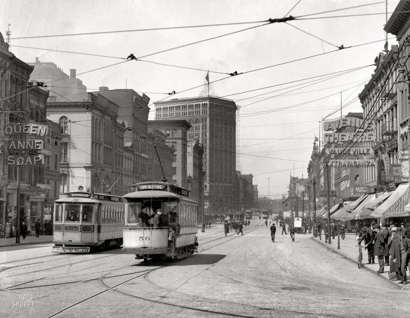
-
October-24-11, 12:57 PM #12
DetroitYES Member
- Join Date
- Apr 2009
- Posts
- 278
The clothing looks more like 1905 than the 1890s. But you are right-- there's not a single automobile that I can see. It is interesting that there are so few women in the photo, too. In plenty of other shots, there are many women walking on the street. Perhaps the kind of business at this end of Woodward didn't involve many women, or maybe it had more to do with the time of day. I have a photo from this era taken a block farther south, and there were women in the shot.
-
October-24-11, 01:28 PM #13
DetroitYES Member
- Join Date
- Mar 2009
- Posts
- 3,989
Here is another Shorpy pic labeled 1905, I'm seeing at least 4 autos, ...
large view
http://www.shorpy.com/node/7658?size=_original
-
October-24-11, 03:12 PM #14
DetroitYES Member
- Join Date
- Jun 2010
- Posts
- 571
I agree gnome. I didn't even notice the lack of cars! Gotta be the end of the century.
-
October-24-11, 04:44 PM #15
DetroitYES Member
- Join Date
- Mar 2009
- Posts
- 1,370
The day that photo appeared on Shorpy, I did some browsing in the 1905 Detroit Polk directory and found many of those business shown on Woodward in the first two blocks north of Jefferson, including Swan's Restaurant on the NW corner at Larned. That said, it could still have been taken earlier, but it would take considerable time for me to review earlier Directories to see when all of the easily identifiable businesses first show up together. Originally Posted by gnome
-
October-24-11, 05:13 PM #16
DetroitYES Member
- Join Date
- Jan 2010
- Posts
- 645
[QUOTE=gnome;279760]On Belle Isle just after exiting the bridge. Looks like a Buick QUOTE]
No it is not a Buick.
I placed the comment on the Shorpy website under my name there DrDetroit
The car is a 1906 Packard Runabout, model S [[24)
The Packard Plant was only 3 miles from Belle Isle and they frequently used Belle Isle to road test cars.
Question now: Who is the driver??
-
October-24-11, 05:14 PM #17
DetroitYES Member
- Join Date
- Jun 2010
- Posts
- 571
Originally Posted by Mikeg
 ......Soooooooo.....are you gonna get started on that?
 ")


j/k lol
-
October-24-11, 05:39 PM #18
DetroitYES Member
- Join Date
- Jun 2010
- Posts
- 571
[QUOTE=Packman41;279925Question now: Who is the driver??[/QUOTE]
Walter Briggs???
I don't know lol...just a guess!
-
October-24-11, 05:46 PM #19
DetroitYES Member
- Join Date
- Mar 2009
- Posts
- 1,370
Maybe....... Originally Posted by Magnatomicflux
I'll need a full morning with nothing on my calendar, much like the day when I did some NYC Directory sleuthing on this Shorpy photo [[look for the comment "Turnout on W. 36th St.?")
-
October-24-11, 06:03 PM #20
DetroitYES Member
- Join Date
- Oct 2011
- Posts
- 5
That could be my grandfather operating the steam shovel. Just wishful thinking. In the 1910 census he is listed as a riverman, dredge operator. From family history I know that he worked on the Livingston channel. However, in the twenties he was employed by the Solvay Process Co. as a steam shovel operator, a skill that required a license, which was probably learned while working on the Livingston Channel. .
.
-
October-24-11, 06:04 PM #21
DetroitYES Member
- Join Date
- Jun 2010
- Posts
- 571
Wow...good work on that! If you do find the time, I'm very interested in the results now that it's a bit of a mystery! Originally Posted by Mikeg
Last edited by Magnatomicflux; October-24-11 at 06:10 PM.
-
October-24-11, 07:35 PM #22
DetroitYES Member
- Join Date
- Mar 2009
- Posts
- 1,470
Not a geology expert by any means but there is that much rock in such a shallow sprt of the river?
-
October-24-11, 07:38 PM #23
DetroitYES Member
- Join Date
- Mar 2009
- Posts
- 3,989
Good work everyone, thanx Packman for that correction, I didn't see your post in Shorpy until after I posted my comment.
The question on who might be driving that Packard is interesting. The fellow looks a little long in the tooth to be Walter O Briggs in 1908. He was born in 1877, in ypsi, so he was barely 30 at the time the pic was taken. But M-Flux, you might be on the right track with someone who was an exec at Packard.
The gentleman looks rather prosperous and because the wheels are just slightly blurred indicates he was driving at a very sloooow speed. The wheels are no more blurred than the lady in the background, so I'm guessing Mr. Exec was going only 5 or 10 mph. Certainly not a breakneck pace one would surmise if the guy was going on a shakedown test track run.
-
October-24-11, 09:26 PM #24
DetroitYES Member
- Join Date
- Jun 2010
- Posts
- 571
See I was kinda wondering that too. But the Tashmoo ended her life striking submerged rocks after leaving Sugar Island. Originally Posted by Patrick
gnome - I wonder if he's only going slow at the moment because he's checking something out. He seems to be looking at something on the "dash" area. What would have been displayed in that spot back then I know not. Or maybe he's listening to a sound.
Maybe it just wasn't polite to rip past women with a noisey, dust throwin' machine of the future.
maybe someone just yelled "GET A HORSE!!!" and he felt bad about it.
-
October-24-11, 11:55 PM #25
DetroitYES Member
- Join Date
- Mar 2009
- Posts
- 9,406
Patrick... read this Army Corp. of Engineers paper.... the 3rd paragraph talks about how the lower river [[near the islands) has a lot of rocks and boulders... Originally Posted by Patrick
http://www.lre.usace.army.mil/greatl...detroit_river/

 Reply With Quote
 Posting Permissions
Instagram
DetroitYES navigation
DetroitYES Management
© AtDetroit LLC 2000 - 2024 unless otherwise specified. Please notify us of uncited proprietary content.
Welcome to DetroitYES! Kindly Consider Turning Off Your Ad BlockingX
DetroitYES! is a free service that relies on revenue from ad display [regrettably] and donations. We notice that you are using an ad-blocking program that prevents us from earning revenue during your visit.
Ads are REMOVED for Members who donate to DetroitYES! [You must be logged in for ads to disappear]
Ads are REMOVED for Members who donate to DetroitYES! [You must be logged in for ads to disappear]
DONATE HERE »
And have Ads removed.
And have Ads removed.
Bookmarks