


Great human interest photo. Belle Isle supposedly circa 1907
http://www.shorpy.com/node/11443?size=_original
Results 1 to 24 of 24
-
October-12-11, 06:49 PM #1
 DetroitYES Member
- Join Date
- Apr 2010
- Posts
- 1,181
 Shorpy's Strikes again... [Belle Isle supposedly circa 1907]
-
October-12-11, 07:38 PM #2
DetroitYES Member
- Join Date
- Mar 2009
- Posts
- 8,173
There was a similar Shorpy photo posted here before but I think this one's different. I love the Victrola in the foreground.
-
October-12-11, 08:25 PM #3
DetroitYES Member
- Join Date
- Apr 2010
- Posts
- 1,181
I think that boy was having flights of fancy.

-
October-12-11, 08:31 PM #4
DetroitYES Member
- Join Date
- Jun 2010
- Posts
- 156
Too bad they didn't have the internet back then.
People could post complaints about the cruising.
-
October-13-11, 12:32 AM #5
DetroitYES Member
- Join Date
- Apr 2009
- Posts
- 489
I hope this dude's girlfriend left him.
-
October-13-11, 07:08 AM #6
DetroitYES Member
- Join Date
- Feb 2010
- Posts
- 3,901
LOL! I noticed that too! Perhaps she was bulking up in preparation for child bearing? Originally Posted by Pcm

-
October-13-11, 07:31 AM #7
DetroitYES Member
- Join Date
- Mar 2009
- Posts
- 1,370
I think she did. He was terribly moody and kept mumbling something about needing to get into character. Originally Posted by Pcm
-
October-13-11, 02:30 PM #8
DetroitYES Member
- Join Date
- Oct 2009
- Posts
- 1,557
Originally Posted by Jimaz
I was having the same thoughts, could even be the same picture.
-
October-14-11, 08:16 AM #9
DetroitYES Member
- Join Date
- Apr 2009
- Posts
- 197
I'm loving that the guy in the foreground brought his own tunes! Guess he didn't hear that boom boxes were banned on Belle Isle.
-
October-14-11, 10:51 AM #10
DetroitYES Member
- Join Date
- Jul 2011
- Posts
- 1,325
What would be the chances of multiple photographs from the same event over 100 years ago?
http://dlxs.lib.wayne.edu/cgi/i/imag...art=;resnum=86
http://dlxs.lib.wayne.edu/cgi/i/imag...art=;resnum=90
I've been trying to figure out where exactly this image is taken from...and it turns out neither bridge [[the one in the foreground and in the background) exist anymore [[that is, if these pictures are facing south). The bridge that exists now closest to the casino was built around the first Grand Prix races on Belle Isle, and the farther bridge was built recently in 2007-2009.
http://g.co/maps/vrgqq
It looks as though the Band Stand, the main bridge in the photographs, was demolished sometime before 1949. It's pictured in the below aerial [[1940) but it's not on the DTE aerial archives [[1949).
http://dlxs.lib.wayne.edu/cgi/i/imag...rt=;resnum=115
It looks like it was a popular scene since there are permanent benches and a few postcards of the spot.
http://dlxs.lib.wayne.edu/cgi/i/imag...rt=;resnum=196
http://www.loc.gov/pictures/resource/det.4a10930/
http://www.ebay.com/itm/MICHIGAN-DET...#ht_1046wt_825
http://www.cardcow.com/170701/lagoon...roit-michigan/
http://www.cardcow.com/331744/canoes...roit-michigan/
People would get their canoes from up the canal.
http://g.co/maps/5mht2
Evidenced by attractive lady and Detroit skyline in the background.
http://dlxs.lib.wayne.edu/cgi/i/imag...rt=;resnum=282
That building was then demolished and replaced in the 1960s [[looks like a boat holding place or something, can't tell on aerial pictures) only to be demolished in 2005-6.
Sorry, I went into a curious mystery and learned a whole lot. Forgive me if this was known already.
Last edited by animatedmartian; October-14-11 at 10:56 AM.
-
October-14-11, 11:25 AM #11
DetroitYES Member
- Join Date
- Mar 2009
- Posts
- 3,864
Good research, maritian. Isn't it amazing how some item you note on the internet whets your curiosity and gets you digging into the 'net for more info?
-
October-14-11, 11:52 AM #12
DetroitYES Member
- Join Date
- Jul 2011
- Posts
- 1,325
I think it's even more amazing how much history some locales have. And also how much of it is preserved through photographs since quite a lot has been demolished and changed. How awesome would it be if canoeing made a come back on Belle Isle? Or at the very least having that grandeur it had during the first half of the century. Ah, imagination is running away...
-
October-14-11, 12:02 PM #13
DetroitYES Member
- Join Date
- Mar 2009
- Posts
- 3,989
I agree with Ray, AM, great work.
-
October-14-11, 02:12 PM #14
DetroitYES Member
- Join Date
- Apr 2009
- Posts
- 4,513
Here is the earlier Shorpy picture of the same scene:
http://www.shorpy.com/node/9167?size=_original
I like this picture because it shows a group of guys in the foreground who I believe are from the then-new Eastern High School [[note the "EHS" pillow on one of the boats, and the other boats with Indian-themed pillows). My paternal grandparents met as Eastern High students in the early '20s, and my grandfather played on the 1922 Eastern Indians city championship football team.
Also, you can see a great lineup of early autos parked off to the right.
Thanks for your detective work animatedmartian. I particularly like the shot of the old boat rental building. I am just old enough to have rented canoes from both it and its successor building.Last edited by EastsideAl; October-14-11 at 04:05 PM.
-
October-14-11, 02:24 PM #15
DetroitYES Member
- Join Date
- Mar 2009
- Posts
- 891
Very nice, AM. I particularly liked the shot of the very attractive lady.

-
October-14-11, 02:46 PM #16
DetroitYES Member
- Join Date
- Apr 2009
- Posts
- 4,513
The view in this picture is indeed looking south down the canal from just to the east of the Casino. The bandstand bridge was just to the south of where the more northern of the 2 footpath bridges that animatedmartian mentions is today. The bridge in the background of this picture is the Casino Way/Muse Rd. Bridge that was demolished sometime in the 1980s or early 90s. The railings from that bridge, complete with 2 plaques in the center that are also visible in this Shorpy picture, have been reused on the footbridge that replaced it, which is the southerly one of the footbridges that cross the canal there now. I believe that this picture was taken from the still-extant [[though heavily reconstructed) Central Ave. bridge
More on the footbridge and the preserved railing:
http://www.historicbridges.org/beam/...ino/photos.htm
The earlier Shorpy canal picture I linked to above faces the opposite direction, up the canal towards the Central Ave. Bridge. I think it was taken from the Casino bridge shown in the background here. In a thread on this board about that earlier picture, Stosh posted a wintertime picture of the area that makes the location a bit clearer. In this picture a structure with a distinctive roofline can be seen in the deep background behind the bandstand. This is a picnic shelter that is still standing today just to the east of the canal and the northeast of the Central Ave. bridge.

This post has been heavily edited by me upon a reconsideration of the original photo, which revealed a terrible error of orientation on my part.
Last edited by EastsideAl; October-14-11 at 05:09 PM.
-
October-14-11, 03:01 PM #17
DetroitYES Member
- Join Date
- Mar 2009
- Posts
- 1,370
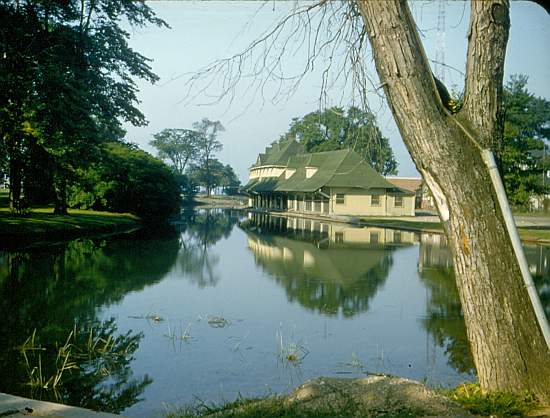
The canoe rental building on Belle Isle [[minus the pretty girl), taken on Sept. 5, 1956.
[[full size)
-
October-14-11, 04:02 PM #18
DetroitYES Member
- Join Date
- Apr 2009
- Posts
- 4,513
OK, now I'm really beating this horse to death [[hey, it's a slow Friday, no Tigers game, etc...) but here is a photo that makes the geography of the whole area clear. This is from 1931 and I'm pretty certain from the orientation of the street and the canal [[which remains the same today) that this is looking north with the Casino just out of view to the lower left. The now-gone Casino Way/Muse bridge is in the foreground [[note that the railings and plaques match those preserved on the present-day footbridge), then looking up the canal comes the bandstand bridge, and then the still-extant [[though widened in 1947 and reconstructed in 2009) Central Ave. bridge.

The seats along the bank are still there, as they also appear to be in the 1940 aerial shot that animatedmartian linked above - I wonder if they were still having concerts there by that time?
-
October-14-11, 04:59 PM #19
DetroitYES Member
- Join Date
- Apr 2009
- Posts
- 4,513
Same area today:
-
October-14-11, 06:17 PM #20
DetroitYES Member
- Join Date
- Mar 2009
- Posts
- 8,173
The similar photo was in this year-old thread. Originally Posted by Jimaz
-
October-14-11, 06:21 PM #21
DetroitYES Member
- Join Date
- Jul 2011
- Posts
- 1,325
Nice work EastsideAl. Guess we're all learning a little history lesson today.
-
October-14-11, 06:40 PM #22
DetroitYES Member
- Join Date
- Mar 2009
- Posts
- 140
Shorpy's? Wow, you really are from Michigan!
-
October-14-11, 06:51 PM #23
DetroitYES Member
- Join Date
- Dec 2010
- Posts
- 101
Originally Posted by Mikeg
This other guy on the left was already in character, and his neighbors are clearly not too pleased.
-
October-14-11, 07:03 PM #24
DetroitYES Member
- Join Date
- Jul 2010
- Posts
- 126
What of the red Casino way bridge? Originally Posted by animatedmartian
The plaque on it claims it was built in 1893 by the King Bridge Co., Cleveland OH.
Is this one of the bridges in the photos?

 Reply With Quote
 Posting Permissions
Instagram
DetroitYES navigation
DetroitYES Management
© AtDetroit LLC 2000 - 2024 unless otherwise specified. Please notify us of uncited proprietary content.
Welcome to DetroitYES! Kindly Consider Turning Off Your Ad BlockingX
DetroitYES! is a free service that relies on revenue from ad display [regrettably] and donations. We notice that you are using an ad-blocking program that prevents us from earning revenue during your visit.
Ads are REMOVED for Members who donate to DetroitYES! [You must be logged in for ads to disappear]
Ads are REMOVED for Members who donate to DetroitYES! [You must be logged in for ads to disappear]
DONATE HERE »
And have Ads removed.
And have Ads removed.
Bookmarks