


This was a 1947 map published by R. L. Polk, the directory publisher. I can't remember where I bought it; eBay or an antique store or a used book store. I suspect it was ripped off the inside cover of a city directory. I have it scanned into nine sections. I highlighted most of the industries but missed a few, and I no longer have the original scans without the highlighting, but I still have the original map.
Compared to most maps, it's difficult to read since it doesn't differentiate the the street types - a major street like Woodward is depicted the same as a short residential cul-de-sac. It does label a several of the major factories around town - more than most. Some have the building layout depicted like above, while others are just blank spots with the company name. I have some gas station maps from the 1950s which show the major factories, but not as many as this one. Search eBay and other online sites, or antique stores and used book stores for vintage maps from the era; some are more detailed than others.
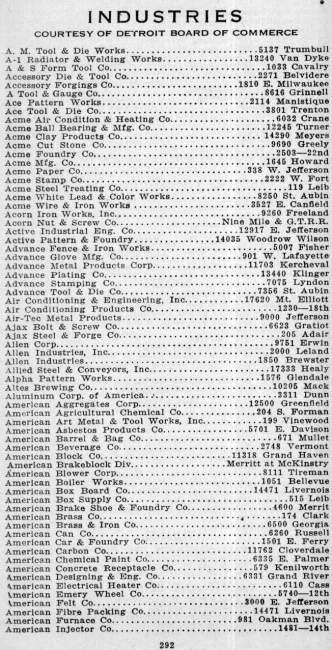
I have a 1943 directory that has a list of significant industries in the city. Some day I might try to map them out either with Google Maps or GIS software. There were a few different directory or street guide publishers such as Federal and Polk and Sauer that made directories like this:
Results 1 to 5 of 5
Hybrid View
-
December-24-12, 06:08 PM #1
 DetroitYES Member
- Join Date
- Mar 2009
- Posts
- 2,166

-
December-24-12, 09:59 PM #2
DetroitYES Member
- Join Date
- Jan 2012
- Posts
- 14
Thanks, MikeM
MikeM, Originally Posted by MikeM

It would be hard to imagine a quicker or more pertinent reply! I recently acquired a 1953-4 Polk Directory, but no luck on a map like this. You still have the scans--any chance I could get them? What I'd propose to do is to stitch them together into one using Photoshop, very possibly writing as a losslessTIF file, though big. What I'd then do to repay the community is to upload it to one of the free upload/download sites such as Rapidshare. That way anyone who wanted it could download a high quality copy.
I also don't recall seeing in my 1953-4 Polk a listing of manufacturers such as you found in the earlier one. If it's not too much of a pain to scan [[well, somewhat of a pain), I'd really encourage you to post to the forum.
Thanks, again, MikeM. Looks like Santa found some time tonight to come through.

 Reply With Quote
 Posting Permissions
Instagram
DetroitYES navigation
DetroitYES Management
© AtDetroit LLC 2000 - 2024 unless otherwise specified. Please notify us of uncited proprietary content.
Welcome to DetroitYES! Kindly Consider Turning Off Your Ad BlockingX
DetroitYES! is a free service that relies on revenue from ad display [regrettably] and donations. We notice that you are using an ad-blocking program that prevents us from earning revenue during your visit.
Ads are REMOVED for Members who donate to DetroitYES! [You must be logged in for ads to disappear]
Ads are REMOVED for Members who donate to DetroitYES! [You must be logged in for ads to disappear]
DONATE HERE »
And have Ads removed.
And have Ads removed.
Bookmarks