


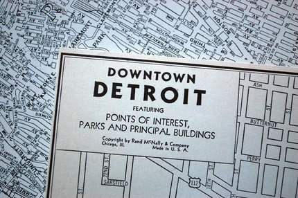
I would like to know if anyone has come across the Detroit map [[below) online and if so could you provide the source. Ideally, I am wondering if it is available somewhere as a .tiff, .jpg, or .pdf download. I don't know the date but it's certainly early to mid 20th century [[closer to the latter).
Attachment 5442
Attachment 5443
Results 1 to 25 of 34
Thread: Historic Maps of Detroit
-
March-09-10, 08:36 PM #1
 DetroitYES Member
- Join Date
- Mar 2010
- Posts
- 10
 Historic Maps of Detroit
-
March-09-10, 09:10 PM #2
DetroitYES Member
- Join Date
- Mar 2009
- Posts
- 77
You have to go to Sanborn maps. Maybe your local library will have access to the site.
http://sanborn.umi.com/
-
March-09-10, 10:02 PM #3
DetroitYES Member
- Join Date
- Mar 2010
- Posts
- 10
This does not appear to be a technical/commercial map but a tourist map.
-
March-09-10, 10:11 PM #4
DetroitYES Member
- Join Date
- Mar 2009
- Posts
- 3,989
I believe it is from 1934-36, the old post office is still standing. This is the map that our own AndyLynn uses to create his unique art/craft objects. You could ask him. Or if you are hoping to lay your hands on his secrect ingrediant, ...good luck with that plan.
-
March-09-10, 10:42 PM #5
DetroitYES Member
- Join Date
- Mar 2010
- Posts
- 10
Nope, want to use it as a reversed outline graphic background.
-
March-10-10, 07:41 AM #6LodgeDodger Guest
I have a city streeet map book that is very similar to the map shown. I'll have to look for the publisher's name.
-
March-10-10, 08:56 AM #7
DetroitYES Member
- Join Date
- Apr 2009
- Posts
- 835
"This does not appear to be a technical/commercial map but a tourist map."
I concur with the above poster that this looks just like a Sanborn. DPL has on-site only access to them. Some universities offer Sanborn electronic access to their students through their libraries as well.
I should add that I believe that Sanborn maps are copyrighted; however, I don't know for sure.
-
March-10-10, 09:26 AM #8Stosh Guest
It's not a Sanborn map. The numbers on the map reference individual buildings, not larger zones.
 Originally Posted by Baselinepunk

-
March-10-10, 09:43 AM #9
DetroitYES Member
- Join Date
- Apr 2009
- Posts
- 835
"It's not a Sanborn map. The numbers on the map reference individual buildings, not larger zones."
From the pictures provided, it's hard to tell; however, after looking a little closer at it, I think that you may be right that it looks like some sort of destination map. I used to use one similar to that in a former position I had to get around the city proper way back in the day. Perhaps contacting the city planning department? [[ I know, but just don't laugh too hard ). I may have a copy of it buried deep in the home archives.
-
March-10-10, 10:01 AM #10
DetroitYES
- Join Date
- Feb 2009
- Posts
- 6,778
That looks similar to an early 40's map of Detroit that I have. Somewhere on the old forum I posted a few scans of the downtown district from the reverse side, which show names all the major businesses.
-
March-11-10, 06:19 PM #11
DetroitYES Member
- Join Date
- Mar 2010
- Posts
- 10
Lowell,
Now that you mention it, I do have a tri-fold street map from the early 80s that is pretty much identical [[although it has street directional arrows and more building detail). I remember getting it through the Detroit Visitors Bureau back then. It says "Drawn by AAA Michigan" and "Copyright by Automobile Club of Michigan."
The front features drawings of the RenCen, Noguchi fountain, trolley, Spirit of Detroit, obelisk at Hart Plaza and the shoreline. It is called "Detroit Visitors Map." The reverse side listed points of interest [[a population of 1,302,300) and an index to all the numbered buildings [[1-117). Silver's Office Supply is listed at the former State Savings Bank building. Silver's opened there in 1980.
If anyone knows how to find/view/obtain any of their [[AAA) old maps digitally, please post.
-
March-11-10, 10:42 PM #12
DetroitYES Member
- Join Date
- Mar 2009
- Posts
- 1,370
-
April-05-10, 08:45 PM #13
DetroitYES Member
- Join Date
- Apr 2009
- Posts
- 392
Found the map
http://www.etsy.com/view_listing.php...age=6&includes[]=tags
Found the exact map. But I feel obligated exactly what Gnome already did: This image is being used by Andy Linn, and I would caution against any commercial duplication. Which will only result in the entire city, myself included, being ticked off at you.
-
April-05-10, 09:54 PM #14Stosh Guest
That's so funny it's really not funny.. Originally Posted by REL
I wonder if Rand McNally ever renewed their copyright?
http://onlinebooks.library.upenn.edu...1964JanJun.pdfLast edited by Stosh; April-05-10 at 10:13 PM.
-
April-06-10, 11:43 AM #15
DetroitYES Member
- Join Date
- Mar 2009
- Posts
- 277
Kbreenbo, I think the photos you showed are from the City Bird website. You should just go down and visit Emily and Andy at their shop, or better yet, find your own vintage map and digitize it, there must be dozens of different versions out there.
-
April-06-10, 12:19 PM #16Bullet Guest
The earliest maps of Detroit were drawn in the sand of the river banks. Few if any are likely to exist, but it couldn’t hurt to go down there and look.
-
April-06-10, 01:11 PM #17
DetroitYES Member
- Join Date
- Mar 2010
- Posts
- 186
Here's a resource for very old maps and a search on "detroit":
http://www.davidrumsey.com/luna/serv...&search=Search
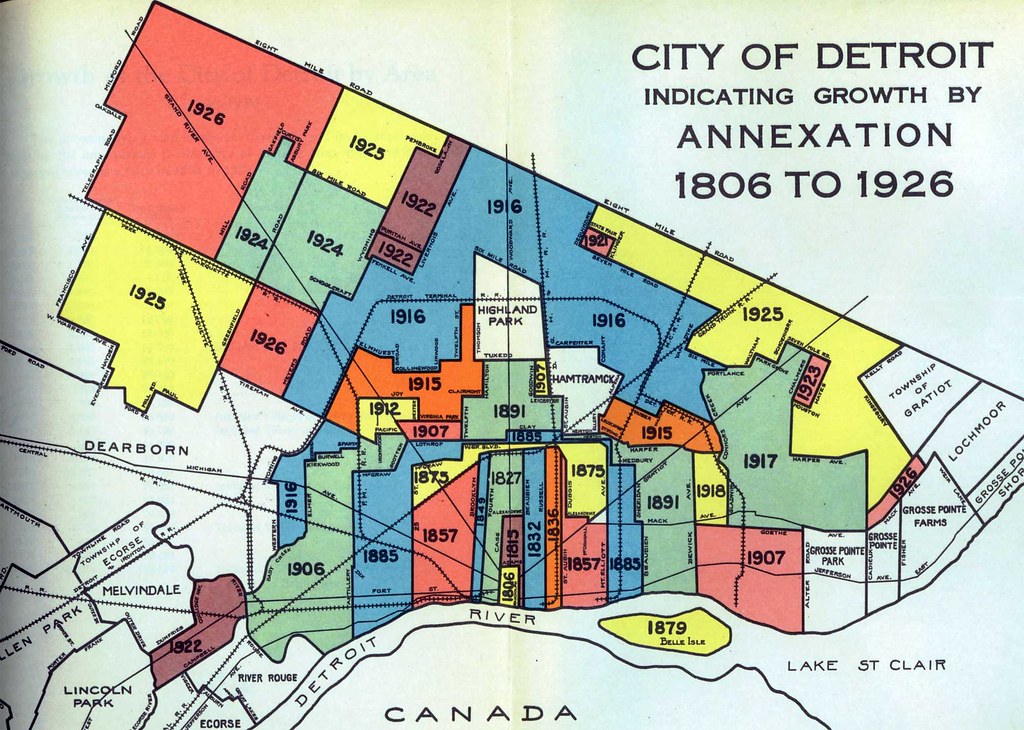
Interesting that the 1879-80 western boundary for the City limits was 24th St.
NO W. Grand Blvd then.
Wonder when the western border was annexed to Livernois?
-
April-06-10, 01:16 PM #18
DetroitYES Member
- Join Date
- Mar 2009
- Posts
- 2,160
Western boundary was 25th from 1857 to 1885, when it was extended to Livernois [[Artillery).
-
April-06-10, 01:19 PM #19
DetroitYES Member
- Join Date
- Mar 2010
- Posts
- 186
Many thanks MikeM. Originally Posted by MikeM
Any idea when the eastern boundary was extended beyond Van Dyke?
Was there an earlier eastern boundary?
How about some early Northern Boundaries?
There must have been something earlier than Eight Mile [[Baseline) Rd?
TIA
-
April-06-10, 01:30 PM #20
DetroitYES Member
- Join Date
- Mar 2009
- Posts
- 6,543
Detroit also annex what's left of Springwells TWP in 1913, Del-Rey in after 1910 and the piece of Lonyo to Wyoming Streets in 1917. Originally Posted by MikeM
Fordson Village and parts of Dearborn TWP. was annexed to Dearbornville in after 1920 and thus the City of Dearborn was born. It was meant to keep Detroit from annexing the Aviation Sub-Division.
Henry Ford threaten to have all of Dearborn annexed to Detroit if he doesn't have his Rouge Plant built near the Rouge River Industrial Complex. So the City of Dearborn let Ford built his plant.
-
April-06-10, 01:55 PM #21
DetroitYES Member
- Join Date
- Mar 2009
- Posts
- 6,543
The eastern boundry from Downtown Detroit in 1830s extended from Joseph Compau St. to the corner of E. Warren Ave. By 1850s up to Mt Eilliot St. to E. Warren Ave. By 1960s up to E. Grand Blvd. by 1880s up to Harper St. by 1920 Detroit annex what's lefy of Grosse Pointe TWP. The Citizens of Grosse Pointe rushed to incorporate into a village and later broke up into 5 suburbs of Grosse Pointe Park, Grosse Pointe, Grosse Pointe Farms, Grosse Pointe Woods and Grosse Pointe Shores. Detroit annexed parts of Gratiot TWP to for the development of Mohican Regent, Greensbriar, Regent Park and Van Stuben in 1928. What's left of the Township became Harper Woods. Originally Posted by wilderness
Detroit annexed what's left of Hamtramck TWP. [[ up to the northern boundries of E. 8 Mile Rd.) after 1910, but the people of the Village of Hamtramck [[ from Carpenter Rd. to Clay St. from Dequindre Rd. to few neighborhoods blocks east of Conant) rushed to vote for their area to become the City of Hamtramck.
The northern boundries of Hamtramck TWPe was a just plan farming community in square acre plots until Mr. Conant came along the proposed a sub-division for African Americans after Detroit annexed Hamtramck TWP.
-
April-06-10, 02:02 PM #22
DetroitYES Member
- Join Date
- Mar 2009
- Posts
- 2,160
-
April-06-10, 05:00 PM #23
DetroitYES Member
- Join Date
- Apr 2009
- Posts
- 4,513
Thanks MikeM for a fascinating map. But for us old eastsiders there's a pretty glaring error there. The 1885 eastern border is given on the map as "Beaubien," but with the line being east of Mt. Elliott that clearly is wrong. From the location and from what I know of the history of the area I'd guess that they meant Baldwin.
-
April-06-10, 06:40 PM #24
DetroitYES Member
- Join Date
- Mar 2009
- Posts
- 2,160
Yes, definitely Baldwin, not Beaubien.
-
April-19-10, 02:24 PM #25
DetroitYES Member
- Join Date
- Apr 2010
- Posts
- 50
This looks like it might be a Hearne Bros. map. The company [[letterpress and lithographic cartography) was located in the old Trappers Alley/Traugott Schmidt Building in Greektown. The company was on its last legs - about two employees were keeping the place running - when I first started working in the building for a design and display company in 1979. [[Mario's Mannequins was in the same building upstairs back then.) Hearne Bros. made city directories, large maps and pull-down charts that used to be used in school classrooms.
I have a section of a downtown Detroit street map I "block printed" from one of their discarded letterpress dies. The type style looks similar to the image posted at the start of this message. Couldn't find much on Google related to Hearn Bros. maybe others have ideas/info about the company.

 Reply With Quote
 Instagram
DetroitYES navigation
DetroitYES Management
© AtDetroit LLC 2000 - 2024 unless otherwise specified. Please notify us of uncited proprietary content.
Welcome to DetroitYES! Kindly Consider Turning Off Your Ad BlockingX
DetroitYES! is a free service that relies on revenue from ad display [regrettably] and donations. We notice that you are using an ad-blocking program that prevents us from earning revenue during your visit.
Ads are REMOVED for Members who donate to DetroitYES! [You must be logged in for ads to disappear]
Ads are REMOVED for Members who donate to DetroitYES! [You must be logged in for ads to disappear]
DONATE HERE »
And have Ads removed.
And have Ads removed.
Bookmarks