


This takes issue with the argument made in the michigan radio article.Originally Posted by jcole

http://corktownhistory.blogspot.com/...ards-plan.html
Results 26 to 35 of 35
-
October-23-14, 09:20 AM #26
 DetroitYES Member
- Join Date
- Oct 2011
- Posts
- 43

-
October-23-14, 01:44 PM #27
 DetroitYES Member
- Join Date
- Mar 2009
- Posts
- 9,432
I'm not sure what point you were trying to make here? Originally Posted by nain rouge

That all the streets at GCP should have just run together? Or that Detroit should have scrapped Woodward's entire plan?
Just look at NYC... Downtown NYC is very similar to the Woodward plan [[but much more chaotic) in that there are streets going off at so many angles. And it makes downtown NYC an interesting place to view NYC skyscrapers. By the time you get to Midtown NYC, the street grid has taken over... and has left a rather monotonous arrangement of streets... where taking a photo of the Empire State Building at a good angle is virtually impossible.
Ironically the most interesting and most photogenic [[and famous) parts of Midtown NYC are those that are bisected by crooked running Broadway Ave.... such as Times Square, Colombus Circle, Madison Square, Herald Square and Union Square.
By the same token it's Detroit's Woodward Plan streets that provide downtown Detroit with so many interesting vistas as well. Few ballparks can claim such a grand view of a downtown as you get from Comerica Park... thanks to Woodward's Plan, and GCP.
Had Grand Circus Park, even in just its' beautiful half completed state, not been built... the intersection where all those streets converged would have been like Campus Martius used to be back in the 1990s... just a large confusing clusterfuck junction of streets. Campus Martius cleaned all that up in a very nice way... they put a park in the middle. GCP conveniently already has that.
Before the destruction of the Statler and Tuller blocks back in the mid 20th century... when an out-of-town visitor was walking down Woodward to Adams, he came upon an unexpected grand vista of noble buildings... and if he turned his head in 360 degrees at night... he was able to see all the lit up marquees of all of the theatre's in the district... a "Grand" display.
It's the layout of what we have today at Grand Circus Park... that we should be thankful for.... now if only more of the buildings had survived...
-
October-23-14, 01:58 PM #28
DetroitYES Member
- Join Date
- Apr 2009
- Posts
- 40
EastsideAl's answer is right, but I just wanted to add another detail. The land immediately on both sides of Woodward was subdivided first, but it was not part of any of the ribbon farms. In 1806, Congress granted the Governor and Judges authority to lay out the new [[post-fire) town, plus survey 10,000 acres of public land and sell it to build a courthouse, jail, and fund other necessities. The first part of this 10,000 acres of land to be surveyed was that just north of Adams Avenue *in between* the Cass and Brush farms, up to around Piquette Street. In 1808, this strip of land was divided into what were known as the Park Lots. There are 86 in all, and a copy of the plat can be seen here if your Java is up to date: http://www.dleg.state.mi.us/platmaps..._SUBINDEX=8018
What I'm getting at is that a bunch of dudes just bought these lots [[or the lots themselves were given as payment) and the new owners proceeded to put streets on them wherever they wanted. Some put side streets on the outer edges of their lots, some put streets going through the middle. None of them really cared if their streets mirrored the ones on the other side of Woodward. That's how quickly it took for the Woodward Plan to be ignored.
In 1816, the rest of the 10,000 acres [[the vast majority of it) was surveyed and sold off as quarter-mile square farms, and that chunk of land now includes New Center, Hamtramck, and Highland Park.
-
October-23-14, 02:29 PM #29
DetroitYES Member
- Join Date
- Apr 2012
- Posts
- 1,071
Originally Posted by Gistok
I agree that Grand Circus Park has an inherit beauty. It's photogenic, sure. But is it even close to being efficient at moving modern forms of traffic, whether public or private? No, absolutely not. It's a relic of the horse and carriage era.
Now if it was a full circle, it could've been infinitely more useful.
-
October-23-14, 02:37 PM #30
DetroitYES Member
- Join Date
- Apr 2009
- Posts
- 1,684
I know you're ranting mostly about driving east and west, but since you also bring up walkability, I have to defend the DMC. When I worked in the area, I would often take my lunchtime walks through the DMC campus. Specifically, the pedestrian mall that runs north and south from Canfield to Mack was my favorite. It was a bit of a patchwork affair that required a jog or two to get all the through, but I felt that added to its charm, and also inspired taking a slightly different path every day. This time of the year was the best as many trees would be turning spectacular colors. Originally Posted by SpartanDawg
-
October-23-14, 02:45 PM #31
DetroitYES Member
- Join Date
- Apr 2009
- Posts
- 1,684
I don't understand why you're dissing Grand Circus Park. Woodward, the largest street in the area goes straight through it. How would a circle have made that any easier? The bigger problem in that area, in my opinion, is the detours necessary to navigate around the stadia. Originally Posted by nain rouge
-
October-24-14, 01:18 AM #32
DetroitYES Member
- Join Date
- Apr 2009
- Posts
- 4,513
Great summation of the history of the subdivision of land in the center city. Here is piece of a map showing what was then Detroit [[the Woodward plan section downtown), the Park Lots [[pink strip running north from downtown), the Ten Thousand Acre Tract [[big rectangle in the middle), and the surrounding ribbon farms Originally Posted by PSewick
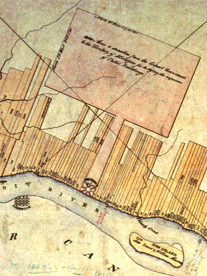
Here is a good map showing the survey of various parts of what would become the city of Detroit. This gives a good idea of why our streets are laid out the way they are in different parts of the city.
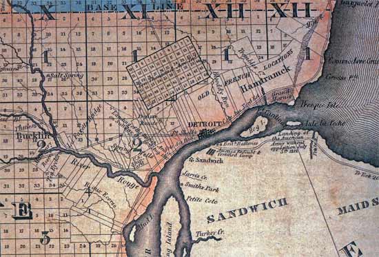
These are both taken from MikeM's excellent posts on this interesting thread about the 10,000 Acre Tract.
http://www.atdetroit.net/forum/messa...tml?1173667967
-
October-24-14, 01:35 AM #33
DetroitYES Member
- Join Date
- Jul 2011
- Posts
- 1,325
Geez, what a complicated mess of planning. Those damn farmers sure had a lot of influence.
-
October-24-14, 03:25 PM #34
DetroitYES Member
- Join Date
- Apr 2009
- Posts
- 4,513
Again though, not really "planned" in the way we think of it now. Most of Detroit just grew organically in small subdivisions by landowners, as population growth demanded. First along the farm lines laid out oriented to the river by the French [[and the early American 10,000 acre tract on the same orientation), then along the directionally-oriented lines laid out by the Northwest Ordinance surveys.
-
October-24-14, 04:37 PM #35
DetroitYES Member
- Join Date
- Jan 2010
- Posts
- 4,867
Note also the northeastern alignment on the lake which gives us Morross, Kelly, and Whittier which differ slightly from the older city alignment. Originally Posted by EastsideAl

 Reply With Quote
 Posting Permissions
Instagram
DetroitYES navigation
DetroitYES Management
© AtDetroit LLC 2000 - 2024 unless otherwise specified. Please notify us of uncited proprietary content.
Welcome to DetroitYES! Kindly Consider Turning Off Your Ad BlockingX
DetroitYES! is a free service that relies on revenue from ad display [regrettably] and donations. We notice that you are using an ad-blocking program that prevents us from earning revenue during your visit.
Ads are REMOVED for Members who donate to DetroitYES! [You must be logged in for ads to disappear]
Ads are REMOVED for Members who donate to DetroitYES! [You must be logged in for ads to disappear]
DONATE HERE »
And have Ads removed.
And have Ads removed.
Bookmarks